METAR & TAF Y49
Current METAR
Observed 21:35Z
KY49 272135Z AUTO 00000KT 10SM CLR 30/20 A2980 RMK AO2 T02990198
- Wind
- 000° @ 0 kt
- Visibility
- 10 SM
- Temp / Dew
- 30°C / 20°C
- Altimeter
- 29.80 inHg
- Clouds
- CLR
- Density alt
- 3,621 ft
- Ceiling
- Unlimited
- Rules
- VFR
Airport info & contacts
Manager on record, flight service, ARTCC, attendance schedule and pattern altitude — published by the FAA and refreshed every 28 days.
Location
- From city
- 4 NM NW
- VFR sectional
- TWIN CITIES
- ARTCC
- ZMP · MINNEAPOLIS
- NOTAM facility
- PNM (NOTAM-D)
Airport manager
- Name
- HOPE FAIRCHILD
- Phone
- (218) 547-5501
- Address
- 205 MINNESOTA AVE WEST, WALKER MN 56484
Flight service · Hours
- FSS PNM
- PRINCETON1-800-WX-BRIEF
- Attendance
- Unattended
Frequencies
Tap any row to copy the frequency to your clipboard.
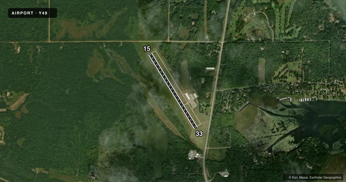
Runways & pattern
Full pagePattern entry · RWY 15
LEFT TRAFFICRunway end performance
| End | TORA | TODA | ASDA | LDA | VGSI | Approach lights | Obstruction |
|---|---|---|---|---|---|---|---|
| 15 | — | — | — | — | PAPI 4-box left(3°) | — | trees, slope 20 |
| 33 | — | — | — | — | PAPI 4-box left(3°) | — | 101', trees, 1894' from thr, 336' R of cntrln, slope 16 |
Declared distances in feet. TORA = takeoff run available, TODA = takeoff distance, ASDA = accelerate-stop, LDA = landing distance.
Airport sketch
Runways drawn to scale from FAA survey coordinates, rendered over satellite imagery. Not for navigation.
Approaches & charts
Services on the field
Fuel grades, oxygen, maintenance, ramp storage and lighting — as declared to the FAA by the airport operator.
Fuel & services
- Fuel
- 100LL
- Oxygen (bottled)
- Not available
- Oxygen (bulk)
- Not available
- Airframe repair
- Not available
- Power plant repair
- Not available
- Other services
- INSTR,RNTL,SURV
Ramp & ground
- Transient storage
- Tie-down
- Hangar
- Landing fee
- No fee published
- Customs
- Not available
- Lighting schedule
- SEE RMK
- Beacon schedule
- SS-SR
- Beacon
- White / Green (civil land)(WG)
- Wind indicator
- Lighted
- Segmented circle
- No
Fuel & FBOs
Cheapest 100LL and Jet A on the field and nearby. Always confirm with the FBO before taxi.
Airport notes
Surface conditions, obstructions, local procedures, lighting outages and other notes published with each FAA cycle.
General notes
- FOR CD CTC MINNEAPOLIS ARTCC AT 651-463-5588.
Lighting notes
- MIRL RY 15/33 PRESET TO LOW SS-SR; INCR INTST & ACTVT REIL RY 15 & 33; PAPI RY 15 & 33 - CTAF.
Fuel notes
- 100LLFUEL AVBL 24 HOURS BY CREDIT CARD.
VFR map & nearby airports
VFR sectional. Tap any ICAO chip to open that airport.
Key facts · Y49
Answer card- ICAO
- Y49
- Name
- WALKER MUNI
- Location
- WALKER, MINNESOTA
- Elevation
- 1,348.4 ft MSL
- Traffic pattern altitude
- 2,348.4 ft MSL (1,000 AGL)
- Control tower
- Non-towered (use CTAF)
- Total runways
- 1
- Longest runway
- 15/33 · 3,220 ft
- Published ILS approaches
- 0
- Published frequencies
- 1
- Magnetic variation
- 1°
- Current flight rules
- VFR
- Current wind
- 000° at 0 kt
- Favored runway now
- –
Walker Muni is in Walker, Minnesota. The field elevation is 1,348.4 ft MSL. It has one runway. Runway 15/33 is 3,220 ft of asphalt, which is the longest runway on the field. There is no control tower. CTAF is 122.9.
No ILS approaches are published here. Pattern altitude is not published. Use standard 1,000 ft AGL unless the current Chart Supplement says otherwise. That puts the light-piston pattern at about 2,348 ft MSL based on the field elevation. Verify the published pattern before you go. The published remarks also note 24-hour 100LL fuel by credit card. Runway lighting is set to low from sunset to sunrise. Pilots can raise the intensity and turn on runway end identifier lights on runways 15 and 33. The PAPI on both runway ends is activated by CTAF.
For clearance delivery, contact Minneapolis ARTCC at 651-463-5588. There are no on-field FBOs listed in the facts. Verify services with the airport operator before arrival. This is a non-towered field in northern Minnesota. Plan for a self-announce pattern, local traffic and winter weather that can change runway conditions fast. Check the current Chart Supplement for any published noise or curfew restrictions before flying into the field.