METAR & TAF KXVG
Current METAR
Observed 21:33Z
KXVG 272133Z AUTO 33004KT 10SM CLR 30/20 A2980 RMK AO2
- Wind
- 330° @ 4 kt
- Visibility
- 10 SM
- Temp / Dew
- 30°C / 20°C
- Altimeter
- 29.80 inHg
- Clouds
- CLR
- Density alt
- 3,606 ft
- Ceiling
- Unlimited
- Rules
- VFR
Airport info & contacts
Manager on record, flight service, ARTCC, attendance schedule and pattern altitude — published by the FAA and refreshed every 28 days.
Location
- From city
- 1 NM NE
- VFR sectional
- TWIN CITIES
- ARTCC
- ZMP · MINNEAPOLIS
- NOTAM facility
- XVG (NOTAM-D)
Airport manager
- Name
- CHRISTINA HERHEIM
- Phone
- 218-363-2022
- Address
- PO BOX 217, LONGVILLE MN 56655-0217
Flight service · Hours
- FSS PNM
- PRINCETON1-800-WX-BRIEF
- Attendance
- Unattended
Frequencies
Tap any row to copy the frequency to your clipboard.
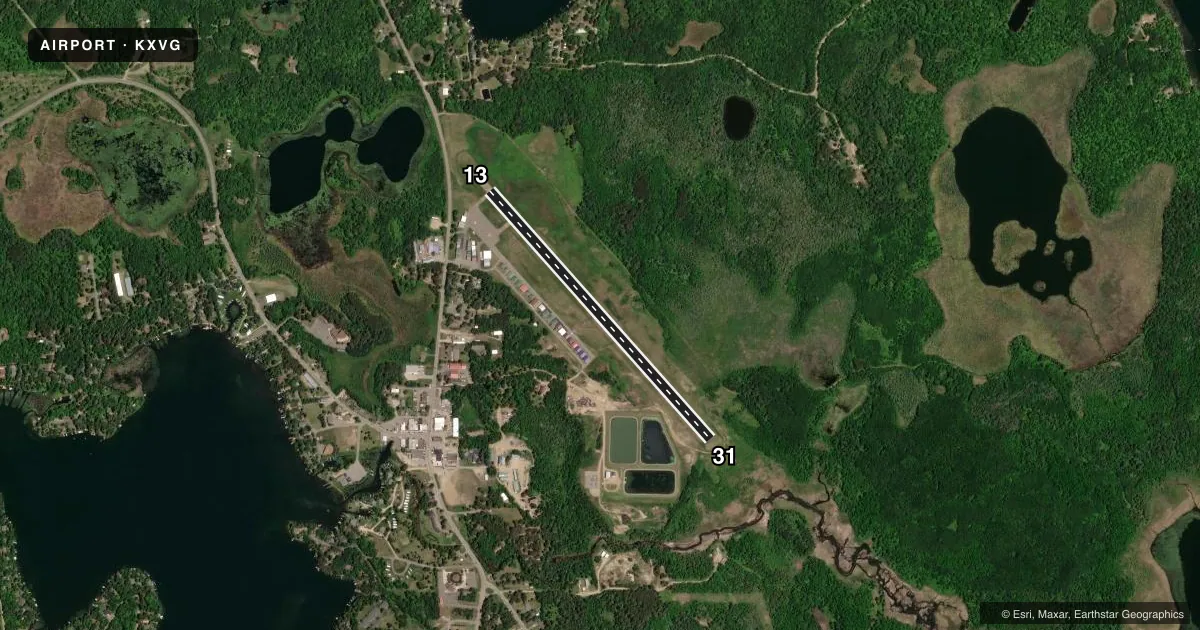
Runways & pattern
Full pagePattern entry · RWY 31
LEFT TRAFFICRunway end performance
| End | TORA | TODA | ASDA | LDA | VGSI | Approach lights | Obstruction |
|---|---|---|---|---|---|---|---|
| 13 | 3,549' | 3,549' | 3,549' | 3,109' | PAPI 4-box left(4°) | — | 20', road, 334' from thr, 250' R of cntrln, slope 6 |
| 31 | 3,549' | 3,549' | 3,549' | 3,549' | PAPI 4-box left(3°) | — | — |
Declared distances in feet. TORA = takeoff run available, TODA = takeoff distance, ASDA = accelerate-stop, LDA = landing distance.
Airport sketch
Runways drawn to scale from FAA survey coordinates, rendered over satellite imagery. Not for navigation.
Approaches & charts
Services on the field
Fuel grades, oxygen, maintenance, ramp storage and lighting — as declared to the FAA by the airport operator.
Fuel & services
- Fuel
- 100LL
- Other services
- SALES
Ramp & ground
- Transient storage
- Tie-down
- Landing fee
- No fee published
- Customs
- Not available
- Lighting schedule
- SEE RMK
- Beacon schedule
- SS-SR
- Beacon
- White / Green (civil land)(WG)
- Wind indicator
- Lighted
- Segmented circle
- No
Fuel & FBOs
Cheapest 100LL and Jet A on the field and nearby. Always confirm with the FBO before taxi.
Airport notes
Surface conditions, obstructions, local procedures, lighting outages and other notes published with each FAA cycle.
General notes
- DEER & BIRDS ON & INVOF ARPT.
- GCO AVBL ON FREQ 121.725 THRU MINNEAPOLIS ARTCC & PRINCETON FSS.
- FOR CD IF UNA VIA GCO CTC MINNEAPOLIS ARTCC AT 651-463-5588.
Lighting notes
- ACTVT PAPI RWY 13 & 31; MIRL RWY 13/31 - CTAF.
Fuel notes
- 100LLFUEL AVBL H24 SELF SVC VIA CREDIT CARD.
VFR map & nearby airports
VFR sectional. Tap any ICAO chip to open that airport.
Key facts · KXVG
Answer card- ICAO
- KXVG
- Name
- LONGVILLE MUNI
- Location
- LONGVILLE, MINNESOTA
- Elevation
- 1,336.8 ft MSL
- Traffic pattern altitude
- 2,336.8 ft MSL (1,000 AGL)
- Control tower
- Non-towered (use CTAF)
- Total runways
- 1
- Longest runway
- 13/31 · 3,549 ft
- Published ILS approaches
- 0
- Published frequencies
- 1
- Magnetic variation
- 3°
- Current flight rules
- VFR
- Current wind
- 330° at 4 kt
- Favored runway now
- RWY 31
Longville Muni sits in Longville, Minnesota. The field elevation is 1,336.8 ft MSL. It has one runway, 13/31, at 3,549 ft on asphalt. The airport is non-towered, so expect self-announce traffic on CTAF 122.9.
No ILS approaches are published here. Pattern altitude is not published in the facts, so use the standard 1,000 ft AGL for light piston traffic unless the current FAA Chart Supplement says otherwise. The on-field FBO is Longville Municipal Airport. It carries 100LL. Fuel is available 24 hours a day as self-serve with credit card. PAPI is available for runways 13 and 31. Medium intensity runway lights are activated on CTAF for those runways.
A first-time pilot should watch for deer and birds in the airport area. That matters here. If you need clearance delivery and cannot reach it through the ground communications outlet, the published remark points you to Minneapolis ARTCC. The ground communications outlet is available on 121.725 through Minneapolis ARTCC and Princeton Flight Service Station. Check the current FAA Chart Supplement before flight for any updated remarks or local procedures.