METAR & TAF 7Y3
7Y3 does not publish a METAR.
Showing the nearest reporting station: KPWC (PINE RIVER RGNL) · 8.0 NM away. Conditions at 7Y3 may differ.
METAR · KPWC
Observed 04:35Z
KPWC 250435Z AUTO 16003KT 10SM 22/20 A2985 RMK AO2 LTG DSNT N AND NE T02170201 $
- Wind
- 160° @ 3 kt
- Visibility
- 10 SM
- Temp / Dew
- 22°C / 20°C
- Altimeter
- 29.85 inHg
- Clouds
- Clear
- Density alt
- 2,605 ft
- Ceiling
- Unlimited
- Rules
- VFR
Airport info & contacts
Manager on record, flight service, ARTCC, attendance schedule and pattern altitude — published by the FAA and refreshed every 28 days.
Location
- From city
- 1 NM NE
- VFR sectional
- TWIN CITIES
- ARTCC
- ZMP · MINNEAPOLIS
- NOTAM facility
- PNM (NOTAM-D)
Airport manager
- Name
- ANN SWANSON
- Phone
- 218-839-8450
- Address
- PO BOX 44, BACKUS MN 56435-2605
Flight service · Hours
- FSS PNM
- PRINCETON1-800-WX-BRIEF
- Attendance
- Unattended
Frequencies
Tap any row to copy the frequency to your clipboard.
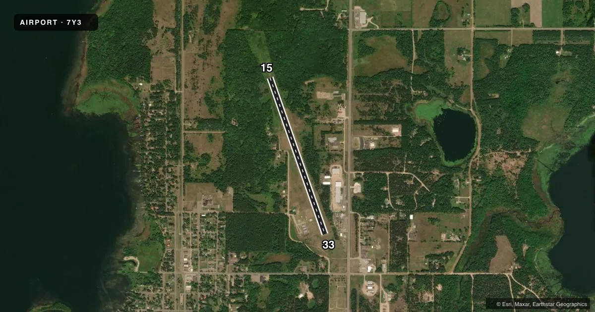
Runways & pattern
Full pagePattern entry · RWY 15
LEFT TRAFFICRunway end performance
| End | TORA | TODA | ASDA | LDA | VGSI | Approach lights | Obstruction |
|---|---|---|---|---|---|---|---|
| 15 | — | — | — | — | — | — | 6', trees, 88' from thr, 91' R of cntrln, slope 14 |
| 33 | — | — | — | — | PAPI 2-box left(4°) | — | 47', trees, 601' from thr, 182' R of cntrln, slope 12 |
Declared distances in feet. TORA = takeoff run available, TODA = takeoff distance, ASDA = accelerate-stop, LDA = landing distance.
Airport sketch
Runways drawn to scale from FAA survey coordinates, rendered over satellite imagery. Not for navigation.
Approaches & charts
Services on the field
Fuel grades, oxygen, maintenance, ramp storage and lighting — as declared to the FAA by the airport operator.
Fuel & services
- Fuel
- 100LLMOGAS
Ramp & ground
- Transient storage
- Tie-down
- Landing fee
- No fee published
- Lighting schedule
- SEE RMK
- Beacon schedule
- SS-SR
- Beacon
- White / Green (civil land)(WG)
- Wind indicator
- Lighted
- Segmented circle
- No
Fuel & FBOs
Cheapest 100LL and Jet A on the field and nearby. Always confirm with the FBO before taxi.
Airport notes
Surface conditions, obstructions, local procedures, lighting outages and other notes published with each FAA cycle.
General notes
- ULTRALIGHT ACTIVITY ON & INVOF ARPT.
- NMRS PRIM SFC PENETRATIONS.
- FOR CD CTC MINNEAPOLIS ARTCC AT 651-463-5588.
Lighting notes
- ACTVT NSTD LIRL RWY 15/33 - CTAF. PAPI RWY 33 OTS INDEFLY.
Fuel notes
- 100LLFUEL AVBL H24 VIA CREDIT CARD.
Runway surface & condition
- 15/33NSTD LIRL DUE TO SPACING.
Approach & departure obstructions
- 15YELLOW CONES.
- 33YELLOW CONES.
Other notes
- 15/33SAND SHOWING THROUGH TURF.
VFR map & nearby airports
VFR sectional. Tap any ICAO chip to open that airport.
Key facts · 7Y3
Answer card- ICAO
- 7Y3
- Name
- BACKUS MUNI
- Location
- BACKUS, MINNESOTA
- Elevation
- 1,353 ft MSL
- Traffic pattern altitude
- 2,353 ft MSL (1,000 AGL)
- Control tower
- Non-towered (use CTAF)
- Total runways
- 1
- Longest runway
- 15/33 · 3,585 ft
- Published ILS approaches
- 0
- Published frequencies
- 1
- Magnetic variation
- 4°
- Current flight rules
- VFR
- Current wind
- 160° at 3 kt
- Favored runway now
- RWY 15
Backus Muni sits in Backus, Minnesota. The field elevation is 1,353 ft MSL. It has one runway, 15/33, which is 3,585 ft long and turf. The airport is non-towered. CTAF is 122.9. No ILS approaches are published here.
Pattern altitude is not published. Use the standard 1,000 ft AGL pattern unless local guidance says otherwise. The published remarks matter here. Ultralight activity occurs on and near the airport. Runway 15/33 has nonstandard low-intensity lighting that is activated by CTAF. The PAPI on runway 33 is out of service indefinitely. Yellow cones mark both runway ends. Sand is showing through the turf surface, so expect a soft field feel and check the runway condition before you commit.
100LL is available 24 hours by credit card. No on-field FBOs are listed, so verify services with the airport operator before you go. Clearance delivery is handled through Minneapolis ARTCC at 651-463-5588. Numerous primary surface penetrations are noted in the Chart Supplement, so keep a sharp eye out on approach and departure. This is a good airport for a careful brief. Plan for turf performance. Watch for ultralights. Confirm lighting and surface condition before a night or low-visibility arrival.