METAR & TAF KSAZ
Current METAR
Observed 16:55Z
KSAZ 271655Z AUTO 33011KT 10SM CLR 32/21 A2976 RMK AO2 T03170214 $
- Wind
- 330° @ 11 kt
- Visibility
- 10 SM
- Temp / Dew
- 32°C / 21°C
- Altimeter
- 29.76 inHg
- Clouds
- CLR
- Density alt
- 3,835 ft
- Ceiling
- Unlimited
- Rules
- VFR
Airport info & contacts
Manager on record, flight service, ARTCC, attendance schedule and pattern altitude — published by the FAA and refreshed every 28 days.
Location
- From city
- 2 NM NW
- VFR sectional
- TWIN CITIES
- ARTCC
- ZMP · MINNEAPOLIS
- NOTAM facility
- SAZ (NOTAM-D)
Airport manager
- Name
- JEREL NELSEN
- Phone
- 218-894-2550
- Address
- 122 6TH ST NE, STAPLES MN 56479-2900
Flight service · Hours
- FSS PNM
- PRINCETON1-800-WX-BRIEF
- Attendance
- Unattended
Frequencies
Tap any row to copy the frequency to your clipboard.
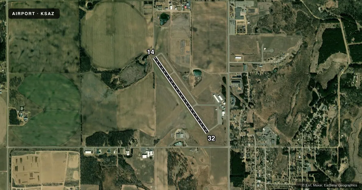
Runways & pattern
Full pagePattern entry · RWY 32
LEFT TRAFFICRunway end performance
| End | TORA | TODA | ASDA | LDA | VGSI | Approach lights | Obstruction |
|---|---|---|---|---|---|---|---|
| 14 | — | — | — | — | PAPI 4-box left(3°) | — | 24', tree, 285' from thr, 261' R of cntrln, slope 3 |
| 32 | — | — | — | — | PAPI 4-box left(3°) | — | 53', tree, 1137' from thr, 291' R of cntrln, slope 17 |
Declared distances in feet. TORA = takeoff run available, TODA = takeoff distance, ASDA = accelerate-stop, LDA = landing distance.
Airport sketch
Runways drawn to scale from FAA survey coordinates, rendered over satellite imagery. Not for navigation.
Approaches & charts
Services on the field
Fuel grades, oxygen, maintenance, ramp storage and lighting — as declared to the FAA by the airport operator.
Fuel & services
- Fuel
- 100LL
- Oxygen (bottled)
- Not available
- Oxygen (bulk)
- Not available
- Airframe repair
- Not available
- Power plant repair
- Not available
- Other services
- AGRI,INSTR,RNTL,SALES
Ramp & ground
- Transient storage
- Tie-down
- Landing fee
- No fee published
- Customs
- Not available
- Lighting schedule
- SEE RMK
- Beacon schedule
- SS-SR
- Beacon
- White / Green (civil land)(WG)
- Wind indicator
- Lighted
- Segmented circle
- No
Fuel & FBOs
Cheapest 100LL and Jet A on the field and nearby. Always confirm with the FBO before taxi.
Airport notes
Surface conditions, obstructions, local procedures, lighting outages and other notes published with each FAA cycle.
General notes
- GCO AVBL ON FREQ 121.725 THRU MINNEAPOLIS ARTCC & FLT SVCS.
- ULTRALIGHT TFC ON & INVOF ARPT.
- FOR CD IF UNA VIA GCO CTC MINNEAPOLIS ARTCC AT 651-463-5588.
Lighting notes
- ACTVT REIL RWY 14 & 32; PAPI RWY 14 & 32; MIRL RWY 14/32 - CTAF.
Fuel notes
- 100LLFUEL AVBL H24 SELF SVC VIA CREDIT CARD.
Approach & departure obstructions
- 147 FT BRUSH, 45 FT DIST, 189 FT R.
VFR map & nearby airports
VFR sectional. Tap any ICAO chip to open that airport.
Key facts · KSAZ
Answer card- ICAO
- KSAZ
- Name
- STAPLES MUNI
- Location
- STAPLES, MINNESOTA
- Elevation
- 1,287.6 ft MSL
- Traffic pattern altitude
- 2,287.6 ft MSL (1,000 AGL)
- Control tower
- Non-towered (use CTAF)
- Total runways
- 1
- Longest runway
- 14/32 · 3,305 ft
- Published ILS approaches
- 0
- Published frequencies
- 1
- Magnetic variation
- 1°
- Current flight rules
- VFR
- Current wind
- 330° at 11 kt
- Favored runway now
- RWY 32
Staples Muni is in Staples, Minnesota. The field elevation is 1,287.6 ft MSL. It has one runway, 14/32, which is 3,305 ft long and paved asphalt. There is no control tower. CTAF is 122.9.
No ILS approaches are published here. The pattern altitude is not published, so use the standard 1,000 ft AGL for light piston operations unless the current Chart Supplement says otherwise. Runway end identifier lights, PAPI and medium intensity runway lights are published for runway 14/32. Ultralight traffic is reported on and in the vicinity of the airport. Keep your scan active in the pattern.
The on-field FBO is Staples Municipal Airport. It carries AVGAS 100LL. Fuel is available 24 hours a day through self-serve credit card. There is also a ground communications outlet on 121.725 through Minneapolis ARTCC and flight services. If clearance delivery is not available through that outlet, contact Minneapolis Air Route Traffic Control Center directly. A 7-foot brush obstruction is published near runway 14, 189 ft right of centerline and 45 ft from the threshold. Check that side of the runway carefully on departure and landing.