METAR & TAF 9Y2
9Y2 does not publish a METAR.
Showing the nearest reporting station: KBRD (BRAINERD LAKES RGNL) · 10.0 NM away. Conditions at 9Y2 may differ.
METAR · KBRD
Observed 21:53Z
KBRD 272153Z AUTO 01008G17KT 10SM FEW046 FEW055 31/21 A2979 RMK AO2 SLP080 T03060206
- Wind
- 010° @ 8G17 kt
- Visibility
- 10 SM
- Temp / Dew
- 31°C / 21°C
- Altimeter
- 29.79 inHg
- Clouds
- FEW
- Density alt
- 3,614 ft
- Ceiling
- Unlimited
- Rules
- VFR
Airport info & contacts
Manager on record, flight service, ARTCC, attendance schedule and pattern altitude — published by the FAA and refreshed every 28 days.
Location
- From city
- 8 NM NW
- VFR sectional
- TWIN CITIES
- ARTCC
- ZMP · MINNEAPOLIS
- NOTAM facility
- PNM (NOTAM-D)
Airport manager
- Name
- LAURA CHRISTENSEN
- Phone
- 218-828-9279
- Address
- 10790 GULL POINT RD, 10790 SQUAW POINT ROAD, EAST GULL LAKE MN 56401-3088
Flight service · Hours
- FSS PNM
- PRINCETON1-800-WX-BRIEF
- Attendance
- Unattended
Frequencies
Tap any row to copy the frequency to your clipboard.
Runways & pattern
Full pagePattern entry · RWY 31
LEFT TRAFFICRunway end performance
| End | TORA | TODA | ASDA | LDA | VGSI | Approach lights | Obstruction |
|---|---|---|---|---|---|---|---|
| 13 | — | — | — | — | — | — | 32', tree, 434' from thr, 166' R of cntrln, slope 13 |
| 31 | — | — | — | — | — | — | 13', trees, 65' from thr, 104' R of cntrln, slope 5 |
Declared distances in feet. TORA = takeoff run available, TODA = takeoff distance, ASDA = accelerate-stop, LDA = landing distance.
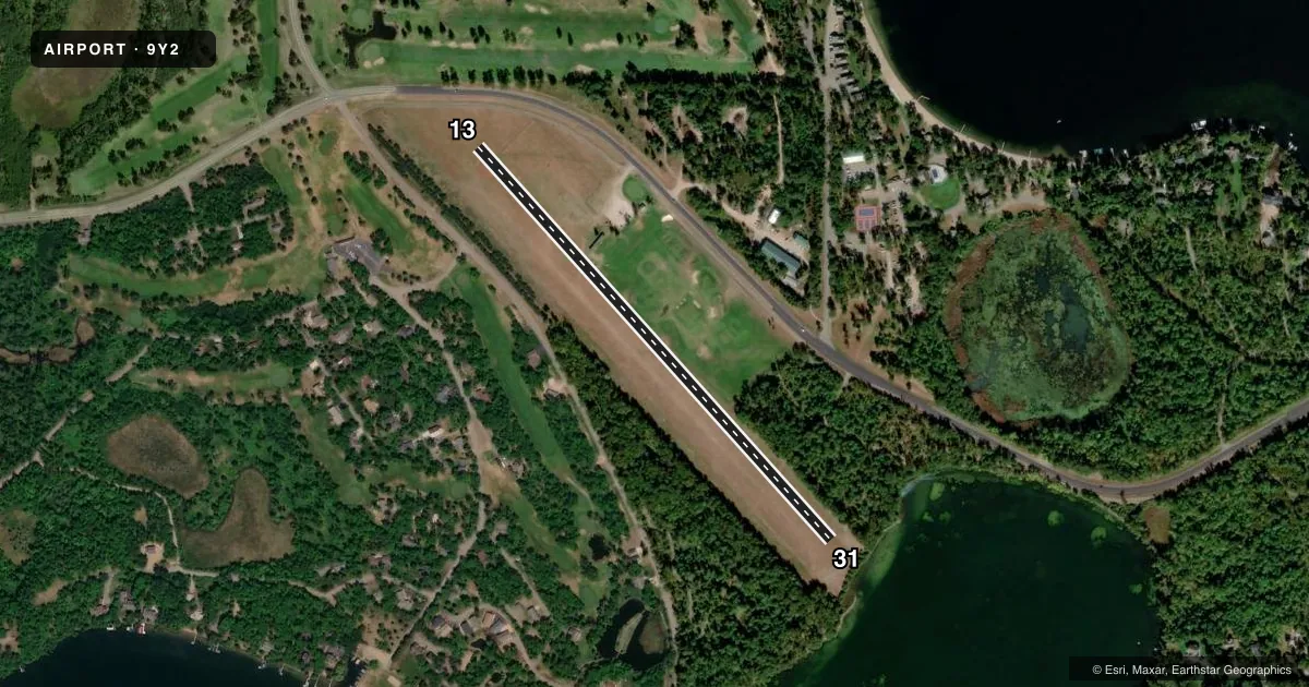
Airport sketch
Runways drawn to scale from FAA survey coordinates, rendered over satellite imagery. Not for navigation.
Approaches & charts
Services on the field
Fuel grades, oxygen, maintenance, ramp storage and lighting — as declared to the FAA by the airport operator.
Fuel & services
- Fuel
- Not available
- Other services
- INSTR
Ramp & ground
- Transient storage
- Tie-down
- Landing fee
- No fee published
- Wind indicator
- Yes
- Segmented circle
- No
Fuel & FBOs
Cheapest 100LL and Jet A on the field and nearby. Always confirm with the FBO before taxi.
Airport notes
Surface conditions, obstructions, local procedures, lighting outages and other notes published with each FAA cycle.
General notes
- ARPT NOT PLOWED WINTER MONTHS.
- WATCH FOR VEHICLES & PEDESTRIANS CROSSING RY.
- FOR CD CTC MINNEAPOLIS ARTCC AT 651-463-5588.
Approach & departure obstructions
- 13YELLOW CONES.
- 31YELLOW CONES.
VFR map & nearby airports
VFR sectional. Tap any ICAO chip to open that airport.
Key facts · 9Y2
Answer card- ICAO
- 9Y2
- Name
- EAST GULL LAKE
- Location
- EAST GULL LAKE, MINNESOTA
- Elevation
- 1,236 ft MSL
- Traffic pattern altitude
- 2,236 ft MSL (1,000 AGL)
- Control tower
- Non-towered (use CTAF)
- Total runways
- 1
- Longest runway
- 13/31 · 2,618 ft
- Published ILS approaches
- 0
- Published frequencies
- 1
- Magnetic variation
- 4°
- Current flight rules
- VFR
- Current wind
- 010° at 8 kt
- Favored runway now
- RWY 31
East Gull Lake Airport (9Y2) is in East Gull Lake, Minnesota. The field elevation is 1,236 ft MSL. It has one runway, 13/31, which is 2,618 ft long and surfaced with turf. The airport is not towered. CTAF is 122.9. No ILS approaches are published here.
Pattern altitude is not published. Use 1,000 ft AGL as the standard light-piston pattern reference unless the current Chart Supplement says otherwise. That puts the pattern at about 2,236 ft MSL based on the field elevation. Runway 13 and Runway 31 are marked with yellow cones. Watch for vehicles and pedestrians crossing the runway. The airport is not plowed during winter months. Surface condition matters a lot before you launch or divert in.
There are no on-field FBOs listed. Plan on verifying services with the airport operator or the field on CTAF before arrival. For clearance delivery, contact Minneapolis ARTCC at 651-463-5588. This is a turf strip with no published ILS. A first-time pilot should plan for visual conditions, soft-field technique and a close look at seasonal runway condition before committing.