METAR & TAF KLXL
Current METAR
Observed 11:15Z
KLXL 271115Z AUTO 30004KT 10SM CLR 23/21 A2973 RMK AO2
- Wind
- 300° @ 4 kt
- Visibility
- 10 SM
- Temp / Dew
- 23°C / 21°C
- Altimeter
- 29.73 inHg
- Clouds
- CLR
- Density alt
- 2,588 ft
- Ceiling
- Unlimited
- Rules
- VFR
Airport info & contacts
Manager on record, flight service, ARTCC, attendance schedule and pattern altitude — published by the FAA and refreshed every 28 days.
Location
- From city
- 2 NM S
- VFR sectional
- TWIN CITIES
- ARTCC
- ZMP · MINNEAPOLIS
- NOTAM facility
- LXL (NOTAM-D)
Airport manager
- Name
- TOM OLSON
- Phone
- 320-616-5525
- Address
- 13129 AIRPORT RD, LITTLE FALLS MN 56345-5777
Flight service · Hours
- FSS PNM
- PRINCETON1-800-WX-BRIEF
- Attendance
- MON-FRI · 0800-1700
Frequencies
Tap any row to copy the frequency to your clipboard.
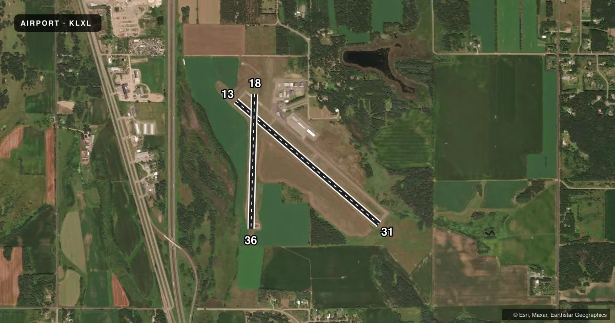
Runways & pattern
Full pagePattern entry · RWY 31
LEFT TRAFFIC| Runway | Heading (°M) | Length | Surface | Traffic |
|---|---|---|---|---|
| 13/31Favored | 128° / 308° | 4,010 ft | ASPH | Standard L |
| 18/36 | 178° / 358° | 2,858 ft | ASPH | Standard L |
Runway end performance
| End | TORA | TODA | ASDA | LDA | VGSI | Approach lights | Obstruction |
|---|---|---|---|---|---|---|---|
| 13 | — | — | — | — | PAPI 4-box right(3°) | — | — |
| 31 | — | — | — | — | PAPI 4-box left(3°) | — | — |
| 18 | 2,856' | 2,856' | 2,856' | 2,856' | — | — | — |
| 36 | 2,856' | 2,856' | 2,856' | 2,856' | — | — | — |
Declared distances in feet. TORA = takeoff run available, TODA = takeoff distance, ASDA = accelerate-stop, LDA = landing distance.
Airport sketch
Runways drawn to scale from FAA survey coordinates, rendered over satellite imagery. Not for navigation.
Approaches & charts
Services on the field
Fuel grades, oxygen, maintenance, ramp storage and lighting — as declared to the FAA by the airport operator.
Fuel & services
- Fuel
- 100LLUL91
- Oxygen (bottled)
- Not available
- Oxygen (bulk)
- Not available
- Airframe repair
- Minor
- Power plant repair
- Not available
- Other services
- INSTR,RNTL,SALES,SURV
Ramp & ground
- Transient storage
- Tie-down
- Hangar
- Landing fee
- No fee published
- Customs
- Not available
- Lighting schedule
- SEE RMK
- Beacon schedule
- SS-SR
- Beacon
- White / Green (civil land)(WG)
- Wind indicator
- Lighted
- Segmented circle
- No
Fuel & FBOs
Cheapest 100LL and Jet A on the field and nearby. Always confirm with the FBO before taxi.
Airport notes
Surface conditions, obstructions, local procedures, lighting outages and other notes published with each FAA cycle.
General notes
- GCO AVBL ON FREQ 121.725 THRU MINNEAPOLIS ARTCC & FLT SVCS.
- RWY 36 DEPS AVOID MINK RANCH 0.5 NM NE OF RWY.
- FOR CD IF UNA VIA GCO CTC MINNEAPOLIS ARTCC AT 651-463-5588.
Lighting notes
- ACTVT OR INCR INTST REIL RWY 13 & 31; PAPI RWY 13 & 31; MIRL RWY 13/31; LIRL RWY 18/36 - CTAF. MIRL RWY 13/31 PRESET LOW INTST.
Fuel notes
- 100LLFUEL AVBL H24 VIA CREDIT CARD.
Runway surface & condition
- 13/31ADNL 500 FT OFF NW END MKD UNUSBL.
Approach & departure obstructions
- 363 FT CROPS, 67 FT DIST, 87 FT R.
Other notes
- OFFL ARPT NAME: LITTLE FALLS/MORRISON COUNTY-CHARLES A LINDBERGH FLD.
VFR map & nearby airports
VFR sectional. Tap any ICAO chip to open that airport.
Key facts · KLXL
Answer card- ICAO
- KLXL
- Name
- LITTLE FALLS/MORRISON COUNTY-LINDBERGH FLD
- Location
- LITTLE FALLS, MINNESOTA
- Elevation
- 1,122.8 ft MSL
- Traffic pattern altitude
- 2,122.8 ft MSL (1,000 AGL)
- Control tower
- Non-towered (use CTAF)
- Total runways
- 2
- Longest runway
- 13/31 · 4,010 ft
- Published ILS approaches
- 0
- Published frequencies
- 2
- Magnetic variation
- 3°
- Current flight rules
- VFR
- Current wind
- 300° at 4 kt
- Favored runway now
- RWY 31
KLXL sits in Little Falls, Minnesota. The field elevation is 1,122.8 ft MSL. It has two asphalt runways. The longest is 13/31 at 4,010 ft. The other runway is 18/36 at 2,858 ft. There is no control tower. Use CTAF 122.8 for local traffic. No ILS approaches are published here.
Pattern altitude is not published. Use the standard 1,000 ft AGL pattern unless local procedures or current chart data say otherwise. Big Sky Aviation is on the field. It carries 100LL and MOGAS. 100LL is available 24 hours a day with credit card access. That makes this a practical stop for piston traffic.
The runway lighting setup is worth a look before you go. Runway 13/31 has medium intensity lights. Runway end identifier lights and PAPI are also published for 13 and 31. Runway 18/36 has low intensity lights. The airport remarks also note that the northwest end of 13/31 has an additional 500 ft marked unusable. Departures from runway 36 should avoid the mink ranch 0.5 NM northeast of the runway. There are also crops close to runway 36. If you need clearance delivery and cannot use the ground communications outlet, contact Minneapolis ARTCC. Check current airport data before night or low-vis operations.