METAR & TAF 14Y
Current METAR
Observed 23:15Z
K14Y 272315Z AUTO 33007KT 10SM CLR 32/19 A2978 RMK AO2 PWINO
- Wind
- 330° @ 7 kt
- Visibility
- 10 SM
- Temp / Dew
- 32°C / 19°C
- Altimeter
- 29.78 inHg
- Clouds
- CLR
- Density alt
- 3,865 ft
- Ceiling
- Unlimited
- Rules
- VFR
Airport info & contacts
Manager on record, flight service, ARTCC, attendance schedule and pattern altitude — published by the FAA and refreshed every 28 days.
Location
- From city
- 4 NM S
- VFR sectional
- TWIN CITIES
- ARTCC
- ZMP · MINNEAPOLIS
- NOTAM facility
- 14Y (NOTAM-D)
Airport manager
- Name
- CANDACE BRUDER
- Phone
- 320-732-2167
- Address
- 615 LAKE ST. S, LONG PRAIRIE MN 56347
Flight service · Hours
- FSS PNM
- PRINCETON1-800-WX-BRIEF
- Attendance
- Unattended
Frequencies
Tap any row to copy the frequency to your clipboard.
Runways & pattern
Full pagePattern entry · RWY 34
LEFT TRAFFICRunway end performance
| End | TORA | TODA | ASDA | LDA | VGSI | Approach lights | Obstruction |
|---|---|---|---|---|---|---|---|
| 16 | — | — | — | — | PAPI 4-box left(3°) | — | — |
| 34 | — | — | — | — | PAPI 4-box left(3°) | — | — |
Declared distances in feet. TORA = takeoff run available, TODA = takeoff distance, ASDA = accelerate-stop, LDA = landing distance.
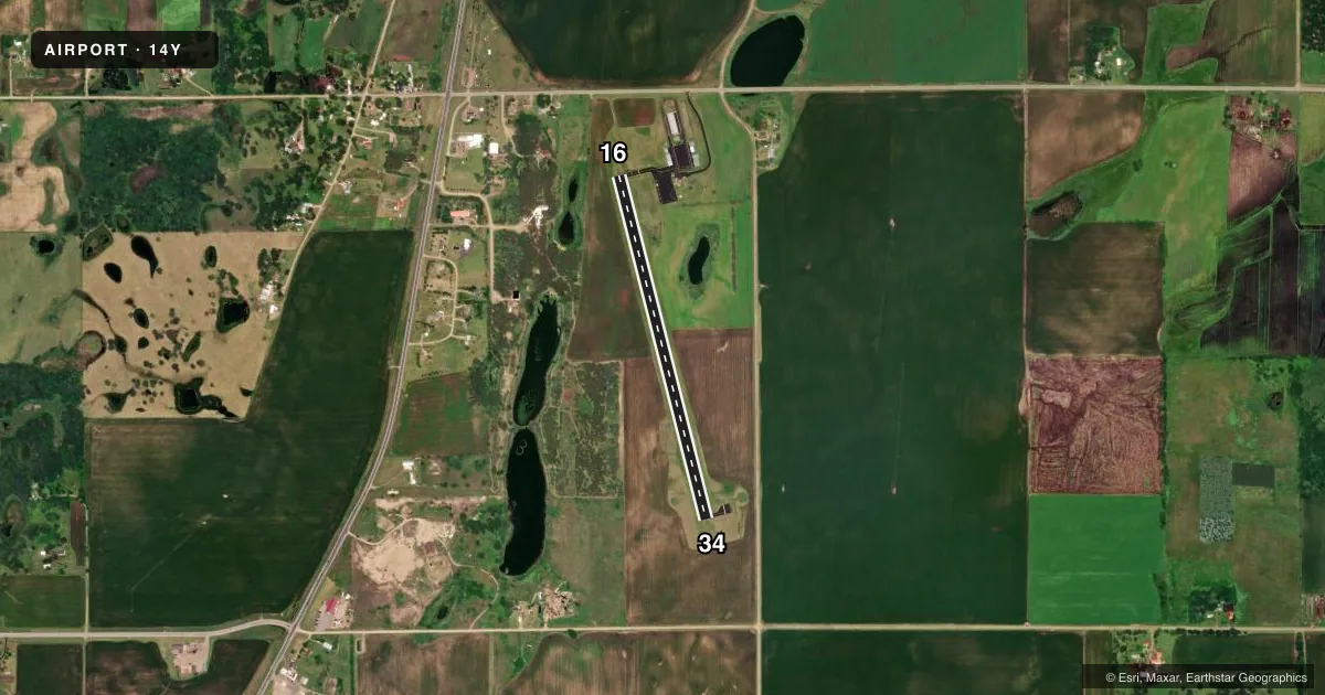
Airport sketch
Runways drawn to scale from FAA survey coordinates, rendered over satellite imagery. Not for navigation.
Approaches & charts
Services on the field
Fuel grades, oxygen, maintenance, ramp storage and lighting — as declared to the FAA by the airport operator.
Fuel & services
- Fuel
- 100LL
- Oxygen (bottled)
- Not available
- Oxygen (bulk)
- Not available
- Airframe repair
- Not available
- Power plant repair
- Not available
Ramp & ground
- Transient storage
- Tie-down
- Hangar
- Landing fee
- No fee published
- Customs
- Not available
- Lighting schedule
- SEE RMK
- Beacon schedule
- SS-SR
- Beacon
- White / Green (civil land)(WG)
- Wind indicator
- Lighted
- Segmented circle
- No
Fuel & FBOs
Cheapest 100LL and Jet A on the field and nearby. Always confirm with the FBO before taxi.
Airport notes
Surface conditions, obstructions, local procedures, lighting outages and other notes published with each FAA cycle.
General notes
- ULTRALIGHTS ON & INVOF ARPT.
- FOR CD CTC MINNEAPOLIS ARTCC AT 651-463-5588.
Lighting notes
- ACTVT REIL RWY 16 & 34; PAPI RWY 16 & 34; MIRL RWY 16/34 - CTAF. MIRL CONS SS - SR.
Fuel notes
- 100LL24 HR SELF SVC FUEL AVBL WITH CREDIT CARD.
Other notes
- HANGAR AVBL CALL (320) 732-2167.
- 2ON SITE GROUNDS KEEPER
- MANAGERLOCAL POLICE DESK AFT HRS.
VFR map & nearby airports
VFR sectional. Tap any ICAO chip to open that airport.
Key facts · 14Y
Answer card- ICAO
- 14Y
- Name
- TODD FLD
- Location
- LONG PRAIRIE, MINNESOTA
- Elevation
- 1,331.8 ft MSL
- Traffic pattern altitude
- 2,331.8 ft MSL (1,000 AGL)
- Control tower
- Non-towered (use CTAF)
- Total runways
- 1
- Longest runway
- 16/34 · 3,501 ft
- Published ILS approaches
- 0
- Published frequencies
- 1
- Magnetic variation
- 2°
- Current flight rules
- VFR
- Current wind
- 330° at 7 kt
- Favored runway now
- RWY 34
Todd Fld (14Y) sits in Long Prairie, Minnesota. Field elevation is 1,331.8 ft MSL. The airport has one runway. Runway 16/34 is 3,501 ft long with an asphalt surface. There is no control tower. CTAF is 122.9.
No ILS approaches are published here. The pattern altitude is not published, so use the standard 1,000 ft AGL for light piston traffic unless the current Chart Supplement says otherwise. Runway end identifier lights are installed on 16 and 34. Medium intensity runway lights are also installed on 16/34. They are controlled on CTAF and operate from sunset to sunrise. Precision approach path indicators are installed on both runway ends.
Todd Field is on the field and carries 100LL. 24-hour self-service fuel is available with a credit card. Hangars are available. Call the field at (320) 732-2167 if you need current details. Ultralight aircraft operate on and near the airport, so keep your scan active in the pattern and on taxi. For clearance delivery, Minneapolis ARTCC can be reached at 651-463-5588. If you need current airspace, noise, or operating restrictions, check the current FAA Chart Supplement before you go.