METAR & TAF KMOX
Current METAR
Observed 22:55Z
KMOX 272255Z AUTO 35007G13KT 10SM CLR 30/24 A2978 RMK AO2 TSNO
- Wind
- 350° @ 7G13 kt
- Visibility
- 10 SM
- Temp / Dew
- 30°C / 24°C
- Altimeter
- 29.78 inHg
- Clouds
- CLR
- Density alt
- 3,382 ft
- Ceiling
- Unlimited
- Rules
- VFR
Airport info & contacts
Manager on record, flight service, ARTCC, attendance schedule and pattern altitude — published by the FAA and refreshed every 28 days.
Location
- From city
- 3 NM SW
- VFR sectional
- TWIN CITIES
- ARTCC
- ZMP · MINNEAPOLIS
- NOTAM facility
- MOX (NOTAM-D)
Airport manager
- Name
- THOMAS KLOOS
- Phone
- 320-589-2083
- Address
- 50725 STATE HIGHWAY 28, MORRIS MN 56267-4412
Flight service · Hours
- FSS PNM
- PRINCETON1-800-WX-BRIEF
- Attendance
- MON-FRI · 0800-1400
Frequencies
Tap any row to copy the frequency to your clipboard.
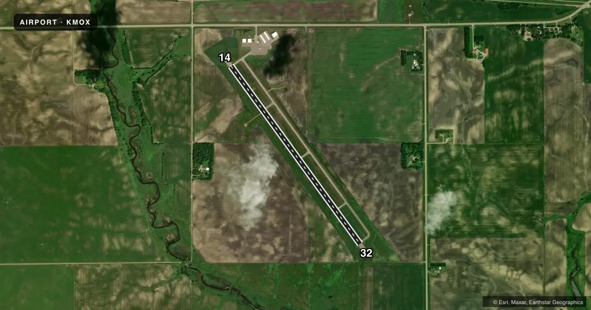
Runways & pattern
Full pagePattern entry · RWY 32
LEFT TRAFFICRunway end performance
| End | TORA | TODA | ASDA | LDA | VGSI | Approach lights | Obstruction |
|---|---|---|---|---|---|---|---|
| 14 | — | — | — | — | PAPI 4-box left(3°) | — | — |
| 32 | — | — | — | — | PAPI 4-box left(3°) | — | — |
Declared distances in feet. TORA = takeoff run available, TODA = takeoff distance, ASDA = accelerate-stop, LDA = landing distance.
Airport sketch
Runways drawn to scale from FAA survey coordinates, rendered over satellite imagery. Not for navigation.
Approaches & charts
Services on the field
Fuel grades, oxygen, maintenance, ramp storage and lighting — as declared to the FAA by the airport operator.
Fuel & services
- Fuel
- 100LLA
- Oxygen (bottled)
- Not available
- Oxygen (bulk)
- Not available
- Airframe repair
- Not available
- Power plant repair
- Not available
- Other services
- SALES
Ramp & ground
- Transient storage
- Tie-down
- Hangar
- Landing fee
- No fee published
- Customs
- Not available
- Lighting schedule
- SEE RMK
- Beacon schedule
- SS-SR
- Beacon
- White / Green (civil land)(WG)
- Wind indicator
- Lighted
- Segmented circle
- No
Fuel & FBOs
Cheapest 100LL and Jet A on the field and nearby. Always confirm with the FBO before taxi.
Airport notes
Surface conditions, obstructions, local procedures, lighting outages and other notes published with each FAA cycle.
General notes
- DEER & WATERFOWL ON & INVOF ARPT.
- FLD CONDS NOT UPDTD NGTS & WKENDS DURG WINTER MONTHS.
- TRML BLDG ACES: 3-2-1-4.
- FOR CD IF UNA TO CTC ON FSS FREQ, CTC MINNEAPOLIS ARTCC AT 651-463-5588.
Lighting notes
- ACTVT OR INCR INTST REIL RWY 14 & 32; PAPI RWY 14 & 32; HIRL RWY 14/32 - CTAF. HIRL RWY 14/32 PRESET LOW INTST.
Fuel notes
- 100LLFUEL AVBL H24 VIA CREDIT CARD.
Other notes
- FOR TSNT HNGR CALL AMGR, AFT HRS CALL DISPATCH 320-208-6500.
- MANAGERCELL 320-287-1645.
- OWNERAFT HRS CALL DISPATCH 320-208-6500.
VFR map & nearby airports
VFR sectional. Tap any ICAO chip to open that airport.
Key facts · KMOX
Answer card- ICAO
- KMOX
- Name
- MORRIS MUNI/CHARLIE SCHMIDT FLD
- Location
- MORRIS, MINNESOTA
- Elevation
- 1,135.9 ft MSL
- Traffic pattern altitude
- 2,135.9 ft MSL (1,000 AGL)
- Control tower
- Non-towered (use CTAF)
- Total runways
- 1
- Longest runway
- 14/32 · 4,899 ft
- Published ILS approaches
- 0
- Published frequencies
- 2
- Magnetic variation
- 2°
- Current flight rules
- VFR
- Current wind
- 350° at 7 kt
- Favored runway now
- RWY 32
Morris Muni/Charlie Schmidt Fld sits in Morris, Minnesota. The field elevation is 1,135.9 ft MSL. It has one runway, 14/32, which is 4,899 ft long. There is no control tower. CTAF and UNICOM are both 122.8. No ILS approaches are published here.
The published pattern altitude is not listed, so use the standard 1,000 ft AGL for light piston traffic unless the current FAA Chart Supplement says otherwise. The airport has one on-field FBO listed as Morris Municipal Airport. It carries AVGAS 100LL and JET A. 100LL is available 24 hours via credit card. The runway lighting is pilot-controlled on CTAF. PAPI is installed on both runway ends. Runway end identifier lights are also published for 14 and 32.
For a first-time arrival, watch the field conditions closely in winter. Published remarks say they are not updated nights and weekends during winter months. Deer and waterfowl are also reported on and near the airport. If you need transient hangar space, call the airport manager first. After hours, use the dispatch number in the Chart Supplement. Clearance delivery contact details are also published there if Flight Service cannot help.