METAR & TAF D32
D32 does not publish a METAR.
Showing the nearest reporting station: KGHW (GLENWOOD MUNI) · 9.4 NM away. Conditions at D32 may differ.
METAR · KGHW
Observed 18:55Z
KGHW 271855Z AUTO 31011KT 10SM CLR 30/24 A2981 RMK AO2 T03000242
- Wind
- 310° @ 11 kt
- Visibility
- 10 SM
- Temp / Dew
- 30°C / 24°C
- Altimeter
- 29.81 inHg
- Clouds
- CLR
- Density alt
- 3,350 ft
- Ceiling
- Unlimited
- Rules
- VFR
Airport info & contacts
Manager on record, flight service, ARTCC, attendance schedule and pattern altitude — published by the FAA and refreshed every 28 days.
Location
- From city
- 1 NM S
- VFR sectional
- TWIN CITIES
- ARTCC
- ZMP · MINNEAPOLIS
- NOTAM facility
- PNM (NOTAM-D)
Airport manager
- Name
- TOM BEUCKENS
- Phone
- 320-239-2525
- Address
- 307 5TH STREET, PO BOX 606, PO BOX 606, STARBUCK MN 56381
Flight service · Hours
- FSS PNM
- PRINCETON1-800-WX-BRIEF
- Attendance
- Unattended
Frequencies
Tap any row to copy the frequency to your clipboard.
Runways & pattern
Full pagePattern entry · RWY 33
LEFT TRAFFICRunway end performance
| End | TORA | TODA | ASDA | LDA | VGSI | Approach lights | Obstruction |
|---|---|---|---|---|---|---|---|
| 15 | — | — | — | — | — | — | 4', brush, 4' from thr, 69' R of cntrln, slope 0 |
| 33 | — | — | — | — | — | — | 4', brush, 4' from thr, 5' R of cntrln, slope 1 |
Declared distances in feet. TORA = takeoff run available, TODA = takeoff distance, ASDA = accelerate-stop, LDA = landing distance.
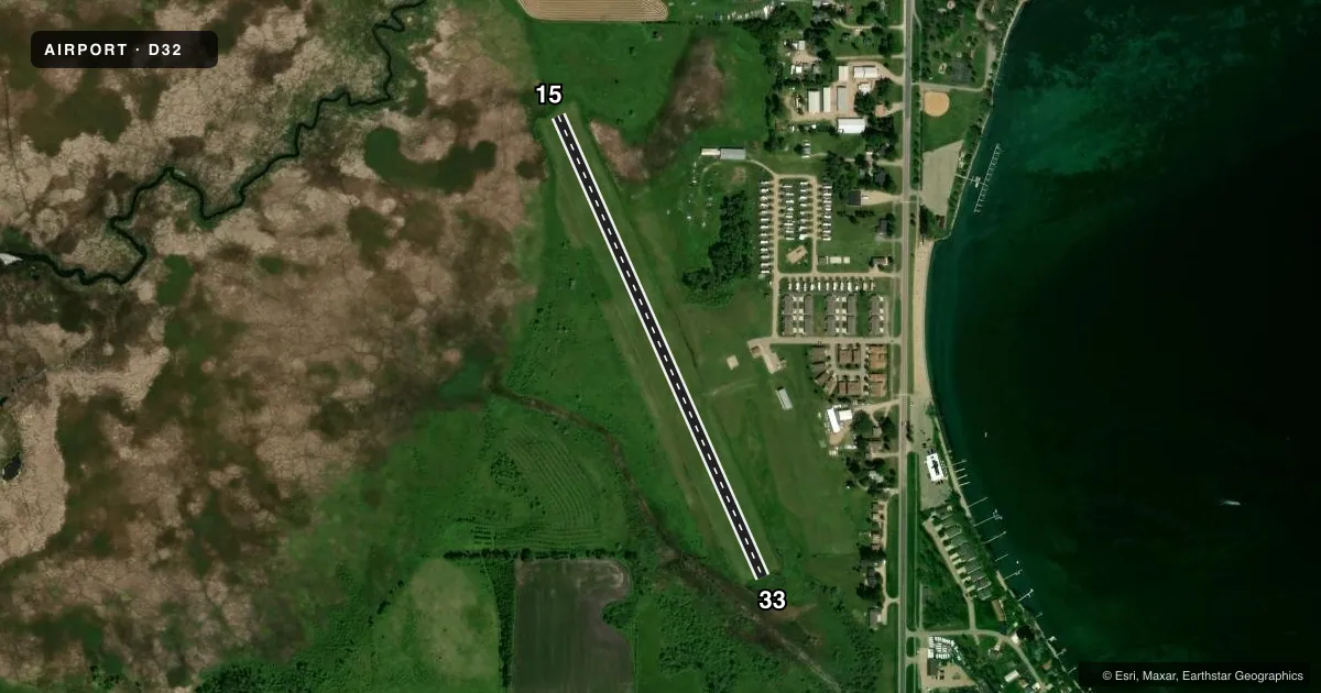
Airport sketch
Runways drawn to scale from FAA survey coordinates, rendered over satellite imagery. Not for navigation.
Approaches & charts
Services on the field
Fuel grades, oxygen, maintenance, ramp storage and lighting — as declared to the FAA by the airport operator.
Fuel & services
- Fuel
- Not available
- Oxygen (bottled)
- Not available
- Oxygen (bulk)
- Not available
- Airframe repair
- Not available
- Power plant repair
- Not available
Ramp & ground
- Transient storage
- Tie-down
- Landing fee
- No fee published
- Lighting schedule
- SEE RMK
- Beacon schedule
- SS-SR
- Beacon
- White / Green (civil land)(WG)
- Wind indicator
- Lighted
- Segmented circle
- No
Fuel & FBOs
Cheapest 100LL and Jet A on the field and nearby. Always confirm with the FBO before taxi.
Airport notes
Surface conditions, obstructions, local procedures, lighting outages and other notes published with each FAA cycle.
General notes
- FOR CD CTC MINNEAPOLIS ARTCC AT 651-463-5588.
- RWY 15 & 33 REIL & RWY 15 THR LGTS OBSC BY BRUSH.
Lighting notes
- ACTVT NSTD LIRL RWY 15/33 - CTAF.
Runway surface & condition
- 15/33NSTD LIRL DUE TO SPACING.
Approach & departure obstructions
- 15YELLOW CONES.
- 33YELLOW CONES.
VFR map & nearby airports
VFR sectional. Tap any ICAO chip to open that airport.
Key facts · D32
Answer card- ICAO
- D32
- Name
- STARBUCK MUNI
- Location
- STARBUCK, MINNESOTA
- Elevation
- 1,140.3 ft MSL
- Traffic pattern altitude
- 2,140.3 ft MSL (1,000 AGL)
- Control tower
- Non-towered (use CTAF)
- Total runways
- 1
- Longest runway
- 15/33 · 2,512 ft
- Published ILS approaches
- 0
- Published frequencies
- 1
- Magnetic variation
- 5°
- Current flight rules
- VFR
- Current wind
- 310° at 11 kt
- Favored runway now
- RWY 33
Starbuck Muni (D32) sits in Starbuck, Minnesota. Field elevation is 1,140.3 ft MSL. The airport has one runway, 15/33, which is 2,512 ft long and turf. There is no control tower. CTAF is 122.9. No ILS approaches are published here. Pattern altitude is not published, so use the standard 1,000 ft AGL for light piston traffic unless the current FAA Chart Supplement says otherwise.
The published remarks matter here. Runway 15/33 has nonstandard low intensity runway lights. They are activated by CTAF. Yellow cones mark the ends of both runway directions. Runway end identifier lights are installed. The threshold lights for runway 15 are obscured by brush, so plan your arrival with that in mind. For clearance delivery, contact Minneapolis ARTCC at 651-463-5588.
There are no on-field FBOs listed in the facts. FBO options vary. Contact the airport operator directly before arrival, or call the field on CTAF for current FBO availability. For a first look, this is a small turf field with one runway and no published instrument approach. Check the current FAA Chart Supplement for any local restrictions or updated lighting notes before you go.