METAR & TAF KGHW
Current METAR
Observed 00:35Z
KGHW 280035Z AUTO 31008KT 10SM CLR 29/24 A2983 RMK AO2 T02870236
- Wind
- 310° @ 8 kt
- Visibility
- 10 SM
- Temp / Dew
- 29°C / 24°C
- Altimeter
- 29.83 inHg
- Clouds
- CLR
- Density alt
- 3,520 ft
- Ceiling
- Unlimited
- Rules
- VFR
Airport info & contacts
Manager on record, flight service, ARTCC, attendance schedule and pattern altitude — published by the FAA and refreshed every 28 days.
Location
- From city
- 3 NM E
- VFR sectional
- TWIN CITIES
- ARTCC
- ZMP · MINNEAPOLIS
- NOTAM facility
- GHW (NOTAM-D)
Airport manager
- Name
- DAVID IVERSON
- Phone
- 320-634-5433
- Address
- 137 E. MINNESOTA AVE, GLENWOOD MN 56334
Flight service · Hours
- FSS PNM
- PRINCETON1-800-WX-BRIEF
- Attendance
- MON-FRI · 0800-1530
Frequencies
Tap any row to copy the frequency to your clipboard.
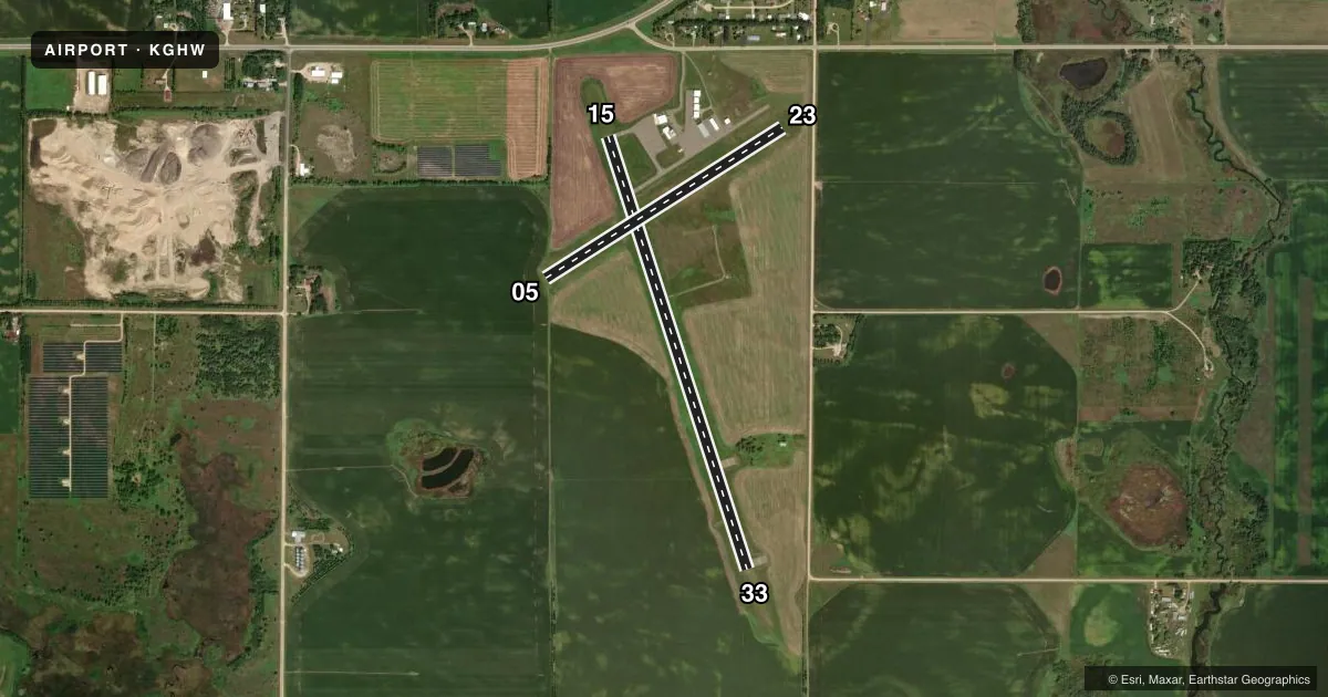
Runways & pattern
Full pagePattern entry · RWY 33
LEFT TRAFFIC| Runway | Heading (°M) | Length | Surface | Traffic |
|---|---|---|---|---|
| 15/33Favored | 158° / 338° | 4,500 ft | ASPH | Standard L |
| 05/23 | 54° / 234° | 2,778 ft | TURF | Standard L |
Runway end performance
| End | TORA | TODA | ASDA | LDA | VGSI | Approach lights | Obstruction |
|---|---|---|---|---|---|---|---|
| 15 | — | — | — | — | PAPI 4-box left(3°) | — | — |
| 33 | — | — | — | — | PAPI 4-box left(3°) | — | — |
| 05 | — | — | — | — | — | — | 8', other, 139' from thr, 78' R of cntrln, slope 17 |
Declared distances in feet. TORA = takeoff run available, TODA = takeoff distance, ASDA = accelerate-stop, LDA = landing distance.
Airport sketch
Runways drawn to scale from FAA survey coordinates, rendered over satellite imagery. Not for navigation.
Approaches & charts
Services on the field
Fuel grades, oxygen, maintenance, ramp storage and lighting — as declared to the FAA by the airport operator.
Fuel & services
- Fuel
- 100LL
- Oxygen (bottled)
- Not available
- Oxygen (bulk)
- Not available
- Airframe repair
- Not available
- Power plant repair
- Not available
- Other services
- AVNCS,SALES
Ramp & ground
- Transient storage
- Tie-down
- Hangar
- Landing fee
- No fee published
- Customs
- Not available
- Lighting schedule
- SEE RMK
- Beacon schedule
- SS-SR
- Beacon
- White / Green (civil land)(WG)
- Wind indicator
- Lighted
- Segmented circle
- No
Fuel & FBOs
Cheapest 100LL and Jet A on the field and nearby. Always confirm with the FBO before taxi.
Airport notes
Surface conditions, obstructions, local procedures, lighting outages and other notes published with each FAA cycle.
General notes
- RY 05/23 NOT PLOWED WINTER MONTHS.
- DEER ON & INVOF ARPT.
- GCO AVBL ON FREQ 121.725 THRU MINNEAPOLIS ARTCC & FLT SVCS.
- FOR CD IF UNA VIA GCO CTC MINNEAPOLIS ARTCC AT 651-463-5588.
Lighting notes
- MIRL RY 15/33 PRESET LOW INTST; TO INCREASE INTST AND ACTIVATE PAPI RY 15 AND 33 - CTAF.
Fuel notes
- 100LLSELF SVC FUEL AVBL 24 HR WITH CREDIT CARD.
Approach & departure obstructions
- 05RWY 05-23 MARKED WITH YELLOW CONES
- 05IRRIGATION BOOM.
VFR map & nearby airports
VFR sectional. Tap any ICAO chip to open that airport.
Key facts · KGHW
Answer card- ICAO
- KGHW
- Name
- GLENWOOD MUNI
- Location
- GLENWOOD, MINNESOTA
- Elevation
- 1,393.9 ft MSL
- Traffic pattern altitude
- 2,393.9 ft MSL (1,000 AGL)
- Control tower
- Non-towered (use CTAF)
- Total runways
- 2
- Longest runway
- 15/33 · 4,500 ft
- Published ILS approaches
- 0
- Published frequencies
- 1
- Magnetic variation
- 4°
- Current flight rules
- VFR
- Current wind
- 310° at 8 kt
- Favored runway now
- RWY 33
Glenwood Muni sits in Glenwood, Minnesota. Field elevation is 1,393.9 ft MSL. The airport has two runways. The longest is runway 15/33 at 4,500 ft asphalt. Runway 05/23 is 2,778 ft turf. There is no control tower. CTAF is 122.9.
No ILS approaches are published here. Pattern altitude is not published in the facts, so use standard light-piston pattern planning at 1,000 ft AGL and verify the current Chart Supplement before you go. The field has one on-field FBO, Glenwood Municipal Airport. It carries 100LL. Self-service fuel is available 24 hours with credit card.
A few operational items matter here. Runway 05/23 is not plowed in winter. There is an irrigation boom obstruction near runway 05. Deer are reported on and near the airport. Runway 15/33 has medium intensity lights preset to low intensity. Use the CTAF to increase intensity and activate the PAPI on runways 15 and 33. For clearance delivery, if you cannot get it through the ground communications outlet, contact Minneapolis ARTCC. The field also has a ground communications outlet on 121.725 through Minneapolis ARTCC and flight services. Check the current Chart Supplement for any published noise or curfew restrictions before flying into the field.