METAR & TAF KLJF
Current METAR
Observed 23:15Z
KLJF 272315Z AUTO 32007KT 10SM CLR 32/22 A2976 RMK AO2
- Wind
- 320° @ 7 kt
- Visibility
- 10 SM
- Temp / Dew
- 32°C / 22°C
- Altimeter
- 29.76 inHg
- Clouds
- CLR
- Density alt
- 3,652 ft
- Ceiling
- Unlimited
- Rules
- VFR
Airport info & contacts
Manager on record, flight service, ARTCC, attendance schedule and pattern altitude — published by the FAA and refreshed every 28 days.
Location
- From city
- 2 NM SE
- VFR sectional
- TWIN CITIES
- ARTCC
- ZMP · MINNEAPOLIS
- NOTAM facility
- LJF (NOTAM-D)
Airport manager
- Name
- MIKE GEERS
- Phone
- (320) 693-7201
- Address
- 703 PARK AVE., LITCHFIELD MN 55355
Flight service · Hours
- FSS PNM
- PRINCETON1-800-WX-BRIEF
- Attendance
- Unattended
Frequencies
Tap any row to copy the frequency to your clipboard.
Runways & pattern
Full pagePattern entry · RWY 31
LEFT TRAFFICRunway end performance
| End | TORA | TODA | ASDA | LDA | VGSI | Approach lights | Obstruction |
|---|---|---|---|---|---|---|---|
| 13 | — | — | — | — | PAPI 4-box left(3°) | — | — |
| 31 | — | — | — | — | PAPI 4-box left(3°) | — | — |
Declared distances in feet. TORA = takeoff run available, TODA = takeoff distance, ASDA = accelerate-stop, LDA = landing distance.
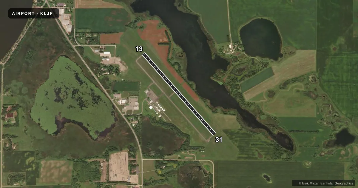
Airport sketch
Runways drawn to scale from FAA survey coordinates, rendered over satellite imagery. Not for navigation.
Approaches & charts
Services on the field
Fuel grades, oxygen, maintenance, ramp storage and lighting — as declared to the FAA by the airport operator.
Fuel & services
- Fuel
- 100LL
- Other services
- SALES
Ramp & ground
- Transient storage
- Tie-down
- Lighting schedule
- SEE RMK
- Beacon schedule
- SS-SR
- Beacon
- White / Green (civil land)(WG)
- Wind indicator
- Lighted
- Segmented circle
- No
Fuel & FBOs
Cheapest 100LL and Jet A on the field and nearby. Always confirm with the FBO before taxi.
Airport notes
Surface conditions, obstructions, local procedures, lighting outages and other notes published with each FAA cycle.
General notes
- TRSNL SFC OBSTN - TREES - NORTHEAST OF RY 13/31.
- FOR CD CTC MINNEAPOLIS ARTCC AT 651-463-5588.
Lighting notes
- MIRL RY 13/31 PRESET ON LOW INTST, TO INCR INTST AND ACTVT REIL RY 13/ 31; PAPI RY 13/31 - CTAF.
Fuel notes
- 100LLSELF SVC FUEL AVBL 24 HRS WITH CREDIT CARD.
VFR map & nearby airports
VFR sectional. Tap any ICAO chip to open that airport.
Key facts · KLJF
Answer card- ICAO
- KLJF
- Name
- LITCHFIELD MUNI
- Location
- LITCHFIELD, MINNESOTA
- Elevation
- 1,139.9 ft MSL
- Traffic pattern altitude
- 2,139.9 ft MSL (1,000 AGL)
- Control tower
- Non-towered (use CTAF)
- Total runways
- 1
- Longest runway
- 13/31 · 4,002 ft
- Published ILS approaches
- 0
- Published frequencies
- 1
- Magnetic variation
- 2°
- Current flight rules
- VFR
- Current wind
- 320° at 7 kt
- Favored runway now
- RWY 31
Litchfield Muni sits in Litchfield, Minnesota. The field elevation is 1,139.9 ft MSL. It has one runway. Runway 13/31 is 4,002 ft long with an asphalt surface. There is no control tower. CTAF is 122.9. No ILS approaches are published here.
Pattern altitude is not published in the facts. Use the standard 1,000 ft AGL unless the current Chart Supplement says otherwise. The on-field FBO is Litchfield Municipal Airport. It carries 100LL and Jet A. Self-serve 100LL is available 24 hours with a credit card. The airport also notes that runway 13/31 lights are preset on low intensity. Use CTAF to raise the intensity or turn on runway end identifier lights.
First-time pilots should also watch the trees northeast of runway 13/31. That obstruction is called out in the published remarks. For clearance delivery, Minneapolis ARTCC is listed as the contact. Check the current Chart Supplement for any noise or operating notes before you go. With no tower and one short field by airline standards, this is a straightforward local airport. Still, the elevation and the Minnesota weather can make performance planning matter on warm days.