METAR & TAF 10D
10D does not publish a METAR.
Showing the nearest reporting station: KGYL (GLENCOE MUNI) · 11.9 NM away. Conditions at 10D may differ.
METAR · KGYL
Observed 17:15Z
KGYL 271715Z AUTO 30008KT 10SM CLR 30/24 A2976 RMK AO2 T02980238
- Wind
- 300° @ 8 kt
- Visibility
- 10 SM
- Temp / Dew
- 30°C / 24°C
- Altimeter
- 29.76 inHg
- Clouds
- CLR
- Density alt
- 3,276 ft
- Ceiling
- Unlimited
- Rules
- VFR
Airport info & contacts
Manager on record, flight service, ARTCC, attendance schedule and pattern altitude — published by the FAA and refreshed every 28 days.
Location
- From city
- 1 NM SW
- VFR sectional
- TWIN CITIES
- ARTCC
- ZMP · MINNEAPOLIS
- NOTAM facility
- PNM (NOTAM-D)
Airport manager
- Name
- DAVID MEYER
- Phone
- 320-485-2201
- Address
- PO BOX 126, WINSTED MN 55395-0126
Flight service · Hours
- FSS PNM
- PRINCETON1-800-WX-BRIEF
- Attendance
- Unattended
Frequencies
Tap any row to copy the frequency to your clipboard.
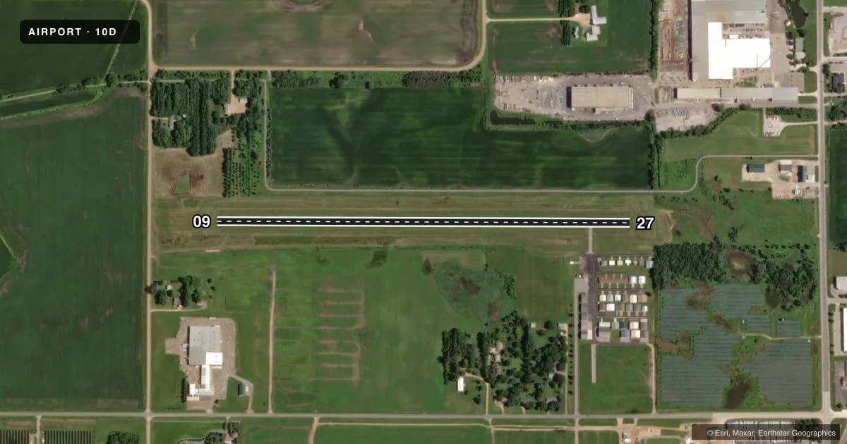
Runways & pattern
Full pagePattern entry · RWY 27
LEFT TRAFFICRunway end performance
| End | TORA | TODA | ASDA | LDA | VGSI | Approach lights | Obstruction |
|---|---|---|---|---|---|---|---|
| 09 | — | — | — | — | — | — | 16', road, 530' from thr, 0' R of cntrln, slope 33 |
| 27 | — | — | — | — | — | — | 54', trees, 666' from thr, 159' R of cntrln, slope 12 |
Declared distances in feet. TORA = takeoff run available, TODA = takeoff distance, ASDA = accelerate-stop, LDA = landing distance.
Airport sketch
Runways drawn to scale from FAA survey coordinates, rendered over satellite imagery. Not for navigation.
Approaches & charts
Services on the field
Fuel grades, oxygen, maintenance, ramp storage and lighting — as declared to the FAA by the airport operator.
Fuel & services
- Fuel
- 100LL
- Oxygen (bottled)
- Not available
- Oxygen (bulk)
- Not available
- Airframe repair
- Not available
- Power plant repair
- Not available
- Other services
- PAJA,SALES
Ramp & ground
- Transient storage
- Tie-down
- Landing fee
- No fee published
- Customs
- Not available
- Lighting schedule
- SS-SR
- Beacon schedule
- SS-SR
- Beacon
- White / Green (civil land)(WG)
- Wind indicator
- Lighted
- Segmented circle
- No
Fuel & FBOs
Cheapest 100LL and Jet A on the field and nearby. Always confirm with the FBO before taxi.
Airport notes
Surface conditions, obstructions, local procedures, lighting outages and other notes published with each FAA cycle.
General notes
- ULTRALIGHT ACT ON & INVOF ARPT IN LWR PAT.
- PAJA ON FLD.
- FOR CD CTC MINNEAPOLIS APCH AT 612-713-4016.
Fuel notes
- 100LLFUEL AVBL H24 VIA CREDIT CARD.
Runway surface & condition
- 09/27SVRL BKN OR BENT OVR.
Approach & departure obstructions
- 09YELLOW CONES.
- 27YELLOW CONES.
Other notes
- MANAGEROR 612-986-2184.
VFR map & nearby airports
VFR sectional. Tap any ICAO chip to open that airport.
Key facts · 10D
Answer card- ICAO
- 10D
- Name
- WINSTED MUNI
- Location
- WINSTED, MINNESOTA
- Elevation
- 1,030 ft MSL
- Traffic pattern altitude
- 2,030 ft MSL (1,000 AGL)
- Control tower
- Non-towered (use CTAF)
- Total runways
- 1
- Longest runway
- 09/27 · 3,248 ft
- Published ILS approaches
- 0
- Published frequencies
- 1
- Magnetic variation
- 4°
- Current flight rules
- VFR
- Current wind
- 300° at 8 kt
- Favored runway now
- RWY 27
Winsted Muni sits in Winsted, Minnesota. The field elevation is 1,030 ft MSL. It has one runway, 09/27, which is 3,248 ft of turf. There is no control tower. CTAF is 122.9. No ILS approaches are published here.
Pattern altitude is not published. Use the standard 1,000 ft AGL for light piston traffic unless local guidance says otherwise. That puts the pattern at 2,030 ft MSL. Runway 09 and runway 27 both have yellow cones marking the ends. Several runway lights on 09/27 are broken or bent over, so plan your arrival with that in mind if you are coming in near dusk or after dark.
There are no on-field FBOs listed. 100LL is available 24 hours a day through credit card self-service. The airport manager can be reached at 612-986-2184. A parachute jumping area is on the field. Ultralights are active on and near the airport in the lower traffic pattern, so keep your scan tight in the pattern and on final. For clearance delivery, contact Minneapolis Approach at 612-726-9086. If you need current noise, operating, or access details before you go, check the current FAA Chart Supplement or call the airport operator directly.