METAR & TAF 1D6
1D6 does not publish a METAR.
Showing the nearest reporting station: KOVL (OLIVIA RGNL) · 13.9 NM away. Conditions at 1D6 may differ.
METAR · KOVL
Observed 19:35Z
KOVL 271935Z AUTO 31009KT 10SM CLR 30/23 A2979 RMK AO2
- Wind
- 310° @ 9 kt
- Visibility
- 10 SM
- Temp / Dew
- 30°C / 23°C
- Altimeter
- 29.79 inHg
- Clouds
- CLR
- Density alt
- 3,298 ft
- Ceiling
- Unlimited
- Rules
- VFR
Airport info & contacts
Manager on record, flight service, ARTCC, attendance schedule and pattern altitude — published by the FAA and refreshed every 28 days.
Location
- From city
- 1 NM S
- VFR sectional
- TWIN CITIES
- ARTCC
- ZMP · MINNEAPOLIS
- NOTAM facility
- PNM (NOTAM-D)
Airport manager
- Name
- GINA SCHELLENBERG
- Phone
- 320-522-1966
- Address
- 78980 STATE HIGHWAY 4, HECTOR MN 55342-1235
Flight service · Hours
- FSS PNM
- PRINCETON1-800-WX-BRIEF
- Attendance
- Unattended
Frequencies
Tap any row to copy the frequency to your clipboard.
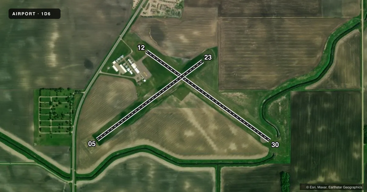
Runways & pattern
Full pagePattern entry · RWY 30
LEFT TRAFFIC| Runway | Heading (°M) | Length | Surface | Traffic |
|---|---|---|---|---|
| 12/30Favored | 122° / 302° | 2,776 ft | ASPH | Standard L |
| 05/23 | 49° / 229° | 2,395 ft | TURF | Standard L |
Runway end performance
| End | TORA | TODA | ASDA | LDA | VGSI | Approach lights | Obstruction |
|---|---|---|---|---|---|---|---|
| 12 | — | — | — | — | — | — | 17', road, 504' from thr, 150' R of cntrln, slope 17 |
| 05 | — | — | — | — | — | — | 19', road, 397' from thr, 0' R of cntrln, slope 20 |
| 23 | — | — | — | — | — | — | 5', crops, 96' from thr, 85' R of cntrln, slope 19 |
Declared distances in feet. TORA = takeoff run available, TODA = takeoff distance, ASDA = accelerate-stop, LDA = landing distance.
Airport sketch
Runways drawn to scale from FAA survey coordinates, rendered over satellite imagery. Not for navigation.
Approaches & charts
Services on the field
Fuel grades, oxygen, maintenance, ramp storage and lighting — as declared to the FAA by the airport operator.
Fuel & services
- Fuel
- 100LL
- Oxygen (bottled)
- Not available
- Oxygen (bulk)
- Not available
- Airframe repair
- Not available
- Power plant repair
- Not available
- Other services
- AGRI,SALES
Ramp & ground
- Transient storage
- Tie-down
- Landing fee
- No fee published
- Customs
- Not available
- Lighting schedule
- SS-SR
- Wind indicator
- Lighted
- Segmented circle
- No
Fuel & FBOs
Cheapest 100LL and Jet A on the field and nearby. Always confirm with the FBO before taxi.
Airport notes
Surface conditions, obstructions, local procedures, lighting outages and other notes published with each FAA cycle.
General notes
- +8 FT CROPS IN PRI SFC OF ALL RWYS.
- FOR CD CTC MINNEAPOLIS ARTCC AT 651-463-5588.
Fuel notes
- 100LLFUEL SVC CALL 320-848-2745.
Runway surface & condition
- 05/23NOT PLOWED WINTER MONTHS.
- 12/30LGTS MOUNTED IN YELLOW CONES.
Approach & departure obstructions
- 05YELLOW CONES.
- 23YELLOW CONES.
Other notes
- 1CALL 320-848-2745.
VFR map & nearby airports
VFR sectional. Tap any ICAO chip to open that airport.
Key facts · 1D6
Answer card- ICAO
- 1D6
- Name
- HECTOR MUNI
- Location
- HECTOR, MINNESOTA
- Elevation
- 1,078 ft MSL
- Traffic pattern altitude
- 2,078 ft MSL (1,000 AGL)
- Control tower
- Non-towered (use CTAF)
- Total runways
- 2
- Longest runway
- 12/30 · 2,776 ft
- Published ILS approaches
- 0
- Published frequencies
- 2
- Magnetic variation
- 4°
- Current flight rules
- VFR
- Current wind
- 310° at 9 kt
- Favored runway now
- RWY 30
Hector Muni sits in Hector, Minnesota. The field elevation is 1,078 ft MSL. It has two runways. The longest is 12/30 at 2,776 ft. There is no control tower. CTAF and UNICOM are both 122.8.
No ILS approaches are published here. The pattern altitude is not published, so use the standard 1,000 ft AGL for light piston operations unless the current Chart Supplement says otherwise. The on-field FBO is Hector Municipal Airport. It carries 100LL. Fuel service is available by calling 320-848-2745.
A few published remarks matter for planning. Runway 23 is marked with yellow cones. Runway 05 is also marked with yellow cones. The 12/30 lights are mounted in yellow cones. Runway 05/23 is not plowed during winter months. There are also 8-foot crops in the primary surface of all runways, so expect a field environment and keep an eye out on short final and rollout. For clearance delivery, Minneapolis ARTCC can be reached at 651-463-5588. If you are coming in for the first time, verify current runway condition and field status before departure. That is especially important here because the turf runway is shorter and winter use on 05/23 is limited.