METAR & TAF KULM
Current METAR
Observed 18:55Z
KULM 121855Z AUTO 27012G23KT 10SM SCT070 26/13 A2988 RMK AO2
- Wind
- 270° @ 12G23 kt
- Visibility
- 10 SM
- Temp / Dew
- 26°C / 13°C
- Altimeter
- 29.88 inHg
- Clouds
- SCT
- Density alt
- 2,623 ft
- Ceiling
- Unlimited
- Rules
- VFR
Airport info & contacts
Manager on record, flight service, ARTCC, attendance schedule and pattern altitude — published by the FAA and refreshed every 28 days.
Location
- From city
- 2 NM W
- VFR sectional
- OMAHA
- ARTCC
- ZMP · MINNEAPOLIS
- NOTAM facility
- ULM (NOTAM-D)
Airport manager
- Name
- JOSEPH STADHEIM
- Phone
- 507-233-2118
- Address
- 100 N BROADWAY ST, NEW ULM MN 56073-1795
Flight service · Hours
- FSS PNM
- PRINCETON1-800-WX-BRIEF
- Attendance
- MON-FRI · 0800-1700
Frequencies
Tap any row to copy the frequency to your clipboard.
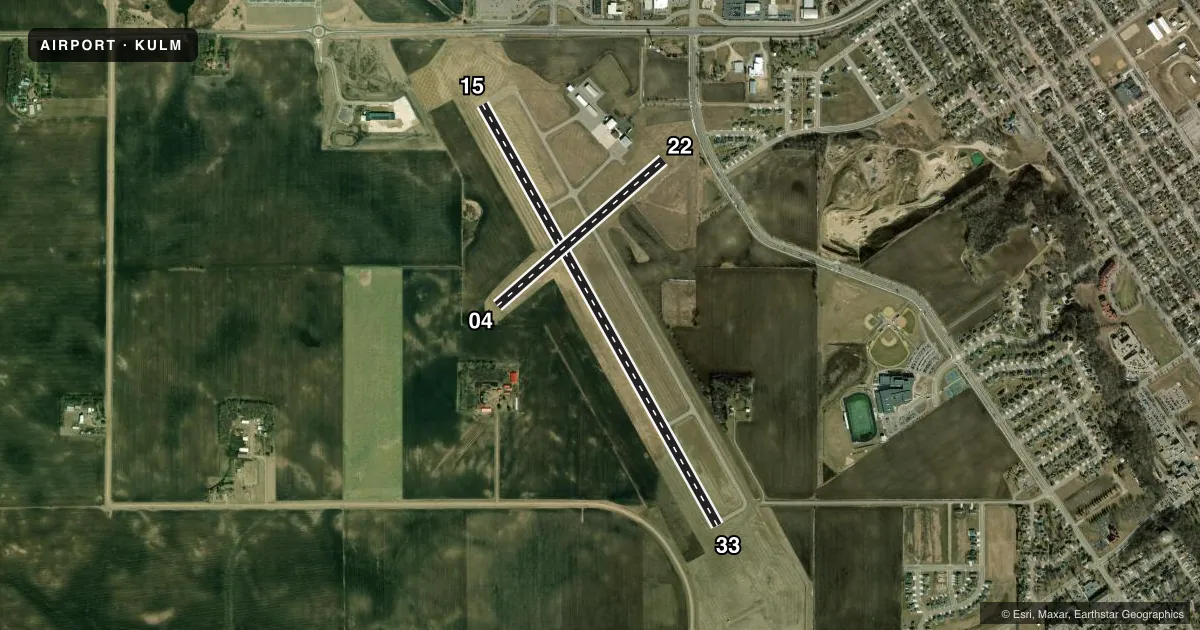
Runways & pattern
Full pagePattern entry · RWY 22
LEFT TRAFFIC| Runway | Heading (°M) | Length | Surface | Traffic |
|---|---|---|---|---|
| 15/33 | 150° / 330° | 5,401 ft | ASPH | Standard L |
| 04/22Favored | 48° / 228° | 2,478 ft | TURF | Standard L |
Runway end performance
| End | TORA | TODA | ASDA | LDA | VGSI | Approach lights | Obstruction |
|---|---|---|---|---|---|---|---|
| 15 | — | — | — | — | PAPI 4-box left(3°) | — | — |
| 33 | — | — | — | — | PAPI 4-box right(3°) | MALSF | — |
Declared distances in feet. TORA = takeoff run available, TODA = takeoff distance, ASDA = accelerate-stop, LDA = landing distance.
Airport sketch
Runways drawn to scale from FAA survey coordinates, rendered over satellite imagery. Not for navigation.
Approaches & charts
Services on the field
Fuel grades, oxygen, maintenance, ramp storage and lighting — as declared to the FAA by the airport operator.
Fuel & services
- Fuel
- 100LLA
- Oxygen (bottled)
- Not available
- Oxygen (bulk)
- Not available
- Airframe repair
- Major
- Power plant repair
- Major
Ramp & ground
- Transient storage
- Tie-down
- Hangar
- Landing fee
- No fee published
- Customs
- Not available
- Lighting schedule
- SEE RMK
- Beacon schedule
- SS-SR
- Beacon
- White / Green (civil land)(WG)
- Wind indicator
- Lighted
- Segmented circle
- No
Fuel & FBOs
Cheapest 100LL and Jet A on the field and nearby. Always confirm with the FBO before taxi.
Airport notes
Surface conditions, obstructions, local procedures, lighting outages and other notes published with each FAA cycle.
General notes
- GCO AVBL ON FREQ 121.725 THRU MINNEAPOLIS ARTCC & FLT SVCS.
- FOR CD IF UNA VIA GCO CTC MINNEAPOLIS ARTCC AT 651-463-5588.
Lighting notes
- ACTVT MALSF RWY 33; REIL RWY 15; PAPI RWY 15 & 33; MIRL RWY 15/33 - CTAF.
Fuel notes
- 100LLFUEL AVBL H24 VIA CREDIT CARD.
Runway surface & condition
- 04/22CLSD WINTER MONTHS.
Approach & departure obstructions
- 04YELLOW CONES.
- 22YELLOW CONES.
Other notes
- MANAGEROR 507-354-8127.
VFR map & nearby airports
VFR sectional. Tap any ICAO chip to open that airport.
Key facts · KULM
Answer card- ICAO
- KULM
- Name
- NEW ULM MUNI
- Location
- NEW ULM, MINNESOTA
- Elevation
- 1,011.2 ft MSL
- Traffic pattern altitude
- 2,011.2 ft MSL (1,000 AGL)
- Control tower
- Non-towered (use CTAF)
- Total runways
- 2
- Longest runway
- 15/33 · 5,401 ft
- Published ILS approaches
- 0
- Published frequencies
- 2
- Magnetic variation
- 1°
- Current flight rules
- VFR
- Current wind
- 270° at 12 kt
- Favored runway now
- RWY 22
New Ulm Muni (KULM) sits in New Ulm, Minnesota. Field elevation is 1,011.2 ft MSL. The airport has two runways. The longest is 15/33 at 5,401 ft asphalt. Runway 04/22 is 2,478 ft turf. There is no control tower. CTAF and UNICOM are both 123.0.
No ILS approaches are published here. Pattern altitude is not published, so use the standard 1,000 ft AGL for light piston traffic unless the current Chart Supplement says otherwise. That puts the pattern at about 2,011 ft MSL based on the field elevation. North Star Aviation is on the field. It carries 100LL and Jet A Prist. 100LL is available 24 hours a day by credit card.
A few runway notes matter here. Runway 33 has MALSF lighting. Runway 15 has runway end identifier lights. PAPI is published on 15 and 33. Yellow cones mark the ends of runway 04 and runway 22. Runway 04/22 is closed during winter months, so plan on 15/33 as the main paved option. The airport also has a ground communications outlet on 121.725 through Minneapolis ARTCC and flight services. If you need clearance delivery and cannot get it through the outlet, Minneapolis ARTCC is listed in the remarks. Check the current Chart Supplement for any other local procedures before you go.