METAR & TAF Y58
Y58 does not publish a METAR.
Showing the nearest reporting station: KULM (NEW ULM MUNI) · 9.9 NM away. Conditions at Y58 may differ.
METAR · KULM
Observed 23:15Z
KULM 272315Z AUTO 32008KT 10SM CLR 32/25 A2976 RMK AO2
- Wind
- 320° @ 8 kt
- Visibility
- 10 SM
- Temp / Dew
- 32°C / 25°C
- Altimeter
- 29.76 inHg
- Clouds
- CLR
- Density alt
- 3,486 ft
- Ceiling
- Unlimited
- Rules
- VFR
Airport info & contacts
Manager on record, flight service, ARTCC, attendance schedule and pattern altitude — published by the FAA and refreshed every 28 days.
Location
- From city
- 3 NM SE
- VFR sectional
- OMAHA
- ARTCC
- ZMP · MINNEAPOLIS
- NOTAM facility
- PNM (NOTAM-D)
Airport manager
- Name
- LARRY LUND
- Phone
- 507-794-7665
- Address
- 26227 200TH ST, SLEEPY EYE MN 56085-5118
Flight service · Hours
- FSS PNM
- PRINCETON1-800-WX-BRIEF
- Attendance
- Unattended
Frequencies
Tap any row to copy the frequency to your clipboard.
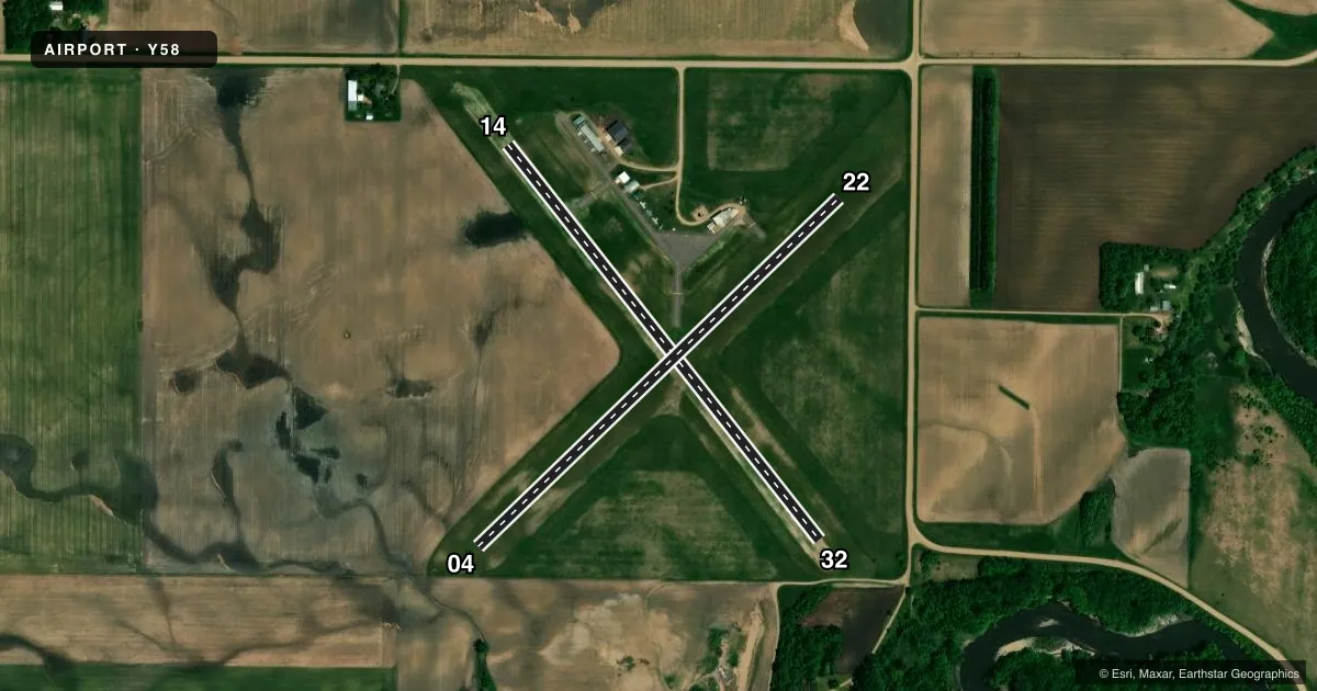
Runways & pattern
Full pagePattern entry · RWY 32
LEFT TRAFFIC| Runway | Heading (°M) | Length | Surface | Traffic |
|---|---|---|---|---|
| 14/32Favored | 138° / 318° | 2,575 ft | TURF | Standard L |
| 04/22 | 42° / 222° | 2,565 ft | TURF | Standard L |
Runway end performance
| End | TORA | TODA | ASDA | LDA | VGSI | Approach lights | Obstruction |
|---|---|---|---|---|---|---|---|
| 32 | — | — | — | — | — | — | 25', trees, 223' from thr, 142' R of cntrln, slope 8 |
| 04 | — | — | — | — | — | — | 9', crops, 99' from thr, 114' R of cntrln, slope 11 |
Declared distances in feet. TORA = takeoff run available, TODA = takeoff distance, ASDA = accelerate-stop, LDA = landing distance.
Airport sketch
Runways drawn to scale from FAA survey coordinates, rendered over satellite imagery. Not for navigation.
Approaches & charts
Services on the field
Fuel grades, oxygen, maintenance, ramp storage and lighting — as declared to the FAA by the airport operator.
Fuel & services
- Fuel
- Not available
- Oxygen (bottled)
- Not available
- Oxygen (bulk)
- Not available
- Airframe repair
- Not available
- Power plant repair
- Not available
- Other services
- AGRI
Ramp & ground
- Transient storage
- Tie-down
- Hangar
- Landing fee
- No fee published
- Customs
- Not available
- Lighting schedule
- SEE RMK
- Wind indicator
- Lighted
- Segmented circle
- No
Fuel & FBOs
Cheapest 100LL and Jet A on the field and nearby. Always confirm with the FBO before taxi.
Airport notes
Surface conditions, obstructions, local procedures, lighting outages and other notes published with each FAA cycle.
General notes
- SEWAGE DISPOSAL PONDS 1600 FT NORTH OF ARPT.
- AGRICULTURE OPS ON & INVOF ARPT JUN-SEP.
- FOR CD CTC MINNEAPOLIS ARTCC AT 651-463-5588.
Lighting notes
- ACTVT MIRL RWY 14/32 - CTAF.
Runway surface & condition
- 04/22NOT PLOWED WINTER MONTHS.
Approach & departure obstructions
- 04YELLOW CONES.
- 14YELLOW CONES.
- 22YELLOW CONES.
- 32YELLOW CONES.
- 32+15 FT ROAD, 195 FT DIST, 0 FT B, 13:1; STOP SIGNS AT RWY EDGES.
Other notes
- ESTABD BFR 1959
- MANAGERLTIEDEKEN@SLEEPYEYE-MN.COM.
VFR map & nearby airports
VFR sectional. Tap any ICAO chip to open that airport.
Key facts · Y58
Answer card- ICAO
- Y58
- Name
- SLEEPY EYE MUNI
- Location
- SLEEPY EYE, MINNESOTA
- Elevation
- 1,006 ft MSL
- Traffic pattern altitude
- 2,006 ft MSL (1,000 AGL)
- Control tower
- Non-towered (use CTAF)
- Total runways
- 2
- Longest runway
- 14/32 · 2,575 ft
- Published ILS approaches
- 0
- Published frequencies
- 1
- Magnetic variation
- 4°
- Current flight rules
- VFR
- Current wind
- 320° at 8 kt
- Favored runway now
- RWY 32
Sleepy Eye Muni sits in Sleepy Eye, Minnesota. Field elevation is 1,006 ft MSL. The airport has two turf runways. The longest is 2,575 ft. There is no control tower. CTAF is 122.9.
No ILS approaches are published here. Pattern altitude is not published, so use the standard 1,000 ft AGL for light piston traffic unless the current Chart Supplement says otherwise. That puts the pattern at about 2,006 ft MSL based on the field elevation. Runway 14/32 has medium intensity lighting that is activated on CTAF. Runways 04 and 22 are not plowed in winter. Yellow cones mark the runway ends on all four ends. There is also a 15-foot road obstruction near the runway 32 end, so give yourself a careful look on final and during rollout.
There are no on-field FBOs listed. Check with the airport operator or the FBO directly by phone for current services before you go. Agriculture operations occur on and near the airport from June through September. Sewage disposal ponds are 1,600 ft north of the field. For clearance delivery, Minneapolis ARTCC is listed in the Chart Supplement. This is a small non-towered turf airport, so expect to self-announce and keep an eye out for local traffic and seasonal ag activity.