METAR & TAF KOVL
Current METAR
Observed 18:15Z
KOVL 271815Z AUTO 30008KT 10SM CLR 29/23 A2979 RMK AO2
- Wind
- 300° @ 8 kt
- Visibility
- 10 SM
- Temp / Dew
- 29°C / 23°C
- Altimeter
- 29.79 inHg
- Clouds
- CLR
- Density alt
- 3,180 ft
- Ceiling
- Unlimited
- Rules
- VFR
Airport info & contacts
Manager on record, flight service, ARTCC, attendance schedule and pattern altitude — published by the FAA and refreshed every 28 days.
Location
- From city
- 2 NM W
- VFR sectional
- TWIN CITIES
- ARTCC
- ZMP · MINNEAPOLIS
- NOTAM facility
- OVL (NOTAM-D)
Airport manager
- Name
- RICHARD SIGURDSON
- Phone
- 320-523-2186
- Address
- PO BOX 169, OLIVIA MN 56277-0169
Flight service · Hours
- FSS PNM
- PRINCETON1-800-WX-BRIEF
- Attendance
- APR-OCT · 0800-1700
- NOV-MAR · MON-FRI · 0800-1700
- NOV-MAR · SAT · 0800-1200
Frequencies
Tap any row to copy the frequency to your clipboard.
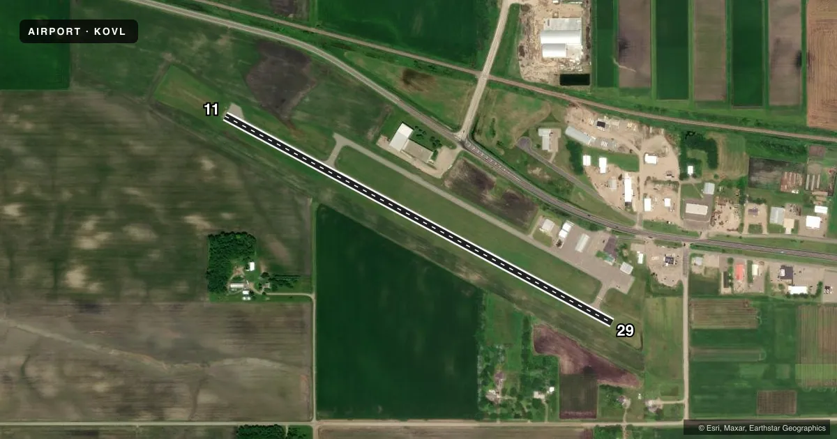
Runways & pattern
Full pagePattern entry · RWY 29
LEFT TRAFFICRunway end performance
| End | TORA | TODA | ASDA | LDA | VGSI | Approach lights | Obstruction |
|---|---|---|---|---|---|---|---|
| 11 | — | — | — | — | PAPI 2-box left(3°) | — | — |
| 29 | — | — | — | — | PAPI 2-box left(3°) | — | 19', brush, 422' from thr, 240' R of cntrln, slope 11 |
Declared distances in feet. TORA = takeoff run available, TODA = takeoff distance, ASDA = accelerate-stop, LDA = landing distance.
Airport sketch
Runways drawn to scale from FAA survey coordinates, rendered over satellite imagery. Not for navigation.
Approaches & charts
Services on the field
Fuel grades, oxygen, maintenance, ramp storage and lighting — as declared to the FAA by the airport operator.
Fuel & services
- Fuel
- 100LL
- Oxygen (bottled)
- Not available
- Oxygen (bulk)
- Not available
- Airframe repair
- Minor
- Power plant repair
- Major
- Other services
- AGRI,SALES
Ramp & ground
- Transient storage
- Tie-down
- Hangar
- Landing fee
- No fee published
- Lighting schedule
- SEE RMK
- Beacon schedule
- SS-SR
- Beacon
- White / Green (civil land)(WG)
- Wind indicator
- Lighted
- Segmented circle
- No
Fuel & FBOs
Cheapest 100LL and Jet A on the field and nearby. Always confirm with the FBO before taxi.
Airport notes
Surface conditions, obstructions, local procedures, lighting outages and other notes published with each FAA cycle.
General notes
- FOR CD CTC MINNEAPOLIS ARTCC AT 651-463-5588.
Lighting notes
- ACTVT PAPI RWY 11 & 29; REIL RWY 11 & 29; MIRL RWY 11/29 - CTAF.
Fuel notes
- 100LLAVBL H24 VIA CREDIT CARD.
VFR map & nearby airports
VFR sectional. Tap any ICAO chip to open that airport.
Key facts · KOVL
Answer card- ICAO
- KOVL
- Name
- OLIVIA RGNL
- Location
- OLIVIA, MINNESOTA
- Elevation
- 1,079.9 ft MSL
- Traffic pattern altitude
- 2,079.9 ft MSL (1,000 AGL)
- Control tower
- Non-towered (use CTAF)
- Total runways
- 1
- Longest runway
- 11/29 · 3,501 ft
- Published ILS approaches
- 0
- Published frequencies
- 2
- Magnetic variation
- 6°
- Current flight rules
- VFR
- Current wind
- 300° at 8 kt
- Favored runway now
- RWY 29
KOVL is in Olivia, Minnesota. The field elevation is 1,079.9 ft MSL. It has one runway, 11/29, which is 3,501 ft long. There is no control tower. No ILS approaches are published here.
Pattern altitude is not published. Use the standard 1,000 ft AGL for light piston operations unless the current Chart Supplement says otherwise. Olivia Flying Service is on the field. It carries 100LL. Published remarks say 100LL is available 24 hours a day with credit card access. The runway lighting is pilot-activated on CTAF. PAPI and REIL are published for both runway ends.
For a first-time arrival, treat this as a non-towered Minnesota airport with a single asphalt runway and modest length. Check the current Chart Supplement for any local procedures before you go. If you need a clearance, the published remark says to contact Minneapolis ARTCC at 651-463-5588. Use CTAF 122.8 for traffic calls. Verify current airspace on the sectional or TAC before departure.