METAR & TAF KMVE
Current METAR
Observed 00:35Z
KMVE 280035Z AUTO 32005KT 10SM CLR 28/23 A2983 RMK AO2
- Wind
- 320° @ 5 kt
- Visibility
- 10 SM
- Temp / Dew
- 28°C / 23°C
- Altimeter
- 29.83 inHg
- Clouds
- CLR
- Density alt
- 2,954 ft
- Ceiling
- Unlimited
- Rules
- VFR
Airport info & contacts
Manager on record, flight service, ARTCC, attendance schedule and pattern altitude — published by the FAA and refreshed every 28 days.
Location
- From city
- 2 NM N
- VFR sectional
- TWIN CITIES
- ARTCC
- ZMP · MINNEAPOLIS
- NOTAM facility
- MVE (NOTAM-D)
Airport manager
- Name
- MARK BORGERSON
- Phone
- 320-269-4829
- Address
- P.O. BOX 154, 1902 BENSON RD, MONTEVIDEO MN 56265
Flight service · Hours
- FSS PNM
- PRINCETON1-800-WX-BRIEF
- Attendance
- MON-FRI · 0800-1700
Frequencies
Tap any row to copy the frequency to your clipboard.
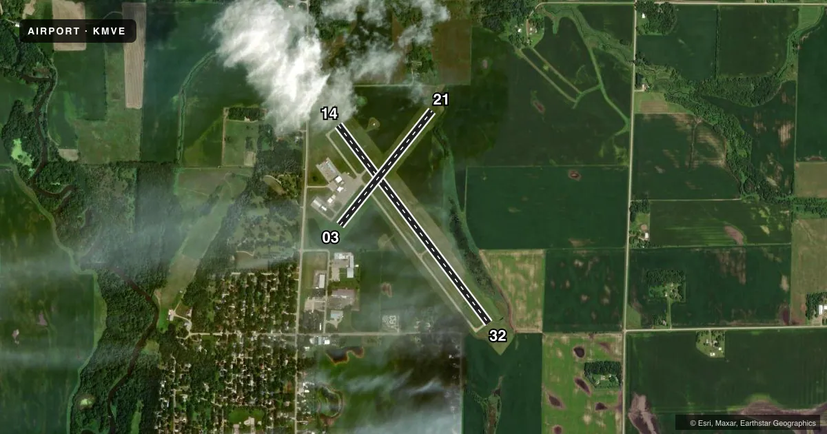
Runways & pattern
Full pagePattern entry · RWY 32
LEFT TRAFFIC| Runway | Heading (°M) | Length | Surface | Traffic |
|---|---|---|---|---|
| 14/32Favored | 141° / 321° | 3,999 ft | ASPH | Standard L |
| 03/21 | 36° / 216° | 2,361 ft | TURF | Standard L |
Runway end performance
| End | TORA | TODA | ASDA | LDA | VGSI | Approach lights | Obstruction |
|---|---|---|---|---|---|---|---|
| 14 | — | — | — | — | PAPI 4-box left(3°) | — | — |
| 32 | — | — | — | — | PAPI 4-box left(3°) | — | — |
| 21 | — | — | — | — | — | — | 7', brush, 133' from thr, 138' R of cntrln, slope 19 |
Declared distances in feet. TORA = takeoff run available, TODA = takeoff distance, ASDA = accelerate-stop, LDA = landing distance.
Airport sketch
Runways drawn to scale from FAA survey coordinates, rendered over satellite imagery. Not for navigation.
Approaches & charts
Services on the field
Fuel grades, oxygen, maintenance, ramp storage and lighting — as declared to the FAA by the airport operator.
Fuel & services
- Fuel
- 100LL
- Oxygen (bottled)
- Not available
- Oxygen (bulk)
- Not available
- Airframe repair
- Major
- Power plant repair
- Major
- Other services
- AGRI,SALES
Ramp & ground
- Transient storage
- Tie-down
- Hangar
- Landing fee
- No fee published
- Customs
- Not available
- Lighting schedule
- SEE RMK
- Beacon schedule
- SS-SR
- Beacon
- White / Green (civil land)(WG)
- Wind indicator
- Lighted
- Segmented circle
- No
Fuel & FBOs
Cheapest 100LL and Jet A on the field and nearby. Always confirm with the FBO before taxi.
Airport notes
Surface conditions, obstructions, local procedures, lighting outages and other notes published with each FAA cycle.
General notes
- RWY 03/21 NOT PLOWED WINTER MONTHS.
- ULTRALIGHTS ON AND INVOF ARPT.
- FOR CD IF UNA TO CTC ON FSS FREQ, CTC MINNEAPOLIS ARTCC AT 651-463-5588.
Lighting notes
- MIRL PRESET TO LOW SS-SR. TO INCR INTSY AND ACTVT REIL RY 14/32 & PAPI RY 14/32 - CTAF.
Fuel notes
- 100LLFUEL SELF SVC 24 HRS WITH CREDIT CARD.
Approach & departure obstructions
- 03RY 03/21 THRS & EDGES MARKED WITH YELLOW CONES.
Other notes
- PENDING.
- OWNERAND CHIPPEWA COUNTY.
VFR map & nearby airports
VFR sectional. Tap any ICAO chip to open that airport.
Key facts · KMVE
Answer card- ICAO
- KMVE
- Name
- MONTEVIDEO-CHIPPEWA COUNTY
- Location
- MONTEVIDEO, MINNESOTA
- Elevation
- 1,034 ft MSL
- Traffic pattern altitude
- 2,034 ft MSL (1,000 AGL)
- Control tower
- Non-towered (use CTAF)
- Total runways
- 2
- Longest runway
- 14/32 · 3,999 ft
- Published ILS approaches
- 0
- Published frequencies
- 2
- Magnetic variation
- 2°
- Current flight rules
- VFR
- Current wind
- 320° at 5 kt
- Favored runway now
- RWY 32
Montevideo-Chippewa County Airport (KMVE) sits in Montevideo, Minnesota. Field elevation is 1,034 ft MSL. The airport has two runways. The longest is 14/32 at 3,999 ft asphalt. Runway 03/21 is 2,361 ft turf.
There is no control tower. CTAF and UNICOM are both 122.8. No ILS approaches are published here, so plan with the current charted procedures in mind. Pattern altitude is not published in the facts, so use the standard 1,000 ft AGL for light piston traffic unless the current Chart Supplement says otherwise.
The on-field FBO is Montevideo-Chippewa County Airport. It carries 100LL. Fuel is self-serve 24 hours with credit card. The published remarks also note that runway 03/21 thresholds and edges are marked with yellow cones. Runway 03/21 is not plowed during winter months.
This is a non-towered field with ultralight activity on and near the airport. Expect normal see-and-avoid discipline on CTAF. Medium intensity runway lights are preset to low from sunset to sunrise. Use CTAF to increase intensity and to activate the runway end identifier lights on 14/32 plus the PAPI on 14/32. For clearance delivery, if Flight Service cannot be reached, Minneapolis ARTCC is listed as the backup contact. The airport is owned by Montevideo and Chippewa County.