METAR & TAF KDXX
Current METAR
Observed 19:35Z
KDXX 271935Z AUTO 36010KT 10SM CLR 31/22 A2980 RMK AO2 T03100219 $
- Wind
- 360° @ 10 kt
- Visibility
- 10 SM
- Temp / Dew
- 31°C / 22°C
- Altimeter
- 29.80 inHg
- Clouds
- CLR
- Density alt
- 3,411 ft
- Ceiling
- Unlimited
- Rules
- VFR
Airport info & contacts
Manager on record, flight service, ARTCC, attendance schedule and pattern altitude — published by the FAA and refreshed every 28 days.
Location
- From city
- 2 NM SE
- VFR sectional
- TWIN CITIES
- ARTCC
- ZMP · MINNEAPOLIS
- NOTAM facility
- DXX (NOTAM-D)
Airport manager
- Name
- MICHAEL DAHLE
- Phone
- 320-333-9300
- Address
- PO BOX 175, MADISON MN 56256-0175
Flight service · Hours
- FSS PNM
- PRINCETON1-800-WX-BRIEF
- Attendance
- Unattended
Frequencies
Tap any row to copy the frequency to your clipboard.
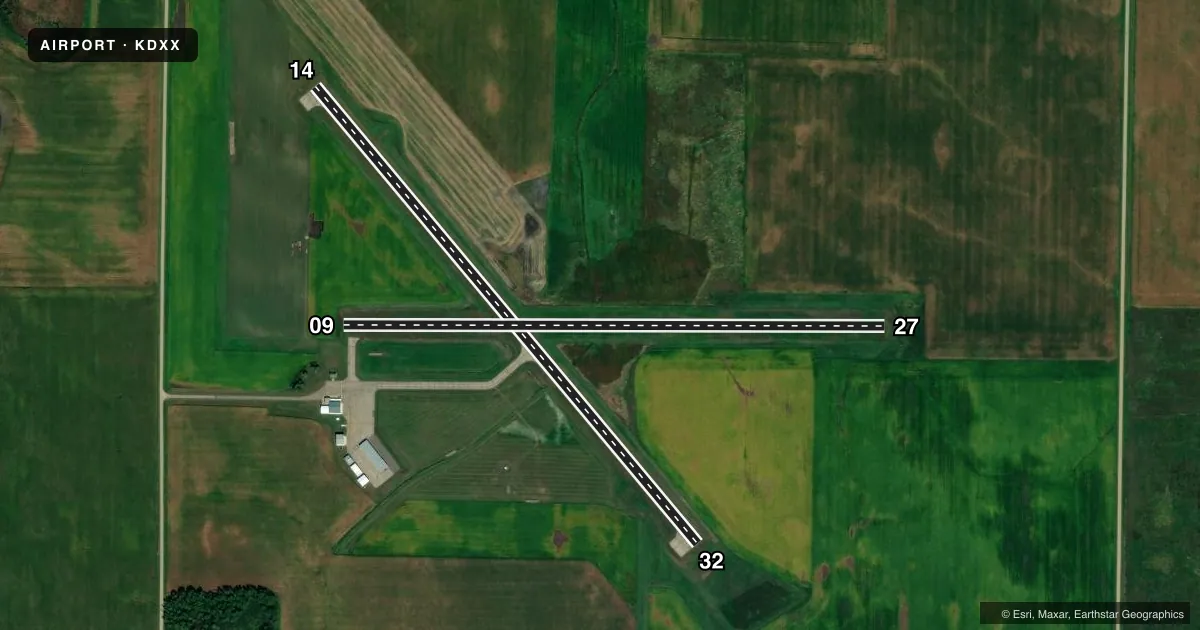
Runways & pattern
Full pagePattern entry · RWY 32
LEFT TRAFFIC| Runway | Heading (°M) | Length | Surface | Traffic |
|---|---|---|---|---|
| 14/32Favored | 137° / 317° | 3,300 ft | ASPH | Standard L |
| 09/27 | 87° / 267° | 3,003 ft | TURF | Standard L |
Runway end performance
| End | TORA | TODA | ASDA | LDA | VGSI | Approach lights | Obstruction |
|---|---|---|---|---|---|---|---|
| 14 | — | — | — | — | PAPI 4-box left(3°) | — | — |
| 32 | — | — | — | — | PAPI 4-box left(3°) | — | — |
Declared distances in feet. TORA = takeoff run available, TODA = takeoff distance, ASDA = accelerate-stop, LDA = landing distance.
Airport sketch
Runways drawn to scale from FAA survey coordinates, rendered over satellite imagery. Not for navigation.
Approaches & charts
Services on the field
Fuel grades, oxygen, maintenance, ramp storage and lighting — as declared to the FAA by the airport operator.
Fuel & services
- Fuel
- 100LL
- Oxygen (bottled)
- Not available
- Oxygen (bulk)
- Not available
- Airframe repair
- Not available
- Power plant repair
- Not available
Ramp & ground
- Transient storage
- Tie-down
- Hangar
- Landing fee
- No fee published
- Customs
- Not available
- Lighting schedule
- SEE RMK
- Beacon schedule
- SS-SR
- Beacon
- White / Green (civil land)(WG)
- Wind indicator
- Lighted
- Segmented circle
- No
Fuel & FBOs
Cheapest 100LL and Jet A on the field and nearby. Always confirm with the FBO before taxi.
Airport notes
Surface conditions, obstructions, local procedures, lighting outages and other notes published with each FAA cycle.
General notes
- FOR CD IF UNA TO CTC ON FSS FREQ, CTC MINNEAPOLIS ARTCC AT 651-463-5588.
Lighting notes
- ACTVT OR INCR INTST REIL RWY 14 & 32; PAPI RWY 14 & 32; MIRL RWY 14/32 - CTAF. MIRL RWY 14/32 PRESET LOW INTST SS-SR.
Fuel notes
- 100LLAVBL H24 VIA CREDIT CARD.
Runway surface & condition
- 09/27NOT PLOWED WINTER MONTHS.
Approach & departure obstructions
- 09YELLOW CONES.
- 27YELLOW CONES.
Other notes
- FOR HNGR CALL AMGR.
- OWNERALSO CITY OF MADISON AND LAC QUI PARLE COUNTY.
VFR map & nearby airports
VFR sectional. Tap any ICAO chip to open that airport.
Key facts · KDXX
Answer card- ICAO
- KDXX
- Name
- LAC QUI PARLE COUNTY
- Location
- MADISON, MINNESOTA
- Elevation
- 1,082.7 ft MSL
- Traffic pattern altitude
- 2,082.7 ft MSL (1,000 AGL)
- Control tower
- Non-towered (use CTAF)
- Total runways
- 2
- Longest runway
- 14/32 · 3,300 ft
- Published ILS approaches
- 0
- Published frequencies
- 2
- Magnetic variation
- 3°
- Current flight rules
- VFR
- Current wind
- 360° at 10 kt
- Favored runway now
- RWY 32
Lac Qui Parle County Airport is in Madison, Minnesota. The field elevation is 1,082.7 ft MSL. It has two runways. The longest is runway 14/32 at 3,300 ft asphalt. Runway 09/27 is 3,003 ft turf. There is no control tower. CTAF and UNICOM are both 122.8. No ILS approaches are published here.
Pattern altitude is not published. Use 1,000 ft AGL for light piston operations unless the current Chart Supplement says otherwise. That puts the standard pattern at about 2,083 ft MSL based on the field elevation. The airport is non-towered, so plan your calls early and keep a close ear on the CTAF.
The on-field FBO is Lac Qui Parle County Airport. It carries AVGAS 100LL. Fuel is available 24 hours by credit card. Runway 14/32 has medium intensity lighting. The lights are controlled by CTAF. PAPI is also published for 14 and 32. Runway end identifier lights are listed for those ends as well. Runway 09 and runway 27 ends are marked with yellow cones. Runways 09/27 are not plowed during winter months, so check surface conditions before you plan a turf arrival or departure. For clearance delivery, if you cannot reach flight service, Minneapolis ARTCC is the published backup contact.