METAR & TAF KVVV
Current METAR
Observed 17:15Z
KVVV 271715Z AUTO 33010KT 10SM CLR 28/21 A2983 RMK AO2
- Wind
- 330° @ 10 kt
- Visibility
- 10 SM
- Temp / Dew
- 28°C / 21°C
- Altimeter
- 29.83 inHg
- Clouds
- CLR
- Density alt
- 3,037 ft
- Ceiling
- Unlimited
- Rules
- VFR
Airport info & contacts
Manager on record, flight service, ARTCC, attendance schedule and pattern altitude — published by the FAA and refreshed every 28 days.
Location
- From city
- 1 NM SE
- VFR sectional
- TWIN CITIES
- ARTCC
- ZMP · MINNEAPOLIS
- NOTAM facility
- VVV (NOTAM-D)
Airport manager
- Name
- CHARLEEN GROSSMAN
- Phone
- 320-839-3428
- Address
- 315 MADISON AVE, ORTONVILLE MN 56278-1325
Flight service · Hours
- FSS PNM
- PRINCETON1-800-WX-BRIEF
- Attendance
- Unattended
Frequencies
Tap any row to copy the frequency to your clipboard.
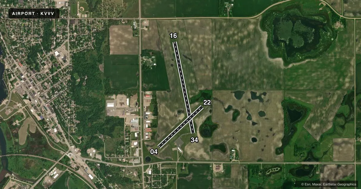
Runways & pattern
Full pagePattern entry · RWY 34
LEFT TRAFFIC| Runway | Heading (°M) | Length | Surface | Traffic |
|---|---|---|---|---|
| 16/34Favored | 164° / 344° | 3,417 ft | ASPH | Standard L |
| 04/22 | 42° / 222° | 2,175 ft | TURF | Standard L |
Runway end performance
| End | TORA | TODA | ASDA | LDA | VGSI | Approach lights | Obstruction |
|---|---|---|---|---|---|---|---|
| 16 | — | — | — | — | PAPI 4-box left(3°) | — | — |
| 34 | — | — | — | — | PAPI 4-box left(3°) | — | — |
Declared distances in feet. TORA = takeoff run available, TODA = takeoff distance, ASDA = accelerate-stop, LDA = landing distance.
Airport sketch
Runways drawn to scale from FAA survey coordinates, rendered over satellite imagery. Not for navigation.
Approaches & charts
Services on the field
Fuel grades, oxygen, maintenance, ramp storage and lighting — as declared to the FAA by the airport operator.
Fuel & services
- Fuel
- 100LLA
- Oxygen (bottled)
- Not available
- Oxygen (bulk)
- Not available
- Airframe repair
- Not available
- Power plant repair
- Not available
Ramp & ground
- Transient storage
- Tie-down
- Landing fee
- No fee published
- Customs
- Not available
- Lighting schedule
- SEE RMK
- Beacon schedule
- SS-SR
- Beacon
- White / Green (civil land)(WG)
- Wind indicator
- Lighted
- Segmented circle
- No
Fuel & FBOs
Cheapest 100LL and Jet A on the field and nearby. Always confirm with the FBO before taxi.
Airport notes
Surface conditions, obstructions, local procedures, lighting outages and other notes published with each FAA cycle.
General notes
- GCO AVBL ON FREQ 121.725 THRU MINNEAPOLIS ARTCC & FLT SVCS.
- WILDLIFE & WATERFOWL INVOF ARPT.
- ARPT UNMON MON-FRI 1700-0800 & WKENDS.
- FOR CD IF UNA VIA GCO CTC MINNEAPOLIS ARTCC AT 651-463-5588.
Lighting notes
- ACTVT OR INCR INTST PAPI RWY 16 & 34; MIRL RWY 16/34 - CTAF. MIRL RWY 16/34 PRESET LOW INTST.
Fuel notes
- 100LLFUEL AVBL H24 SELF SVC VIA CREDIT CARD.
Approach & departure obstructions
- 04YELLOW CONES.
- 22YELLOW CONES.
Other notes
- 16/34LOOSE AGGREGATE.
VFR map & nearby airports
VFR sectional. Tap any ICAO chip to open that airport.
Key facts · KVVV
Answer card- ICAO
- KVVV
- Name
- ORTONVILLE MUNI/MARTINSON FLD
- Location
- ORTONVILLE, MINNESOTA
- Elevation
- 1,101.2 ft MSL
- Traffic pattern altitude
- 2,101.2 ft MSL (1,000 AGL)
- Control tower
- Non-towered (use CTAF)
- Total runways
- 2
- Longest runway
- 16/34 · 3,417 ft
- Published ILS approaches
- 0
- Published frequencies
- 2
- Magnetic variation
- 5°
- Current flight rules
- VFR
- Current wind
- 330° at 10 kt
- Favored runway now
- RWY 34
Ortonville Muni/Martinson Fld (KVVV) sits in Ortonville, Minnesota. Field elevation is 1,101.2 ft MSL. The airport has two runways. The longest is 16/34 at 3,417 ft asphalt. Runway 04/22 is 2,175 ft turf. There is no control tower. CTAF and UNICOM are both 122.8. No ILS approaches are published here.
Pattern altitude is not published. Use the standard 1,000 ft AGL pattern unless the current FAA Chart Supplement or local procedures say otherwise. For a light piston, that puts the pattern at about 2,101.2 ft MSL based on the published field elevation.
Ortonville Municipal Airport is the on-field FBO. It carries 100LL. Fuel is available 24 hours a day self service by credit card. The published remarks also call out loose aggregate on runway 16/34. Runway 04 and runway 22 are marked with yellow cones. The field is unmonitored Monday through Friday from 1700 to 0800. It is also unmonitored on weekends. Wildlife and waterfowl are in the area, so keep a sharp scan on approach and departure.
This is a non-towered airport with simple radio work. The lack of a published ILS means you should plan for VFR or whatever non-ILS procedure is current. Check the runway surface condition before using 16/34, especially if you want the asphalt strip.