METAR & TAF 06Y
06Y does not publish a METAR.
Showing the nearest reporting station: KETH (WHEATON MUNI) · 16.3 NM away. Conditions at 06Y may differ.
METAR · KETH
Observed 22:53Z
KETH 272253Z AUTO 34006KT 10SM CLR 31/22 A2981 RMK AO2
- Wind
- 340° @ 6 kt
- Visibility
- 10 SM
- Temp / Dew
- 31°C / 22°C
- Altimeter
- 29.81 inHg
- Clouds
- CLR
- Density alt
- 3,381 ft
- Ceiling
- Unlimited
- Rules
- VFR
Airport info & contacts
Manager on record, flight service, ARTCC, attendance schedule and pattern altitude — published by the FAA and refreshed every 28 days.
Location
- From city
- 2 NM NW
- VFR sectional
- TWIN CITIES
- ARTCC
- ZMP · MINNEAPOLIS
- NOTAM facility
- PNM (NOTAM-D)
Airport manager
- Name
- NEIL BLUME
- Phone
- 320-760-1959
- Address
- PO BOX 241, HERMAN MN 56248-0241
Flight service · Hours
- FSS PNM
- PRINCETON1-800-WX-BRIEF
- Attendance
- Unattended
Frequencies
Tap any row to copy the frequency to your clipboard.
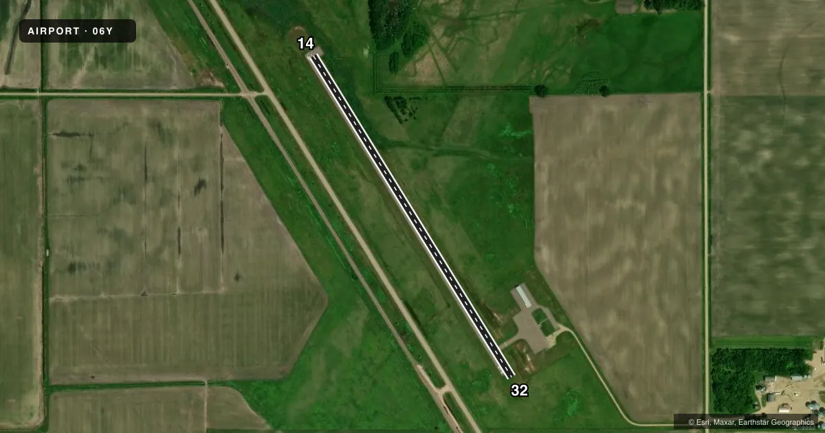
Runways & pattern
Full pagePattern entry · RWY 32
LEFT TRAFFICAirport sketch
Runways drawn to scale from FAA survey coordinates, rendered over satellite imagery. Not for navigation.
Approaches & charts
Services on the field
Fuel grades, oxygen, maintenance, ramp storage and lighting — as declared to the FAA by the airport operator.
Fuel & services
- Fuel
- 100LL
- Oxygen (bottled)
- Not available
- Oxygen (bulk)
- Not available
- Airframe repair
- Not available
- Power plant repair
- Not available
Ramp & ground
- Transient storage
- Tie-down
- Hangar
- Landing fee
- No fee published
- Lighting schedule
- SS-SR
- Beacon schedule
- SS-SR
- Beacon
- White / Green (civil land)(WG)
- Wind indicator
- Lighted
- Segmented circle
- No
Fuel & FBOs
Cheapest 100LL and Jet A on the field and nearby. Always confirm with the FBO before taxi.
Airport notes
Surface conditions, obstructions, local procedures, lighting outages and other notes published with each FAA cycle.
General notes
- ULTRALIGHTS ON & INVOF ARPT.
- FOR CD CTC MINNEAPOLIS ARTCC AT 651-463-5588.
Fuel notes
- 100LLFOR FUEL CALL 320-905-2982 OR AMGR.
Runway surface & condition
- 14/32NSTD LIRL DUE TO SPACING.
VFR map & nearby airports
VFR sectional. Tap any ICAO chip to open that airport.
Key facts · 06Y
Answer card- ICAO
- 06Y
- Name
- HERMAN MUNI
- Location
- HERMAN, MINNESOTA
- Elevation
- 1,068 ft MSL
- Traffic pattern altitude
- 2,068 ft MSL (1,000 AGL)
- Control tower
- Non-towered (use CTAF)
- Total runways
- 1
- Longest runway
- 14/32 · 2,997 ft
- Published ILS approaches
- 0
- Published frequencies
- 1
- Magnetic variation
- 5°
- Current flight rules
- VFR
- Current wind
- 340° at 6 kt
- Favored runway now
- RWY 32
Herman Muni is in Herman, Minnesota. The field elevation is 1,068 ft MSL. It has one runway. Runway 14/32 is 2,997 ft long with an asphalt surface. The airport is non-towered, so self-announce on CTAF 122.9 and keep a close scan for local traffic.
No ILS approaches are published here. The pattern altitude is not published, so use the standard 1,000 ft AGL for light piston operations unless the current Chart Supplement says otherwise. That puts the pattern at 2,068 ft MSL based on the listed field elevation. Ultralights are reported on and near the airport, so expect mixed traffic and stay sharp in the pattern.
Published remarks say runway lighting on 14/32 is nonstandard low intensity because of spacing. That is worth checking before a night arrival. For fuel, call the airport manager or use the listed number before you go. For clearance delivery, contact Minneapolis ARTCC at 651-463-5588. If you are planning a first stop here, verify any local procedures with the current FAA Chart Supplement before departure.