METAR & TAF KETH
Current METAR
Observed 22:53Z
KETH 272253Z AUTO 34006KT 10SM CLR 31/22 A2981 RMK AO2
- Wind
- 340° @ 6 kt
- Visibility
- 10 SM
- Temp / Dew
- 31°C / 22°C
- Altimeter
- 29.81 inHg
- Clouds
- CLR
- Density alt
- 3,325 ft
- Ceiling
- Unlimited
- Rules
- VFR
Airport info & contacts
Manager on record, flight service, ARTCC, attendance schedule and pattern altitude — published by the FAA and refreshed every 28 days.
Location
- From city
- 3 NM SW
- VFR sectional
- TWIN CITIES
- Pattern altitude
- 976 ft AGL · 1,999 ft MSL
- ARTCC
- ZMP · MINNEAPOLIS
- NOTAM facility
- ETH (NOTAM-D)
Airport manager
- Name
- AMY OLSON
- Phone
- 320-563-4110
- Address
- PO BOX 868, 104 9TH ST N, WHEATON MN 56296
Flight service · Hours
- FSS PNM
- PRINCETON1-800-WX-BRIEF
- Attendance
- Unattended
Frequencies
Tap any row to copy the frequency to your clipboard.
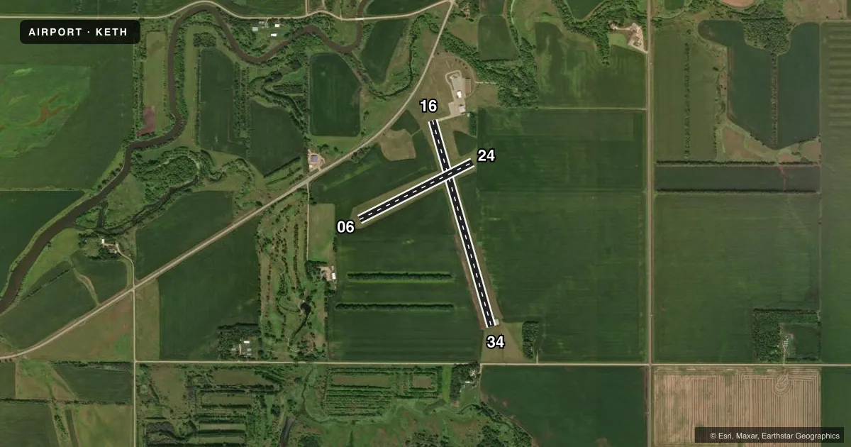
Runways & pattern
Full pagePattern entry · RWY 34
LEFT TRAFFIC| Runway | Heading (°M) | Length | Surface | Traffic |
|---|---|---|---|---|
| 16/34Favored | 159° / 339° | 3,298 ft | ASPH | Standard L |
| 06/24 | 58° / 238° | 1,953 ft | TURF | Standard L |
Runway end performance
| End | TORA | TODA | ASDA | LDA | VGSI | Approach lights | Obstruction |
|---|---|---|---|---|---|---|---|
| 16 | — | — | — | — | PAPI 2-box left(3°) | — | — |
| 34 | — | — | — | — | PAPI 2-box left(3°) | — | — |
Declared distances in feet. TORA = takeoff run available, TODA = takeoff distance, ASDA = accelerate-stop, LDA = landing distance.
Airport sketch
Runways drawn to scale from FAA survey coordinates, rendered over satellite imagery. Not for navigation.
Approaches & charts
Services on the field
Fuel grades, oxygen, maintenance, ramp storage and lighting — as declared to the FAA by the airport operator.
Fuel & services
- Fuel
- Not available
- Oxygen (bottled)
- Not available
- Oxygen (bulk)
- Not available
- Airframe repair
- Not available
- Power plant repair
- Not available
- Other services
- AGRI,SALES
Ramp & ground
- Transient storage
- Tie-down
- Landing fee
- No fee published
- Customs
- Not available
- Lighting schedule
- SEE RMK
- Beacon schedule
- SS-SR
- Beacon
- White / Green (civil land)(WG)
- Wind indicator
- Lighted
- Segmented circle
- No
Fuel & FBOs
Cheapest 100LL and Jet A on the field and nearby. Always confirm with the FBO before taxi.
Airport notes
Surface conditions, obstructions, local procedures, lighting outages and other notes published with each FAA cycle.
General notes
- FOR CD CTC MINNEAPOLIS ARTCC AT 651-463-5588.
Lighting notes
- RY 16/34 MIRL PRESET TO LOW INTST. TO INCR INTST & ACTVT PAPI RY 16/34 - CTAF.
Runway surface & condition
- 06/24NOT PLOWED WINTER MONTHS.
Approach & departure obstructions
- 06MARKED WITH YELLOW CONES.
- 34PAPI 34 UNUSABLE BYD 8 DEGREE LEFT OF COURSE.
VFR map & nearby airports
VFR sectional. Tap any ICAO chip to open that airport.
Key facts · KETH
Answer card- ICAO
- KETH
- Name
- WHEATON MUNI
- Location
- WHEATON, MINNESOTA
- Elevation
- 1,022.7 ft MSL
- Traffic pattern altitude
- 1,998.7 ft MSL (976 AGL)
- Control tower
- Non-towered (use CTAF)
- Total runways
- 2
- Longest runway
- 16/34 · 3,298 ft
- Published ILS approaches
- 0
- Published frequencies
- 2
- Magnetic variation
- 5°
- Current flight rules
- VFR
- Current wind
- 340° at 6 kt
- Favored runway now
- RWY 34
Wheaton Muni is in Wheaton, Minnesota. The field elevation is 1,022.7 ft MSL. It has two runways. The longest is runway 16/34 at 3,298 ft. There is no control tower. CTAF and UNICOM are both 122.8.
Pattern altitude is 976 ft AGL. That is 1,998.7 ft MSL. No ILS approaches are published here, so plan with the current chart and weather briefing in mind. The paved runway is 16/34. Runway 06/24 is turf and is 1,953 ft long. Published remarks say runway 16/34 lighting is preset to low intensity. Use CTAF to increase intensity and to activate the PAPI for runway 16/34.
This is a small non-towered field, so standard self-announce traffic discipline matters. The published remarks also note that runway 06/24 is not plowed during winter months. Runway 06 is marked with yellow cones. The PAPI for runway 34 is unusable beyond 8 degrees left of course. There are no on-field FBOs listed, so contact the airport operator directly or call the field on CTAF for current services before you go. For clearance delivery, contact Minneapolis ARTCC at 651-463-5588.