METAR & TAF 8D3
Current METAR
Observed 20:56Z
K8D3 272056Z AUTO 33007KT 31/21 A2981 RMK AO1 SLP072 T03110211 56003
- Wind
- 330° @ 7 kt
- Visibility
- —
- Temp / Dew
- 31°C / 21°C
- Altimeter
- 29.81 inHg
- Clouds
- Clear
- Density alt
- 3,498 ft
- Ceiling
- Unlimited
- Rules
- VFR
Airport info & contacts
Manager on record, flight service, ARTCC, attendance schedule and pattern altitude — published by the FAA and refreshed every 28 days.
Location
- From city
- 3 NM E
- VFR sectional
- TWIN CITIES
- ARTCC
- ZMP · MINNEAPOLIS
- NOTAM facility
- HON (NOTAM-D)
Airport manager
- Name
- CITY OF SISSETON
- Phone
- 605-880-1796
- Address
- 406 2ND AVE, SISSETON SD 57262
Flight service · Hours
- FSS HON
- HURON1-800-WX-BRIEF
- Attendance
- Unattended
Frequencies
Tap any row to copy the frequency to your clipboard.
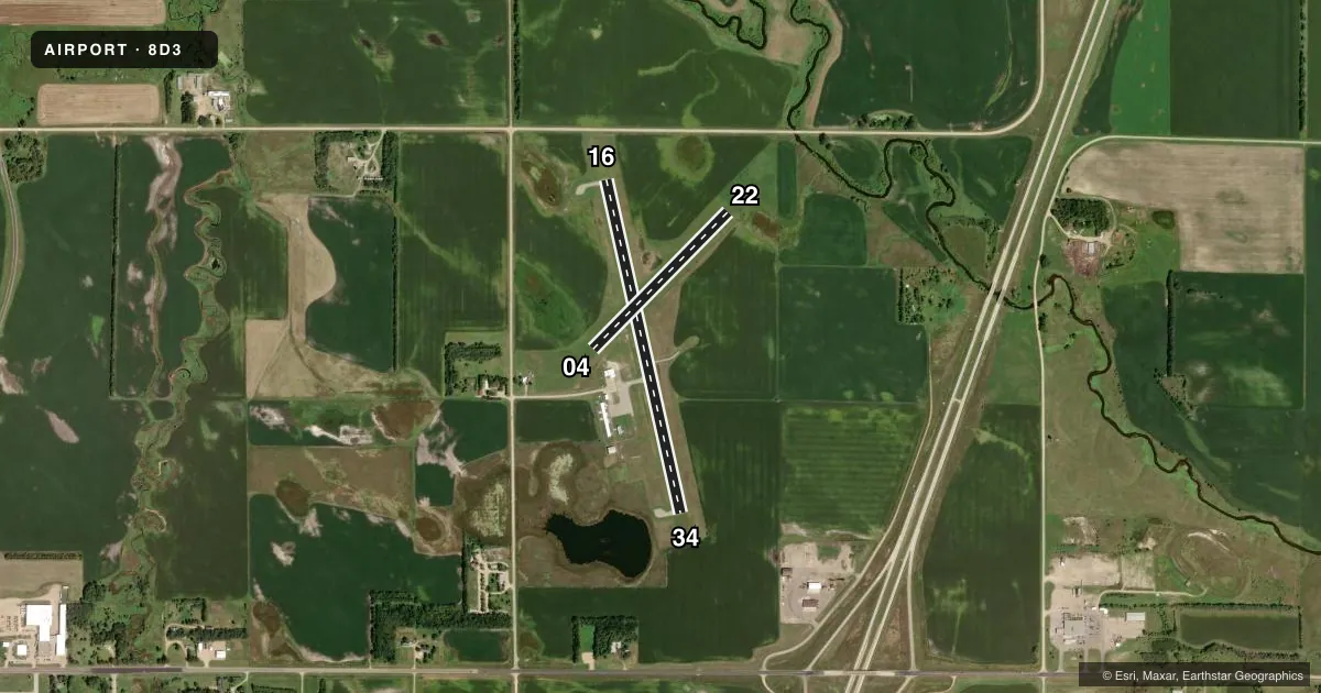
Runways & pattern
Full pagePattern entry · RWY 34
LEFT TRAFFIC| Runway | Heading (°M) | Length | Surface | Traffic |
|---|---|---|---|---|
| 16/34Favored | 164° / 344° | 3,400 ft | ASPH | Standard L |
| 04/22 | 42° / 222° | 1,914 ft | TURF | Standard L |
Runway end performance
| End | TORA | TODA | ASDA | LDA | VGSI | Approach lights | Obstruction |
|---|---|---|---|---|---|---|---|
| 16 | — | — | — | — | PAPI 2-box left(3°) | — | 12', road, 500' from thr, 0' R of cntrln, slope 25 |
| 34 | — | — | — | — | PAPI 2-box left(3°) | — | 4', fence, 285' from thr, 0' R of cntrln, slope 21 |
| 04 | — | — | — | — | — | — | 42', pole, 1080' from thr, 75' R of cntrln, slope 25 |
| 22 | — | — | — | — | — | — | 55', tree, 1277' from thr, 175' R of cntrln, slope 23 |
Declared distances in feet. TORA = takeoff run available, TODA = takeoff distance, ASDA = accelerate-stop, LDA = landing distance.
Airport sketch
Runways drawn to scale from FAA survey coordinates, rendered over satellite imagery. Not for navigation.
Approaches & charts
Services on the field
Fuel grades, oxygen, maintenance, ramp storage and lighting — as declared to the FAA by the airport operator.
Fuel & services
- Fuel
- 100LL
- Oxygen (bottled)
- Not available
- Oxygen (bulk)
- Not available
- Airframe repair
- Not available
- Power plant repair
- Not available
- Other services
- AGRI
Ramp & ground
- Transient storage
- Tie-down
- Landing fee
- No fee published
- Customs
- Not available
- Lighting schedule
- SEE RMK
- Beacon schedule
- SS-SR
- Beacon
- White / Green (civil land)(WG)
- Wind indicator
- Lighted
- Segmented circle
- No
Fuel & FBOs
Cheapest 100LL and Jet A on the field and nearby. Always confirm with the FBO before taxi.
Airport notes
Surface conditions, obstructions, local procedures, lighting outages and other notes published with each FAA cycle.
General notes
- RY 04 +4' FENCE 300' FM THR & 175' FM THR & 125' FM CNTRLN.
- RY 16 +4' FENCE 460' FM THR.
- RY 22 +4' FENCE 300' FM THR & 85' L FM CNTRLN & 240' FM THR 125' L FM CNTRLN.
- RY 34 +4' FENCE 285' FM THR.
- WATERFOWL AND GULLS AROUND AND INVOF ARPT.
- FOR CD CTC MINNEAPOLIS ARTCC AT 651-463-5588.
Lighting notes
- ACTVT PAPI RWY 16 & 34; MIRL RWY 16/34 - CTAF.
Fuel notes
- 100LLFUEL AVBL 24 HRS WITH CREDIT CARD.
Runway surface & condition
- 04/22RY 04/22 CLSD WINTER MONTHS.
Approach & departure obstructions
- 04RY 04/22 MARKED WITH BLACK AND WHITE CONES.
VFR map & nearby airports
VFR sectional. Tap any ICAO chip to open that airport.
Key facts · 8D3
Answer card- ICAO
- 8D3
- Name
- SISSETON MUNI
- Location
- SISSETON, SOUTH DAKOTA
- Elevation
- 1,162.2 ft MSL
- Traffic pattern altitude
- 2,162.2 ft MSL (1,000 AGL)
- Control tower
- Non-towered (use CTAF)
- Total runways
- 2
- Longest runway
- 16/34 · 3,400 ft
- Published ILS approaches
- 0
- Published frequencies
- 1
- Magnetic variation
- 3°
- Current flight rules
- VFR
- Current wind
- 330° at 7 kt
- Favored runway now
- RWY 34
Sisseton Muni sits in Sisseton, South Dakota. Field elevation is 1,162.2 ft MSL. The airport has two runways. The longest is runway 16/34 at 3,400 ft asphalt. Runway 04/22 is 1,914 ft turf. There is no control tower. CTAF is 122.9. No ILS approaches are published.
Pattern altitude is not published. Use the standard 1,000 ft AGL for light piston traffic unless the current Chart Supplement says otherwise. That puts the pattern at 2,162.2 ft MSL by the standard rule of thumb. Verify the local pattern before you go. The on-field FBO is Sisseton Municipal Airport. It carries 100LL. Fuel is available 24 hours with credit card.
A few published remarks matter here. Runway 16/34 has PAPI and medium intensity lights that are activated on CTAF. Runway 04/22 is marked with black and white cones. That turf runway is closed during winter months. There are also fence hazards near both ends of the runways, so pay close attention on short final and during the flare. Waterfowl and gulls are reported in the area. For clearance delivery, contact Minneapolis ARTCC. If you are planning a night or low-visibility arrival, remember there is no published ILS. Check the current Chart Supplement and brief the field carefully before departure.