METAR & TAF KBTN
Current METAR
Observed 15:15Z
KBTN 271515Z AUTO VRB06KT 7SM CLR 25/21 A2984 RMK AO2
- Wind
- VAR @ 6 kt
- Visibility
- 7 SM
- Temp / Dew
- 25°C / 21°C
- Altimeter
- 29.84 inHg
- Clouds
- CLR
- Density alt
- 2,934 ft
- Ceiling
- Unlimited
- Rules
- VFR
Airport info & contacts
Manager on record, flight service, ARTCC, attendance schedule and pattern altitude — published by the FAA and refreshed every 28 days.
Location
- From city
- 2 NM N
- VFR sectional
- TWIN CITIES
- ARTCC
- ZMP · MINNEAPOLIS
- NOTAM facility
- HON (NOTAM-D)
Airport manager
- Name
- RYAN FURMAN
- Phone
- (605) 470-0485
- Address
- PO BOX 87, BRITTON SD 57430
Flight service · Hours
- FSS HON
- HURON1-800-WX-BRIEF
- Attendance
- MON-FRI · DALGT
Frequencies
Tap any row to copy the frequency to your clipboard.
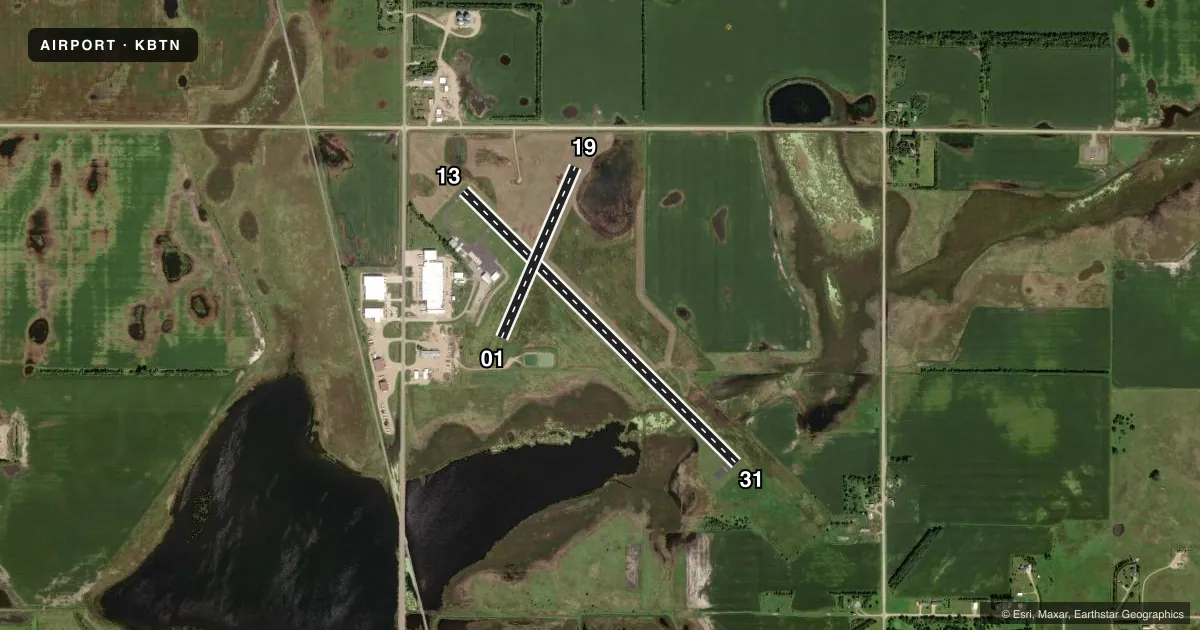
Runways & pattern
Full pagePattern entry · RWY 01
LEFT TRAFFIC| Runway | Heading (°M) | Length | Surface | Traffic |
|---|---|---|---|---|
| 13/31 | 131° / 311° | 4,210 ft | ASPH | Standard L |
| 01/19Favored | 19° / 199° | 2,034 ft | TURF | Standard L |
Runway end performance
| End | TORA | TODA | ASDA | LDA | VGSI | Approach lights | Obstruction |
|---|---|---|---|---|---|---|---|
| 13 | — | — | — | — | PAPI 2-box left(3°) | — | 15', road, 800' from thr, 0' R of cntrln, slope 40 |
| 31 | — | — | — | — | PAPI 2-box left(3.2°) | — | 88', trees, 1990' from thr, 0' R of cntrln, slope 20 |
| 01 | — | — | — | — | — | — | 6', fence, 125' from thr, 0' R of cntrln, slope 20 |
| 19 | — | — | — | — | — | — | 18', road, 390' from thr, 0' R of cntrln, slope 21 |
Declared distances in feet. TORA = takeoff run available, TODA = takeoff distance, ASDA = accelerate-stop, LDA = landing distance.
Airport sketch
Runways drawn to scale from FAA survey coordinates, rendered over satellite imagery. Not for navigation.
Approaches & charts
Services on the field
Fuel grades, oxygen, maintenance, ramp storage and lighting — as declared to the FAA by the airport operator.
Fuel & services
- Fuel
- 100LLA
- Oxygen (bottled)
- Not available
- Oxygen (bulk)
- Not available
- Airframe repair
- Not available
- Power plant repair
- Not available
- Other services
- AGRI
Ramp & ground
- Transient storage
- Tie-down
- Hangar
- Landing fee
- No fee published
- Customs
- Not available
- Lighting schedule
- SEE RMK
- Beacon schedule
- SS-SR
- Beacon
- White / Green (civil land)(WG)
- Wind indicator
- Lighted
- Segmented circle
- No
Fuel & FBOs
Cheapest 100LL and Jet A on the field and nearby. Always confirm with the FBO before taxi.
Airport notes
Surface conditions, obstructions, local procedures, lighting outages and other notes published with each FAA cycle.
General notes
- RY 19 +6 FT FENCE 190 FT FM THLD.
- WATERFOWL AND GULLS ON & INVOF ARPT.
- GCO AVBL ON FREQ 121.725 (4 CLICKS TO MINNEAPOLIS CENTER AND 6 CLICKS TO FLT SVCS)
- WILDLIFE ON AND AROUND AIRPORT
- FOR CD IF UNA VIA GCO CTC MINNEAPOLIS ARTCC AT 651-463-5588.
Lighting notes
- ACTVT MIRL, REIL & PAPI RYS 13 & 31 - CTAF.
Fuel notes
- 100LLFUEL AVBL 24 HRS WITH CREDIT CARD
Approach & departure obstructions
- 01NSTD MKGS: RY 01/19 MARKED WITH BLACK AND WHITE CONES.
- 01HAS +6' FENCE POST 98' FM CNTRLN OF RY.
Other notes
- AUTOMATED UNICOM.
VFR map & nearby airports
VFR sectional. Tap any ICAO chip to open that airport.
Key facts · KBTN
Answer card- ICAO
- KBTN
- Name
- BRITTON MUNI
- Location
- BRITTON, SOUTH DAKOTA
- Elevation
- 1,318.4 ft MSL
- Traffic pattern altitude
- 2,318.4 ft MSL (1,000 AGL)
- Control tower
- Non-towered (use CTAF)
- Total runways
- 2
- Longest runway
- 13/31 · 4,210 ft
- Published ILS approaches
- 0
- Published frequencies
- 2
- Magnetic variation
- 4°
- Current flight rules
- VFR
- Current wind
- 000° at 6 kt
- Favored runway now
- RWY 01
Britton Muni sits in Britton, South Dakota. Field elevation is 1,318.4 ft MSL. The airport has two runways. The longest is runway 13/31 at 4,210 ft asphalt. Runway 01/19 is 2,034 ft turf. There is no control tower. CTAF and UNICOM are both 122.8. No ILS approaches are published here.
Pattern altitude is not published. Use the standard 1,000 ft AGL pattern for light piston traffic unless the current Chart Supplement or local procedures say otherwise. The field has medium intensity runway lights, runway end identifier lights and PAPI on runways 13 and 31. That helps for night work on the paved strip. Dakota Ag Service is on the field. It carries 100LL and Jet A. 100LL is available 24 hours with a credit card. Wildlife is a real factor here. Waterfowl and gulls are reported on and near the airport. There is also a fence post over 6 ft tall near runway 01. There is a fence near the threshold of runway 19. Runway 01/19 also has nonstandard black and white cone markings. If you need clearance delivery and ground comms are not available, contact Minneapolis ARTCC. For a first-time arrival, brief the turf runway, the wildlife and the lighting setup before you go.