METAR & TAF 1D7
1D7 does not publish a METAR.
Showing the nearest reporting station: KATY (WATERTOWN RGNL) · 27.4 NM away. Conditions at 1D7 may differ.
METAR · KATY
Observed 16:53Z
KATY 271653Z AUTO 36012KT 10SM CLR 31/13 A2986 RMK AO2 SLP094 T03110128
- Wind
- 360° @ 12 kt
- Visibility
- 10 SM
- Temp / Dew
- 31°C / 13°C
- Altimeter
- 29.86 inHg
- Clouds
- CLR
- Density alt
- 4,298 ft
- Ceiling
- Unlimited
- Rules
- VFR
Airport info & contacts
Manager on record, flight service, ARTCC, attendance schedule and pattern altitude — published by the FAA and refreshed every 28 days.
Location
- From city
- 2 NM S
- VFR sectional
- TWIN CITIES
- ARTCC
- ZMP · MINNEAPOLIS
- NOTAM facility
- HON (NOTAM-D)
Airport manager
- Name
- CITY OF WEBSTER
- Phone
- 605-345-3241
- Address
- PO BOX 539, WEBSTER SD 57274
Flight service · Hours
- FSS HON
- HURON1-800-WX-BRIEF
- Attendance
- Unattended
Frequencies
Tap any row to copy the frequency to your clipboard.
Runways & pattern
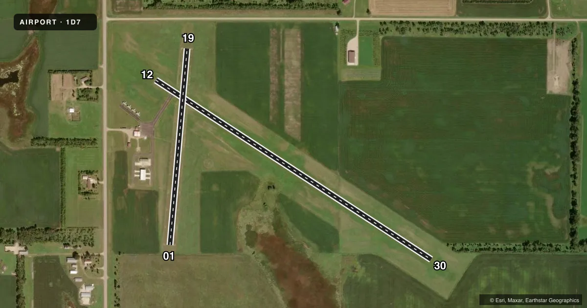
Full pagePattern entry · RWY 01
LEFT TRAFFIC| Runway | Heading (°M) | Length | Surface | Traffic |
|---|---|---|---|---|
| 12/30 | 116° / 296° | 3,705 ft | ASPH | Standard L |
| 01/19Favored | 358° / 178° | 2,221 ft | TURF | Standard L |
Runway end performance
| End | TORA | TODA | ASDA | LDA | VGSI | Approach lights | Obstruction |
|---|---|---|---|---|---|---|---|
| 12 | — | — | — | — | PAPI 2-box left(3°) | — | 19', road, 600' from thr, 0' R of cntrln, slope 21 |
| 30 | — | — | — | — | PAPI 2-box left(3°) | — | — |
| 01 | — | — | — | — | — | — | 5', fence, 100' from thr, 0' R of cntrln, slope 20 |
Declared distances in feet. TORA = takeoff run available, TODA = takeoff distance, ASDA = accelerate-stop, LDA = landing distance.
Airport sketch
Runways drawn to scale from FAA survey coordinates, rendered over satellite imagery. Not for navigation.
Approaches & charts
Services on the field
Fuel grades, oxygen, maintenance, ramp storage and lighting — as declared to the FAA by the airport operator.
Fuel & services
- Fuel
- 100LL
- Oxygen (bottled)
- Not available
- Oxygen (bulk)
- Not available
- Airframe repair
- Not available
- Power plant repair
- Not available
- Other services
- AGRI,INSTR
Ramp & ground
- Transient storage
- Tie-down
- Customs
- Not available
- Lighting schedule
- SEE RMK
- Beacon schedule
- SS-SR
- Beacon
- White / Green (civil land)(WG)
- Wind indicator
- Lighted
- Segmented circle
- Yes
Fuel & FBOs
Cheapest 100LL and Jet A on the field and nearby. Always confirm with the FBO before taxi.
Airport notes
Surface conditions, obstructions, local procedures, lighting outages and other notes published with each FAA cycle.
General notes
- RY 19 +4' FENCE 306' FM THR; 17 ROAD 340' FM THR.
- BIRDS AND WATERFOWL ON AND INVOF ARPT.
- FOR CD CTC MINNEAPOLIS ARTCC AT 651-463-5588.
Lighting notes
- ACTVT MIRL RWY 12/30; PAPI RWY 12 & 30 - CTAF.
Fuel notes
- 100LLFUEL AVBL 24 HRS WITH CREDIT CARD.
Runway surface & condition
- 01/19CLSD WINTER MONTHS.
Approach & departure obstructions
- 01RWY 01/19 MKD WITH WHITE BLACK TIPPED MKR CONES.
Other notes
- EXISTED PRIOR TO 1959.
- AUTOMATED UNICOM. ADZY ALSO AVBL BY CALLING 617-262-3825.
- OWNERAFTER HOURS PHONE (605) 345-4040
VFR map & nearby airports
VFR sectional. Tap any ICAO chip to open that airport.
Key facts · 1D7
Answer card- ICAO
- 1D7
- Name
- THE SIGURD ANDERSON
- Location
- WEBSTER, SOUTH DAKOTA
- Elevation
- 1,857.6 ft MSL
- Traffic pattern altitude
- 2,857.6 ft MSL (1,000 AGL)
- Control tower
- Non-towered (use CTAF)
- Total runways
- 2
- Longest runway
- 12/30 · 3,705 ft
- Published ILS approaches
- 0
- Published frequencies
- 1
- Magnetic variation
- 7°
- Current flight rules
- VFR
- Current wind
- 360° at 12 kt
- Favored runway now
- RWY 01
The Sigurd Anderson Airport sits near Webster, South Dakota. Field elevation is 1,857.6 ft MSL. It has two runways. The longest is runway 12/30 at 3,705 ft. Runway 01/19 is turf at 2,221 ft. There is no control tower. CTAF is 122.9. No ILS approaches are published, so plan to use current charts and weather carefully if you are arriving in lower ceilings or reduced visibility. Pattern altitude is not published. Use 1,000 ft AGL for light piston traffic unless the current Chart Supplement says otherwise.
Runway 12/30 has medium intensity lighting. PAPI is available on both 12 and 30. It is activated by CTAF. 100LL is available 24 hours with credit card. No on-field FBOs are listed, so verify services with the airport operator or call the field directly before arrival. The airport also has automated UNICOM, plus advisory service by phone. Birds and waterfowl are reported on and near the airport. Runway 19 has a fence and a road close to the threshold, so keep that in mind on short final. Runway 01/19 is closed during winter months. For clearance delivery, contact Minneapolis ARTCC. This field is a good one to brief before you go, especially if you are planning a night arrival or a winter trip.