METAR & TAF KATY
Current METAR
Observed 19:53Z
KATY 271953Z AUTO 30008KT 10SM CLR 32/16 A2985 RMK AO2 SLP093 T03220156
- Wind
- 300° @ 8 kt
- Visibility
- 10 SM
- Temp / Dew
- 32°C / 16°C
- Altimeter
- 29.85 inHg
- Clouds
- CLR
- Density alt
- 4,296 ft
- Ceiling
- Unlimited
- Rules
- VFR
Airport info & contacts
Manager on record, flight service, ARTCC, attendance schedule and pattern altitude — published by the FAA and refreshed every 28 days.
Location
- From city
- 2 NM NW
- VFR sectional
- TWIN CITIES
- ARTCC
- ZMP · MINNEAPOLIS
- NOTAM facility
- ATY (NOTAM-D)
Airport manager
- Name
- IAN MERIWETHER-CHALFANT
- Phone
- 605-753-9357
- Address
- 550 E AIRPORT DRIVE, WATERTOWN SD 57201
Flight service · Hours
- FSS HON
- HURON1-800-WX-BRIEF
- Attendance
- 0430-2030
Frequencies
Tap any row to copy the frequency to your clipboard.
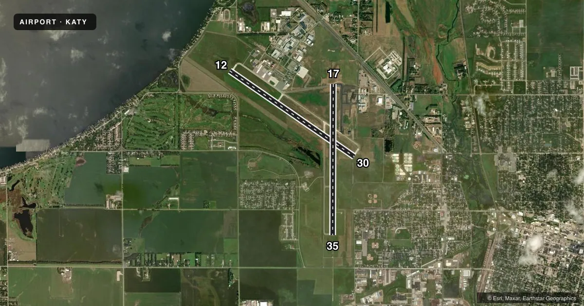
Runways & pattern
Full pagePattern entry · RWY 30
LEFT TRAFFIC| Runway | Heading (°M) | Length | Surface | Traffic |
|---|---|---|---|---|
| 12/30Favored | 119° / 299° | 6,898 ft | CONC | Standard L |
| 17/35 | 174° / 354° | 6,893 ft | CONC | Standard L |
Runway end performance
| End | TORA | TODA | ASDA | LDA | VGSI | Approach lights | Obstruction |
|---|---|---|---|---|---|---|---|
| 12 | 6,899' | 6,899' | 6,899' | 6,899' | PAPI 4-box left(3°) | — | — |
| 30 | 6,899' | 6,899' | 6,899' | 6,899' | PAPI 4-box left(3°) | — | 51', tree, 2013' from thr, 329' R of cntrln, slope 35 |
| 17 | 6,894' | 6,894' | 6,894' | 6,894' | PAPI 4-box left(3°) | — | — |
| 35 | 6,894' | 6,894' | 6,894' | 6,894' | PAPI 4-box left(3°) | MALSR | 83', bldg, 3775' from thr, 412' R of cntrln, slope 43 |
Declared distances in feet. TORA = takeoff run available, TODA = takeoff distance, ASDA = accelerate-stop, LDA = landing distance.
Airport sketch
Runways drawn to scale from FAA survey coordinates, rendered over satellite imagery. Not for navigation.
Approaches & charts
ILS · 1
Services on the field
Fuel grades, oxygen, maintenance, ramp storage and lighting — as declared to the FAA by the airport operator.
Fuel & services
- Fuel
- 100LLA
- Airframe repair
- Major
- Power plant repair
- Major
- Other services
- AFRT,AGRI,AMB,CARGO,CHTR,INSTR,RNTL,SALES
Ramp & ground
- Transient storage
- Tie-down
- Hangar
- Landing fee
- Yes
- Customs
- Not available
- Lighting schedule
- SEE RMK
- Beacon schedule
- SS-SR
- Beacon
- White / Green (civil land)(WG)
- Wind indicator
- Lighted
- Segmented circle
- Yes
Fuel & FBOs
Cheapest 100LL and Jet A on the field and nearby. Always confirm with the FBO before taxi.
Airport notes
Surface conditions, obstructions, local procedures, lighting outages and other notes published with each FAA cycle.
General notes
- GULLS & GEESE ON & INVOF ARPT APR-NOV.
- GLIDER OPNS APR THRU SEP.
- ANNUALLY APRIL- SEPT HAY CUTTING OPNS IN PROGRESS; FARMING EQUIP MAY BE IN APCHS.
- ARPT SFC COND NOT MONITORED 2230-0430.
- FOR CD IF UNA TO CTC ON FSS FREQ, CTC MINNEAPOLIS ARTCC AT 651-463-5588.
- GLDR OPNS PROHIBITED ON TWY D.
Lighting notes
- ACTVT MALSR RWY 35; PAPI RWY 12, 17, 30, & 35; HIRL RWY 17/35; MIRL RWY 12/30; REIL RWY 12, 17, & 30 - CTAF.
Runway surface & condition
- 12/30PCR VALUE: 509/R/D/W/T
- 17/35PCR VALUE: 491/R/D/W/T
Other notes
- PPR 48 HRS UNSKED ACR OPNS WITH MORE THAN 30 PSGR SEATS CALL AMGR 605 882-6209.
- MANAGER605-753-9357
VFR map & nearby airports
VFR sectional. Tap any ICAO chip to open that airport.
Key facts · KATY
Answer card- ICAO
- KATY
- Name
- WATERTOWN RGNL
- Location
- WATERTOWN, SOUTH DAKOTA
- Elevation
- 1,749.3 ft MSL
- Traffic pattern altitude
- 2,749.3 ft MSL (1,000 AGL)
- Control tower
- Non-towered (use CTAF)
- Total runways
- 2
- Longest runway
- 12/30 · 6,898 ft
- Published ILS approaches
- 1
- Published frequencies
- 2
- Magnetic variation
- 6°
- Current flight rules
- VFR
- Current wind
- 300° at 8 kt
- Favored runway now
- RWY 30
Watertown Rgnl is in Watertown, South Dakota. The field elevation is 1,749.3 ft MSL. It has two concrete runways. The longest is 6,898 ft on 12/30. There is no control tower. CTAF and UNICOM are both 123.05.
One ILS approach is published for runway 35. Pattern altitude is not published in the facts, so use the standard 1,000 ft AGL for light piston traffic unless the current FAA Chart Supplement says otherwise. ATY Aviation is on the field. It carries 100LL and Jet A Prist. Call ahead at (605) 753-1230 for current service details.
The published remarks matter here. Surface condition is not monitored from 2230 to 0430. Gulls and geese are common from April through November. Glider ops run from April through September. Hay cutting also happens from April through September, so expect farm equipment in the approaches. Runway 35 has MALSR lighting. PAPI is available on 12, 17, 30 and 35. If you are planning a larger or unscheduled air carrier operation, check the airport manager first. The airport manager can be reached at 605-753-9357. For a first-time arrival, review the current Chart Supplement for any updated procedures before you go.