METAR & TAF 6E5
Current METAR
Observed 10:15Z
K6E5 271015Z AUTO 36004KT 1 1/4SM BR FEW040 SCT046 SCT070 23/23 A2982 RMK AO2
- Wind
- 360° @ 4 kt
- Visibility
- 0.25 SM
- Temp / Dew
- 23°C / 23°C
- Altimeter
- 29.82 inHg
- Clouds
- SCT
- Density alt
- 3,230 ft
- Ceiling
- Unlimited
- Rules
- LIFR
Airport info & contacts
Manager on record, flight service, ARTCC, attendance schedule and pattern altitude — published by the FAA and refreshed every 28 days.
Location
- From city
- 2 NM N
- VFR sectional
- OMAHA
- ARTCC
- ZMP · MINNEAPOLIS
- NOTAM facility
- HON (NOTAM-D)
Airport manager
- Name
- CASEY HARTY
- Phone
- 605-860-0248
- Address
- PO BOX 70, DESMET SD 57231
Flight service · Hours
- FSS HON
- HURON1-800-WX-BRIEF
- Attendance
- Unattended
Frequencies
Tap any row to copy the frequency to your clipboard.
Runways & pattern
Full pagePattern entry · RWY 34
LEFT TRAFFICRunway end performance
| End | TORA | TODA | ASDA | LDA | VGSI | Approach lights | Obstruction |
|---|---|---|---|---|---|---|---|
| 16 | — | — | — | — | PAPI 2-box left(3°) | — | — |
| 34 | — | — | — | — | PAPI 2-box left(3°) | — | — |
Declared distances in feet. TORA = takeoff run available, TODA = takeoff distance, ASDA = accelerate-stop, LDA = landing distance.
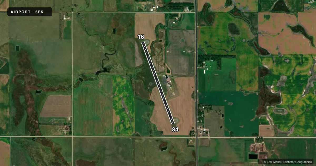
Airport sketch
Runways drawn to scale from FAA survey coordinates, rendered over satellite imagery. Not for navigation.
Approaches & charts
Services on the field
Fuel grades, oxygen, maintenance, ramp storage and lighting — as declared to the FAA by the airport operator.
Fuel & services
- Fuel
- Not available
- Oxygen (bottled)
- Not available
- Oxygen (bulk)
- Not available
- Airframe repair
- Not available
- Power plant repair
- Not available
- Other services
- AGRI,INSTR
Ramp & ground
- Transient storage
- Tie-down
- Hangar
- Landing fee
- No fee published
- Customs
- Not available
- Lighting schedule
- SEE RMK
- Beacon schedule
- SS-SR
- Beacon
- White / Green (civil land)(WG)
- Wind indicator
- Lighted
- Segmented circle
- Yes
Fuel & FBOs
Cheapest 100LL and Jet A on the field and nearby. Always confirm with the FBO before taxi.
Airport notes
Surface conditions, obstructions, local procedures, lighting outages and other notes published with each FAA cycle.
General notes
- FOR CD CTC MINNEAPOLIS ARTCC AT 651-463-5588.
Lighting notes
- ACTVT PAPI RWY 16 & 34; MIRL RWY 16/34 - CTAF.
VFR map & nearby airports
VFR sectional. Tap any ICAO chip to open that airport.
Key facts · 6E5
Answer card- ICAO
- 6E5
- Name
- WILDER
- Location
- DESMET, SOUTH DAKOTA
- Elevation
- 1,730.4 ft MSL
- Traffic pattern altitude
- 2,730.4 ft MSL (1,000 AGL)
- Control tower
- Non-towered (use CTAF)
- Total runways
- 1
- Longest runway
- 16/34 · 3,700 ft
- Published ILS approaches
- 0
- Published frequencies
- 1
- Magnetic variation
- 3°
- Current flight rules
- LIFR
- Current wind
- 360° at 4 kt
- Favored runway now
- RWY 34
Wilder (6E5) sits near De Smet, South Dakota. Field elevation is 1,730.4 ft MSL. The airport has one runway. Runway 16/34 is 3,700 ft of asphalt, with magnetic headings 160° and 340°. There is no control tower. CTAF is 122.9.
No ILS approaches are published here. The pattern altitude is not published in the facts, so use the standard 1,000 ft AGL for light piston operations unless the current FAA Chart Supplement says otherwise. The published remarks matter here. Runway 16 and runway 34 have medium intensity lights that are controlled on CTAF. The PAPI is active on both ends. For IFR clearance delivery, Minneapolis ARTCC can be reached at 651-463-5588.
There are no on-field FBOs listed in the facts. Plan on confirming fuel and services with the airport operator or the FBO directly before you go. At this elevation, expect some performance loss on warm days. The field is straightforward, but you still want to verify runway lighting and any current remarks before a night arrival or an IFR departure.