METAR & TAF KBKX
Current METAR
Observed 11:56Z
KBKX 121156Z AUTO 31007KT 10SM -RA FEW120 12/09 A2999 RMK AO2 RAB05 SLP160 P0000 60000 70015 T01220094 10161 20122 51025
- Wind
- 310° @ 7 kt
- Visibility
- 10 SM
- Temp / Dew
- 12°C / 9°C
- Altimeter
- 29.99 inHg
- Clouds
- FEW
- Density alt
- 1,596 ft
- Ceiling
- Unlimited
- Rules
- VFR
Airport info & contacts
Manager on record, flight service, ARTCC, attendance schedule and pattern altitude — published by the FAA and refreshed every 28 days.
Location
- From city
- 0 NM SW
- VFR sectional
- OMAHA
- ARTCC
- ZMP · MINNEAPOLIS
- NOTAM facility
- BKX (NOTAM-D)
Airport manager
- Name
- LUCAS DAHL
- Phone
- 605-697-8664
- Address
- 509 W SECOND STREET, BROOKINGS SD 57006
Flight service · Hours
- FSS HON
- HURON1-800-WX-BRIEF
- Attendance
- 0800-1800
Frequencies
Tap any row to copy the frequency to your clipboard.
Runways & pattern
Full pagePattern entry · RWY 30
LEFT TRAFFIC| Runway | Heading (°M) | Length | Surface | Traffic |
|---|---|---|---|---|
| 12/30Favored | 116° / 296° | 6,000 ft | ASPH | Standard L |
| 17/35 | 174° / 354° | 3,600 ft | ASPH | Standard L |
Runway end performance
| End | TORA | TODA | ASDA | LDA | VGSI | Approach lights | Obstruction |
|---|---|---|---|---|---|---|---|
| 12 | 6,000' | 6,000' | 6,000' | 6,000' | PAPI 4-box left(3°) | MALSR | — |
| 30 | 6,000' | 6,000' | 6,000' | 6,000' | PAPI 4-box left(3°) | — | — |
| 17 | 3,600' | 3,600' | 3,600' | 3,600' | PAPI 2-box left(3°) | — | — |
| 35 | 3,600' | 3,600' | 3,600' | 3,600' | PAPI 2-box left(3°) | — | — |
Declared distances in feet. TORA = takeoff run available, TODA = takeoff distance, ASDA = accelerate-stop, LDA = landing distance.
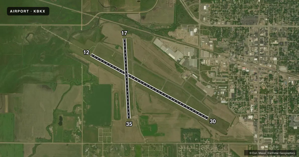
Airport sketch
Runways drawn to scale from FAA survey coordinates, rendered over satellite imagery. Not for navigation.
Approaches & charts
ILS · 1
Services on the field
Fuel grades, oxygen, maintenance, ramp storage and lighting — as declared to the FAA by the airport operator.
Fuel & services
- Fuel
- 100LLA
- Oxygen (bottled)
- Not available
- Oxygen (bulk)
- Not available
- Airframe repair
- Major
- Power plant repair
- Major
- Other services
- AGRI,CHTR,INSTR,RNTL
Ramp & ground
- Transient storage
- Tie-down
- Hangar
- Landing fee
- No fee published
- Customs
- Not available
- Lighting schedule
- SEE RMK
- Beacon schedule
- SS-SR
- Beacon
- White / Green (civil land)(WG)
- Wind indicator
- Lighted
- Segmented circle
- No
Fuel & FBOs
Cheapest 100LL and Jet A on the field and nearby. Always confirm with the FBO before taxi.
Airport notes
Surface conditions, obstructions, local procedures, lighting outages and other notes published with each FAA cycle.
General notes
- INTENSIVE STUDENT TRAINING.
- LARGE FLOCKS OF GEESE & GULLS ON & INVOF ARPT APR THRU OCT.
- FOR ATTENDANT AFT HRS CALL 605-692-2779 OR 605-690-6013.
- GCO AVBL ON FREQ 121.725 (4 CLICKS TO MINNEAPOLIS CENTER, 6 CLICKS TO FLT SVC)
- FOR CD IF UNA TO CTC ON FSS FREQ, CTC MINNEAPOLIS ARTCC AT 651-463-5588.
- AIRFIELD CONDS NOT MNTD BTN 1900 - 0700 HRS LCL TIME.
- RWY 30 IS PREFERRED RWY WHEN WNDS ARE CALM.
Lighting notes
- ACTVT MALSR RWY 12; REIL RWY 17, 30, 35; PAPI RWY 12, 17, 30, 35; HIRL RWY 12/30; MIRL RWY 17/35 - CTAF
VFR map & nearby airports
VFR sectional. Tap any ICAO chip to open that airport.
Key facts · KBKX
Answer card- ICAO
- KBKX
- Name
- BROOKINGS RGNL
- Location
- BROOKINGS, SOUTH DAKOTA
- Elevation
- 1,647.5 ft MSL
- Traffic pattern altitude
- 2,647.5 ft MSL (1,000 AGL)
- Control tower
- Non-towered (use CTAF)
- Total runways
- 2
- Longest runway
- 12/30 · 6,000 ft
- Published ILS approaches
- 1
- Published frequencies
- 2
- Magnetic variation
- 3°
- Current flight rules
- VFR
- Current wind
- 310° at 7 kt
- Favored runway now
- RWY 30
Brookings Rgnl is in Brookings, South Dakota. The field elevation is 1,647.5 ft MSL. It has two asphalt runways. The longest is 6,000 ft on runway 12/30. There is no control tower. CTAF and UNICOM are both 123.0.
Runway 12 has the ILS. The published lighting is useful to know before you go. MALSR is on runway 12. REIL is available on 17, 30 and 35. PAPI is available on all runway ends. HIRL serves 12/30. MIRL serves 17/35 on CTAF. Pattern altitude is not published. Use 1,000 ft AGL for light piston traffic unless the current Chart Supplement says otherwise.
Pheasant's Fury Aviation is on the field. It carries 100LL and Jet A Prist. If you need an attendant after hours, the published numbers are 605-692-2779 and 605-690-6013. The airport sees intensive student training. Runway 30 is the preferred runway when winds are calm. Airfield conditions are not maintained between 1900 and 0700 local. Large flocks of geese and gulls can be on and near the apron through October. That makes a good lookout important on taxi, takeoff and final.