METAR & TAF 4P3
4P3 does not publish a METAR.
Showing the nearest reporting station: KPQN (PIPESTONE MUNI) · 12.7 NM away. Conditions at 4P3 may differ.
METAR · KPQN
Observed 12:35Z
KPQN 271235Z AUTO 02006KT 6SM BR CLR 26/26 A2983 RMK AO2 T02590259
- Wind
- 020° @ 6 kt
- Visibility
- 6 SM
- Temp / Dew
- 26°C / 26°C
- Altimeter
- 29.83 inHg
- Clouds
- CLR
- Density alt
- 3,472 ft
- Ceiling
- Unlimited
- Rules
- VFR
Airport info & contacts
Manager on record, flight service, ARTCC, attendance schedule and pattern altitude — published by the FAA and refreshed every 28 days.
Location
- From city
- 3 NM S
- VFR sectional
- OMAHA
- ARTCC
- ZMP · MINNEAPOLIS
- NOTAM facility
- HON (NOTAM-D)
Airport manager
- Name
- COHL TURNQUIST
- Phone
- 605-997-2492
- Address
- 1005 W ELM AVE., FLANDREAU SD 57028
Flight service · Hours
- FSS HON
- HURON1-800-WX-BRIEF
- Attendance
- Unattended
Frequencies
Tap any row to copy the frequency to your clipboard.
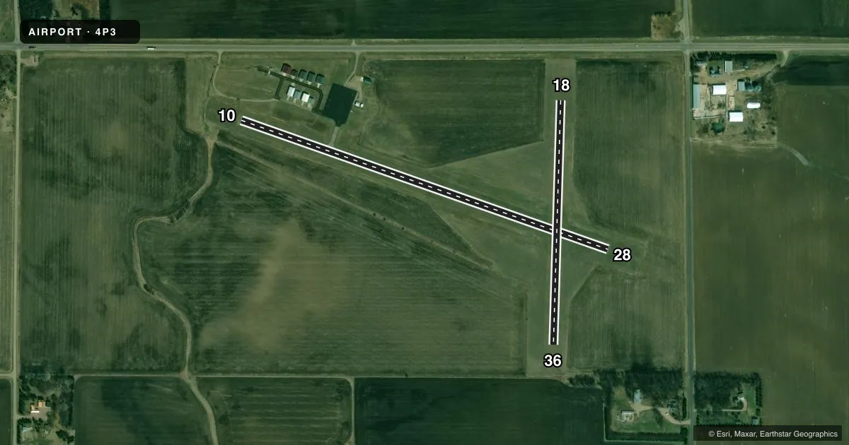
Runways & pattern
Full pagePattern entry · RWY 36
LEFT TRAFFIC| Runway | Heading (°M) | Length | Surface | Traffic |
|---|---|---|---|---|
| 10/28 | 103° / 283° | 3,099 ft | ASPH | Standard L |
| 18/36Favored | 176° / 356° | 1,948 ft | TURF | Standard L |
Runway end performance
| End | TORA | TODA | ASDA | LDA | VGSI | Approach lights | Obstruction |
|---|---|---|---|---|---|---|---|
| 10 | — | — | — | — | — | — | 60', trees, 1530' from thr, 125' R of cntrln, slope 22 |
| 28 | — | — | — | — | — | — | 20', road, 630' from thr, 0' R of cntrln, slope 21 |
Declared distances in feet. TORA = takeoff run available, TODA = takeoff distance, ASDA = accelerate-stop, LDA = landing distance.
Airport sketch
Runways drawn to scale from FAA survey coordinates, rendered over satellite imagery. Not for navigation.
Approaches & charts
Services on the field
Fuel grades, oxygen, maintenance, ramp storage and lighting — as declared to the FAA by the airport operator.
Fuel & services
- Fuel
- 100LL
- Oxygen (bottled)
- Not available
- Oxygen (bulk)
- Not available
- Airframe repair
- Not available
- Power plant repair
- Not available
Ramp & ground
- Transient storage
- Tie-down
- Hangar
- Landing fee
- No fee published
- Lighting schedule
- SEE RMK
- Beacon schedule
- SS-SR
- Beacon
- White / Green (civil land)(WG)
- Wind indicator
- Lighted
- Segmented circle
- Yes
Fuel & FBOs
Cheapest 100LL and Jet A on the field and nearby. Always confirm with the FBO before taxi.
Airport notes
Surface conditions, obstructions, local procedures, lighting outages and other notes published with each FAA cycle.
General notes
- WILDLIFE ON & INVOF ARPT.
- FOR CD CTC SIOUX FALLS APCH AT 605-336-8602; WHEN APCH CLSD CTC MINNEAPOLIS ARTCC AT 651-463-5588.
Lighting notes
- ACTVT LIRL RWY 10/28 - CTAF.
Other notes
- PRVDD 8/26 IS ABNDD PRIOR TO 10/28 ACTVTN. THRS LCTD TO PRVD MIN 20:1 CLRNC OVER OBSTNS. ALL OBSTN-FREE PRIM SFCS 125 FT EA SIDE OF RWY PRVDD.
VFR map & nearby airports
VFR sectional. Tap any ICAO chip to open that airport.
Key facts · 4P3
Answer card- ICAO
- 4P3
- Name
- FLANDREAU MUNI
- Location
- FLANDREAU, SOUTH DAKOTA
- Elevation
- 1,645.2 ft MSL
- Traffic pattern altitude
- 2,645.2 ft MSL (1,000 AGL)
- Control tower
- Non-towered (use CTAF)
- Total runways
- 2
- Longest runway
- 10/28 · 3,099 ft
- Published ILS approaches
- 0
- Published frequencies
- 1
- Magnetic variation
- 6°
- Current flight rules
- VFR
- Current wind
- 020° at 6 kt
- Favored runway now
- RWY 36
Flandreau Muni sits in Flandreau, South Dakota. Field elevation is 1,645.2 ft MSL. The airport has two runways. The longest is runway 10/28 at 3,099 ft. Runway 18/36 is turf and measures 1,948 ft. There is no control tower. CTAF is 122.9.
No ILS approaches are published here. Pattern altitude is not published, so use the standard 1,000 ft AGL for light piston operations unless the current Chart Supplement says otherwise. The published remarks matter here. Runway 10/28 lighting is activated on CTAF. The field also notes wildlife on and near the airport. The remarks say runway 8/26 is abandoned before 10/28 lighting is used. Threshold placement was set to give obstruction clearance. The primary surfaces are kept clear 125 ft each side of the runway.
This is a non-towered field, so plan your calls early and keep a close eye out in the pattern. For clearance delivery, contact Sioux Falls Approach at 605-336-8602. When approach is closed, contact Minneapolis ARTCC at 651-463-5588. No on-field FBOs are listed, so verify current fuel and service options with the airport operator or the field directly before you go.