METAR & TAF Y14
Y14 does not publish a METAR.
Showing the nearest reporting station: KFSD (JOE FOSS FLD) · 8.1 NM away. Conditions at Y14 may differ.
METAR · KFSD
Observed 19:56Z
KFSD 271956Z 35006KT 10SM CLR 35/16 A2983 RMK AO2 SLP087 T03500161 $
- Wind
- 350° @ 6 kt
- Visibility
- 10 SM
- Temp / Dew
- 35°C / 16°C
- Altimeter
- 29.83 inHg
- Clouds
- CLR
- Density alt
- 4,386 ft
- Ceiling
- Unlimited
- Rules
- VFR
Airport info & contacts
Manager on record, flight service, ARTCC, attendance schedule and pattern altitude — published by the FAA and refreshed every 28 days.
Location
- From city
- 2 NM NE
- VFR sectional
- OMAHA
- ARTCC
- ZMP · MINNEAPOLIS
- NOTAM facility
- HON (NOTAM-D)
Airport manager
- Name
- DAVID MYERS
- Phone
- 605-836-0503
- Address
- 104 N MAIN, SUITE 110, CANTON SD 57013
Flight service · Hours
- FSS HON
- HURON1-800-WX-BRIEF
- Attendance
- 0800-DUSK
Frequencies
Tap any row to copy the frequency to your clipboard.
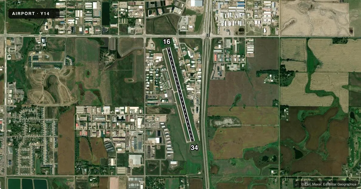
Runways & pattern
Full pagePattern entry · RWY 34
LEFT TRAFFICRunway end performance
| End | TORA | TODA | ASDA | LDA | VGSI | Approach lights | Obstruction |
|---|---|---|---|---|---|---|---|
| 16 | — | — | — | — | PAPI 2-box left(3°) | — | 10', road, 470' from thr, 0' R of cntrln, slope 27 |
| 34 | — | — | — | — | PAPI 2-box left(3°) | — | — |
Declared distances in feet. TORA = takeoff run available, TODA = takeoff distance, ASDA = accelerate-stop, LDA = landing distance.
Airport sketch
Runways drawn to scale from FAA survey coordinates, rendered over satellite imagery. Not for navigation.
Approaches & charts
Services on the field
Fuel grades, oxygen, maintenance, ramp storage and lighting — as declared to the FAA by the airport operator.
Fuel & services
- Fuel
- 100LLA
- Oxygen (bottled)
- Not available
- Oxygen (bulk)
- Not available
- Airframe repair
- Major
- Power plant repair
- Major
- Other services
- AVNCS,CHTR,INSTR,RNTL
Ramp & ground
- Transient storage
- Tie-down
- Hangar
- Landing fee
- No fee published
- Lighting schedule
- SEE RMK
- Beacon schedule
- SS-SR
- Beacon
- White / Green (civil land)(WG)
- Wind indicator
- Lighted
- Segmented circle
- No
Fuel & FBOs
Cheapest 100LL and Jet A on the field and nearby. Always confirm with the FBO before taxi.
Airport notes
Surface conditions, obstructions, local procedures, lighting outages and other notes published with each FAA cycle.
General notes
- ULTRALIGHTS ON & INVOF ARPT.
- BE ALERT: ACFT ON APCH TO RY 03 AT JOE FOSS FIELD (FSD) DESCENDING/HOLDING AT 3300 FT OVER ROKKY LOM LCTD 2.4 MILES NNW OF THE ARPT.
- HAY CUTTING OPERATIONS MAY-SEP; FARMING EQUIPMENT MAY BE IN APCH ZONES.
- GCO AVBL ON FREQ 121.725 ( 4 CLICKS TO SIOUX FALLS TWR )
- FOR CD CTC SIOUX FALLS APCH AT 605-336-8602; WHEN APCH CLSD CTC MINNEAPOLIS ARTCC AT 651-463-5588.
- DUE TO THE PROXIMITY OF FSD ARPT SUG VFR ACFT DEPARTING Y14 MNTN AT OR BLW 2500 FT MSL UNTIL 5 NM FM Y14 OR CTC FSD APCH ON 125.8 FOR TFC ADZYS.
Lighting notes
- ACTVT MIRL RWY 16/34 - CTAF.
Fuel notes
- 100LLAVBL H24 VIA CREDIT CARD.
- AAVBL H24 VIA CREDIT CARD.
Other notes
- AUTOMATED UNICOM.
VFR map & nearby airports
VFR sectional. Tap any ICAO chip to open that airport.
Key facts · Y14
Answer card- ICAO
- Y14
- Name
- MARV SKIE-LINCOLN COUNTY
- Location
- TEA, SOUTH DAKOTA
- Elevation
- 1,511.4 ft MSL
- Traffic pattern altitude
- 2,511.4 ft MSL (1,000 AGL)
- Control tower
- Non-towered (use CTAF)
- Total runways
- 1
- Longest runway
- 16/34 · 3,650 ft
- Published ILS approaches
- 0
- Published frequencies
- 2
- Magnetic variation
- 6°
- Current flight rules
- VFR
- Current wind
- 350° at 6 kt
- Favored runway now
- RWY 34
MARV SKIE-LINCOLN COUNTY (Y14) sits in Tea, South Dakota. Field elevation is 1,511.4 ft MSL. The airport has one runway. Runway 16/34 is 3,650 ft long with a concrete surface. There is no control tower. CTAF and UNICOM are both 122.8. No ILS approaches are published here.
Pattern altitude is not published. Use the standard 1,000 ft AGL pattern unless local traffic or current guidance says otherwise. Legacy Aviation is on the field. It carries 100LL and Jet A. 100LL is available 24 hours via credit card. The airport also has automated UNICOM. Medium intensity runway lights on 16/34 are activated by the CTAF.
This is a busy local-use field near Sioux Falls traffic. The Chart Supplement notes VFR departures should stay at or below 2,500 ft MSL until 5 NM from Y14. Then call Sioux Falls Approach for traffic advisories. Watch for aircraft on approach to Joe Foss Field. The notes also mention hay cutting from May through September. Farming equipment may be in the approach zones. Ultralights also operate on and near the airport. Check the current Chart Supplement and call the airport operator or Legacy Aviation if you need current local procedures before you go.