METAR & TAF KRRQ
KRRQ does not publish a METAR.
Showing the nearest reporting station: KLYV (QUENTIN AANENSON FLD) · 10.0 NM away. Conditions at KRRQ may differ.
METAR · KLYV
Observed 16:35Z
KLYV 271635Z AUTO 02008KT 10SM CLR 30/16 A2984 RMK AO2
- Wind
- 020° @ 8 kt
- Visibility
- 10 SM
- Temp / Dew
- 30°C / 16°C
- Altimeter
- 29.84 inHg
- Clouds
- CLR
- Density alt
- 3,589 ft
- Ceiling
- Unlimited
- Rules
- VFR
Airport info & contacts
Manager on record, flight service, ARTCC, attendance schedule and pattern altitude — published by the FAA and refreshed every 28 days.
Location
- From city
- 2 NM NW
- VFR sectional
- OMAHA
- ARTCC
- ZMP · MINNEAPOLIS
- NOTAM facility
- FOD (NOTAM-D)
Airport manager
- Name
- MICAH FREESE
- Phone
- 712-472-4585
- Address
- 411 FIRST AVENUE, ROCK RAPIDS IA 51246
Flight service · Hours
- FSS FOD
- FORT DODGE1-800-WX-BRIEF
- Attendance
- MON-FRI · 0900-1700
- SAT · 0900-1200
Frequencies
Tap any row to copy the frequency to your clipboard.
Runways & pattern
Full pagePattern entry · RWY 34
LEFT TRAFFICRunway end performance
| End | TORA | TODA | ASDA | LDA | VGSI | Approach lights | Obstruction |
|---|---|---|---|---|---|---|---|
| 16 | — | — | — | — | PAPI 2-box left(3°) | — | 51', tree, 1107' from thr, 284' R of cntrln, slope 17 |
| 34 | — | — | — | — | PAPI 2-box left(3°) | — | — |
Declared distances in feet. TORA = takeoff run available, TODA = takeoff distance, ASDA = accelerate-stop, LDA = landing distance.
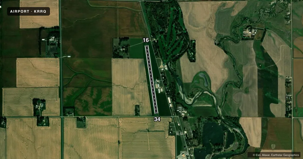
Airport sketch
Runways drawn to scale from FAA survey coordinates, rendered over satellite imagery. Not for navigation.
Approaches & charts
Services on the field
Fuel grades, oxygen, maintenance, ramp storage and lighting — as declared to the FAA by the airport operator.
Fuel & services
- Fuel
- 100LL
- Oxygen (bottled)
- Not available
- Oxygen (bulk)
- Not available
- Airframe repair
- Major
- Power plant repair
- Major
Ramp & ground
- Transient storage
- Tie-down
- Hangar
- Landing fee
- No fee published
- Customs
- Not available
- Lighting schedule
- SEE RMK
- Beacon schedule
- SS-SR
- Beacon
- White / Green (civil land)(WG)
- Wind indicator
- Lighted
- Segmented circle
- No
Fuel & FBOs
Cheapest 100LL and Jet A on the field and nearby. Always confirm with the FBO before taxi.
Airport notes
Surface conditions, obstructions, local procedures, lighting outages and other notes published with each FAA cycle.
General notes
- RWY 34 IS CALM WIND RWY.
- CAUTION: MIGRATORY WATERFOWL ADJ MOVEMENT AREAS.
- FOR CD CTC SIOUX FALLS APCH AT 605-336-8602, WHEN APCH CLSD CTC MINNEAPOLIS ARTCC AT 651-463-5588.
Lighting notes
- ACTVT REIL RWYS 16 & 34; MIRL RWY 16/34; PAPI RWYS 16 & 34 - CTAF.
Approach & departure obstructions
- 16RY 16 +15 FT ROAD 155 FT DSTC ON CNTRLN.
- 34+16 FT ROAD 1 30 FT DSTC L/R.
- 16CLNC 16:1 FROM DSPLCD THLD TO TREE.
- 34APCH SLOPE 26:1 TO DSPLCD THLD FM 16 FT ROAD 430 FT FM DSPLCD THLD L/R.
Other notes
- THIS AIRPORT HAS BEEN SURVEYED BY THE NATIONAL GEODETIC SURVEY.
- 1FOR AFTER HRS CALL (605) 988-4314.
VFR map & nearby airports
VFR sectional. Tap any ICAO chip to open that airport.
Key facts · KRRQ
Answer card- ICAO
- KRRQ
- Name
- ROCK RAPIDS MUNI
- Location
- ROCK RAPIDS, IOWA
- Elevation
- 1,363 ft MSL
- Traffic pattern altitude
- 2,363 ft MSL (1,000 AGL)
- Control tower
- Non-towered (use CTAF)
- Total runways
- 1
- Longest runway
- 16/34 · 3,097 ft
- Published ILS approaches
- 0
- Published frequencies
- 4
- Magnetic variation
- 5°
- Current flight rules
- VFR
- Current wind
- 020° at 8 kt
- Favored runway now
- RWY 34
Rock Rapids Muni sits in Rock Rapids, Iowa. Field elevation is 1,363 ft MSL. The airport has one runway. Runway 16/34 is 3,097 ft long and asphalt. There is no control tower. Use CTAF 122.8 for airport traffic. No ILS approaches are published here.
Pattern altitude is not published in the facts block. Use the standard 1,000 ft AGL pattern for light piston traffic unless the current FAA Chart Supplement says otherwise. Runway 16/34 has medium intensity runway lights, runway end identifier lights and precision approach path indicators. Runway 34 is listed as the calm wind runway. That helps with planning when the wind is light or variable.
Chapin Aircraft Repair is on the field. It carries 100LL. For current fuel or service details, call them at (712) 472-3332. The published remarks also note a road near the runway ends. They also note migratory waterfowl near the movement areas. That means a careful scan on base and final is smart here. For clearance delivery, contact Sioux Falls Approach. If approach is closed, use Minneapolis ARTCC. Check current procedures before you go.