METAR & TAF 2VA
2VA does not publish a METAR.
Showing the nearest reporting station: KLYV (QUENTIN AANENSON FLD) · 12.9 NM away. Conditions at 2VA may differ.
METAR · KLYV
Observed 10:15Z
KLYV 271015Z AUTO 00000KT 1 1/4SM BR OVC001 24/23 A2978 RMK AO2
- Wind
- 000° @ 0 kt
- Visibility
- 0.25 SM
- Temp / Dew
- 24°C / 23°C
- Altimeter
- 29.78 inHg
- Clouds
- OVC
- Density alt
- 3,086 ft
- Ceiling
- 100 ft AGL
- Rules
- LIFR
Airport info & contacts
Manager on record, flight service, ARTCC, attendance schedule and pattern altitude — published by the FAA and refreshed every 28 days.
Location
- From city
- 1 NM E
- VFR sectional
- OMAHA
- ARTCC
- ZMP · MINNEAPOLIS
- NOTAM facility
- FOD (NOTAM-D)
Airport manager
- Name
- JIM ZANGGER
- Phone
- 605-370-1139
- Address
- 1351 AIRPORT ROAD, LARCHWOOD IA 51241
Flight service · Hours
- FSS FOD
- FORT DODGE1-800-WX-BRIEF
- Attendance
- ON CALL
Frequencies
Tap any row to copy the frequency to your clipboard.
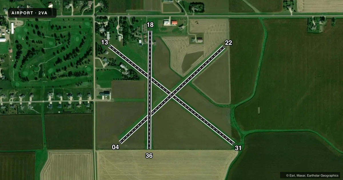
Runways & pattern
Full pagePattern entry · RWY 13
LEFT TRAFFIC| Runway | Heading (°M) | Length | Surface | Traffic |
|---|---|---|---|---|
| 13/31 | 122° / 302° | 3,146 ft | TURF | Standard L |
| 04/22 | 41° / 221° | 2,813 ft | TURF | Standard L |
| 18/36 | 174° / 354° | 2,352 ft | TURF | Standard L |
Runway end performance
| End | TORA | TODA | ASDA | LDA | VGSI | Approach lights | Obstruction |
|---|---|---|---|---|---|---|---|
| 13 | — | — | — | — | — | — | 15', tree, 25' from thr, 95' R of cntrln, slope 0 |
| 31 | — | — | — | — | — | — | 115', bldg, 2990' from thr, 50' R of cntrln, slope 26 |
Declared distances in feet. TORA = takeoff run available, TODA = takeoff distance, ASDA = accelerate-stop, LDA = landing distance.
Airport sketch
Runways drawn to scale from FAA survey coordinates, rendered over satellite imagery. Not for navigation.
Approaches & charts
Services on the field
Fuel grades, oxygen, maintenance, ramp storage and lighting — as declared to the FAA by the airport operator.
Fuel & services
- Fuel
- Not available
- Airframe repair
- Not available
- Power plant repair
- Not available
Ramp & ground
- Transient storage
- Not published
- Landing fee
- No fee published
- Wind indicator
- Yes
- Segmented circle
- No
Fuel & FBOs
Cheapest 100LL and Jet A on the field and nearby. Always confirm with the FBO before taxi.
Airport notes
Surface conditions, obstructions, local procedures, lighting outages and other notes published with each FAA cycle.
General notes
- ARPT CLSD DEC- FEB NO SNOW REMOVAL.
- FOR CD CTC MINNEAPOLIS ARTCC AT 651-463-5588.
- RWY 13 DTHR 1828 FT; EXTDS BYD RWY MIDPT.
Approach & departure obstructions
- 13MKD WITH YELLOW CONES.
- 31MKD WITH YELLOW CONES.
- 13CONTROLLING OBSTN EXCEEDS A 45 DEG SLP.
- 31SILO
Other notes
- PROVIDED APPROACH TO EACH RWY IS MAINTAINED FOR A MINIMUM 20:1 GLIDE SLOPE & THE AIRPORT TRANSITIONAL SURFACE BE MAINTAINED FOR A 7:1 SLOPE.
- 1MANAGER LIVES ONSITE 605-370-1139
- MANAGERJZANGGER@ALLIANCECOM.NET
VFR map & nearby airports
VFR sectional. Tap any ICAO chip to open that airport.
Key facts · 2VA
Answer card- ICAO
- 2VA
- Name
- ZANGGER VINTAGE AIRPARK
- Location
- LARCHWOOD, IOWA
- Elevation
- 1,478 ft MSL
- Traffic pattern altitude
- 2,478 ft MSL (1,000 AGL)
- Control tower
- Non-towered (use CTAF)
- Total runways
- 3
- Longest runway
- 13/31 · 3,146 ft
- Published ILS approaches
- 0
- Published frequencies
- 1
- Magnetic variation
- 6°
- Current flight rules
- LIFR
- Current wind
- 000° at 0 kt
- Favored runway now
- –
Zangger Vintage Airpark is in Larchwood, Iowa. Field elevation is 1,478 ft MSL. This is an uncontrolled airport with one CTAF, 122.9. There are three turf runways. The longest is runway 13/31 at 3,146 ft. No ILS approaches are published here.
Pattern altitude is not published. Use the standard 1,000 ft AGL pattern unless the current Chart Supplement says otherwise. That puts the traffic pattern at 2,478 ft MSL based on the listed field elevation. Runway 13 has a displaced threshold that starts 1,828 ft from the approach end. Runway 31 has a silo obstruction near the runway and is marked with yellow cones. Runway 13 is also marked with yellow cones.
This field is closed from December through February. There is no snow removal. That matters here because all three runways are turf. The published remarks also note that clearance delivery goes through Minneapolis ARTCC at 651-463-5588. If you need current operating details, check the current FAA Chart Supplement or call the airport operator directly. There are no on-field FBOs listed.