METAR & TAF KISB
KISB does not publish a METAR.
Showing the nearest reporting station: KSHL (SHELDON RGNL) · 10.2 NM away. Conditions at KISB may differ.
METAR · KSHL
Observed 10:35Z
KSHL 271035Z AUTO RMK AO2 PNO PWINO
- Wind
- Calm
- Visibility
- —
- Temp / Dew
- —
- Altimeter
- —
- Clouds
- Clear
- Density alt
- —
- Ceiling
- Unlimited
- Rules
- VFR
Airport info & contacts
Manager on record, flight service, ARTCC, attendance schedule and pattern altitude — published by the FAA and refreshed every 28 days.
Location
- From city
- 2 NM S
- VFR sectional
- OMAHA
- ARTCC
- ZMP · MINNEAPOLIS
- NOTAM facility
- FOD (NOTAM-D)
Airport manager
- Name
- ROBERT O'LEARY
- Phone
- 712-754-3467
- Address
- 1928 OLIVE AVENUE, SIBLEY IA 51249
Flight service · Hours
- FSS FOD
- FORT DODGE1-800-WX-BRIEF
- Attendance
- MON - FRI · 0600-1800
Frequencies
Tap any row to copy the frequency to your clipboard.
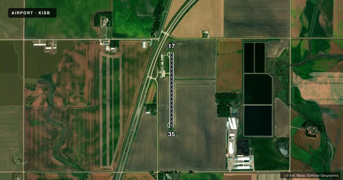
Runways & pattern
Full pagePattern entry · RWY 17
LEFT TRAFFICRunway end performance
| End | TORA | TODA | ASDA | LDA | VGSI | Approach lights | Obstruction |
|---|---|---|---|---|---|---|---|
| 17 | — | — | — | — | PAPI 2-box left(3°) | — | 15', road, 515' from thr, 206' R of cntrln, slope 21 |
| 35 | — | — | — | — | PAPI 2-box left(3°) | — | 77', trees, 1787' from thr, 51' R of cntrln, slope 20 |
Declared distances in feet. TORA = takeoff run available, TODA = takeoff distance, ASDA = accelerate-stop, LDA = landing distance.
Airport sketch
Runways drawn to scale from FAA survey coordinates, rendered over satellite imagery. Not for navigation.
Approaches & charts
Services on the field
Fuel grades, oxygen, maintenance, ramp storage and lighting — as declared to the FAA by the airport operator.
Fuel & services
- Fuel
- 100LL
- Oxygen (bottled)
- Not available
- Oxygen (bulk)
- Not available
- Airframe repair
- Minor
- Power plant repair
- Minor
- Other services
- INSTR
Ramp & ground
- Transient storage
- Tie-down
- Hangar
- Landing fee
- No fee published
- Customs
- Not available
- Lighting schedule
- SEE RMK
- Wind indicator
- Lighted
- Segmented circle
- No
Fuel & FBOs
Cheapest 100LL and Jet A on the field and nearby. Always confirm with the FBO before taxi.
Airport notes
Surface conditions, obstructions, local procedures, lighting outages and other notes published with each FAA cycle.
General notes
- RY 35 IS CALM WIND RY.
- FOR CD CTC MINNEAPOLIS ARTCC AT 651-463-5588.
Lighting notes
- ACTVT LIRL RY 17/35 AND PAPI RYS 17 & 35 - CTAF.
Runway surface & condition
- 17/35LIRL-RWY 17/35 HAVE 6 THLD LGTS EACH.
Other notes
- 1FOR ATTENDANT AFTER HOURS CALL 712-754-3467.
VFR map & nearby airports
VFR sectional. Tap any ICAO chip to open that airport.
Key facts · KISB
Answer card- ICAO
- KISB
- Name
- SIBLEY MUNI
- Location
- SIBLEY, IOWA
- Elevation
- 1,537.7 ft MSL
- Traffic pattern altitude
- 2,537.7 ft MSL (1,000 AGL)
- Control tower
- Non-towered (use CTAF)
- Total runways
- 1
- Longest runway
- 17/35 · 3,000 ft
- Published ILS approaches
- 0
- Published frequencies
- 2
- Magnetic variation
- 2°
- Current flight rules
- VFR
- Current wind
- Calm / unavailable
- Favored runway now
- –
Sibley Muni sits in Sibley, Iowa. The field elevation is 1,537.7 ft MSL. It has one runway. Runway 17/35 is 3,000 ft long and is the longest runway on the field. There is no control tower. CTAF and UNICOM are both 122.8. No ILS approaches are published here.
The pattern altitude is not published. Use the standard 1,000 ft AGL for light piston operations unless the current FAA Chart Supplement says otherwise. That puts the traffic pattern around 2,537.7 ft MSL based on the field elevation. Verify the published pattern before you fly. Runway 35 is the calm wind runway per the published remarks. Runway 17/35 has low intensity runway lights with six threshold lights on each end. Lighting for the runway and the PAPI on 17 and 35 is activated via CTAF.
O'Leary Aviation is on the field. It carries 100LL. For an attendant after hours, call the number in the remarks. This is a non-towered field with a single 3,000 ft paved runway. Plan your arrival. Make clear CTAF calls. Confirm any current procedures with the airport operator or the current FAA Chart Supplement before you go.