METAR & TAF KOTG
Current METAR
Observed 22:56Z
KOTG 272256Z AUTO 35005KT 10SM CLR 32/21 A2982 RMK AO2 SLP083 T03170211
- Wind
- 350° @ 5 kt
- Visibility
- 10 SM
- Temp / Dew
- 32°C / 21°C
- Altimeter
- 29.82 inHg
- Clouds
- CLR
- Density alt
- 4,116 ft
- Ceiling
- Unlimited
- Rules
- VFR
Airport info & contacts
Manager on record, flight service, ARTCC, attendance schedule and pattern altitude — published by the FAA and refreshed every 28 days.
Location
- From city
- 2 NM N
- VFR sectional
- OMAHA
- ARTCC
- ZMP · MINNEAPOLIS
- NOTAM facility
- OTG (NOTAM-D)
Airport manager
- Name
- TODD WIETZEMA
- Phone
- 507-372-8650
- Address
- 303 NINTH ST., BOX 279, WORTHINGTON MN 56817-0279
Flight service · Hours
- FSS PNM
- PRINCETON1-800-WX-BRIEF
- Attendance
- MON-FRI · 0800-1700
Frequencies
Tap any row to copy the frequency to your clipboard.
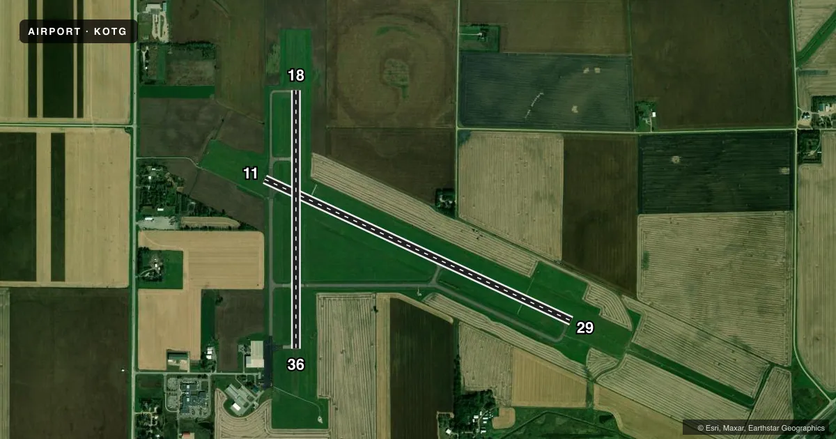
Runways & pattern
Full pagePattern entry · RWY 36
LEFT TRAFFIC| Runway | Heading (°M) | Length | Surface | Traffic |
|---|---|---|---|---|
| 11/29 | 113° / 293° | 5,500 ft | ASPH | Standard L |
| 18/36Favored | 178° / 358° | 4,200 ft | ASPH | Standard L |
Runway end performance
| End | TORA | TODA | ASDA | LDA | VGSI | Approach lights | Obstruction |
|---|---|---|---|---|---|---|---|
| 11 | — | — | — | — | PAPI 4-box left(3°) | — | — |
| 29 | — | — | — | — | PAPI 4-box left(3°) | MALSR | — |
| 18 | — | — | — | — | PAPI 4-box left(3°) | — | — |
| 36 | — | — | — | — | PAPI 4-box left(3°) | — | — |
Declared distances in feet. TORA = takeoff run available, TODA = takeoff distance, ASDA = accelerate-stop, LDA = landing distance.
Airport sketch
Runways drawn to scale from FAA survey coordinates, rendered over satellite imagery. Not for navigation.
Approaches & charts
ILS · 1
Services on the field
Fuel grades, oxygen, maintenance, ramp storage and lighting — as declared to the FAA by the airport operator.
Fuel & services
- Fuel
- 100LLA
- Oxygen (bottled)
- Not available
- Oxygen (bulk)
- Not available
- Airframe repair
- Major
- Power plant repair
- Minor
- Other services
- AGRI,INSTR,RNTL,SALES
Ramp & ground
- Transient storage
- Tie-down
- Hangar
- Landing fee
- No fee published
- Customs
- Not available
- Lighting schedule
- SEE RMK
- Beacon schedule
- SS-SR
- Beacon
- White / Green (civil land)(WG)
- Wind indicator
- Lighted
- Segmented circle
- Yes
Fuel & FBOs
Cheapest 100LL and Jet A on the field and nearby. Always confirm with the FBO before taxi.
Airport notes
Surface conditions, obstructions, local procedures, lighting outages and other notes published with each FAA cycle.
Lighting notes
- ACTVT MALSR RWY 29; REIL RWY 11, 18 & 36; PAPI RWY 18 & 36; MIRL RWY 18/36 - CTAF. HIRL RWY 11/29 PRESET ON LOW INTST; TO INCR INTST - CTAF. PAPI RWY 11 & 29 OPR CONSLY.
Fuel notes
- 100LLSELF SVC FUEL WITH CREDIT CARD.
- ASELF SVC FUEL AVBL WITH CREDIT CARD. JET A TRUCK AVBL WHEN ATNDD.
Other notes
- 1FOR SVC CALL 507-376-9293; AFT HRS CALL 507-360-3731.
- MANAGERCAMERON JOHNSON - 507-376-9293.
VFR map & nearby airports
VFR sectional. Tap any ICAO chip to open that airport.
Key facts · KOTG
Answer card- ICAO
- KOTG
- Name
- WORTHINGTON MUNI
- Location
- WORTHINGTON, MINNESOTA
- Elevation
- 1,574 ft MSL
- Traffic pattern altitude
- 2,574 ft MSL (1,000 AGL)
- Control tower
- Non-towered (use CTAF)
- Total runways
- 2
- Longest runway
- 11/29 · 5,500 ft
- Published ILS approaches
- 1
- Published frequencies
- 2
- Magnetic variation
- 2°
- Current flight rules
- VFR
- Current wind
- 350° at 5 kt
- Favored runway now
- RWY 36
Worthington Muni sits in Worthington, Minnesota. The field elevation is 1,574 ft MSL. It has two asphalt runways. The longest is 5,500 ft on runway 11/29. There is no control tower, so expect CTAF and UNICOM self-announce traffic. CTAF and UNICOM are both 122.8.
Runway 29 has the published ILS approach. The field also has lighting that matters for night work. MALSR is available for runway 29. REIL is available for 11, 18 and 36. PAPI is available for 18, 36, 11 and 29. Runway 18 and 36 lighting is medium intensity and controlled on CTAF. Runway 11/29 lighting starts at low intensity. You can ask for more intensity on CTAF.
Pattern altitude is not published in the facts. Use standard 1,000 ft AGL unless the current Chart Supplement says otherwise. Integrity Aviation is on the field. It carries 100LL, Jet A and Jet A Prist. Self-serve fuel is available with credit card. For service, call the FBO directly. The airport manager contact is Cameron Johnson at the same number. For a first-time arrival, pay attention to the lighting setup on 29 and the higher field elevation. Density altitude can matter here in warm weather.