METAR & TAF KMJQ
Current METAR
Observed 01:15Z
KMJQ 140115Z AUTO 34015G20KT 10SM SCT065 20/07 A2996 RMK AO2
- Wind
- 340° @ 15G20 kt
- Visibility
- 10 SM
- Temp / Dew
- 20°C / 7°C
- Altimeter
- 29.96 inHg
- Clouds
- SCT
- Density alt
- 2,343 ft
- Ceiling
- Unlimited
- Rules
- VFR
Airport info & contacts
Manager on record, flight service, ARTCC, attendance schedule and pattern altitude — published by the FAA and refreshed every 28 days.
Location
- From city
- 2 NM N
- VFR sectional
- OMAHA
- ARTCC
- ZMP · MINNEAPOLIS
- NOTAM facility
- MJQ (NOTAM-D)
Airport manager
- Name
- PAUL SANDERS, PS AVIATION, INC.
- Phone
- 507-847-3599
- Address
- 150 COUNTY ROAD 34 E, JACKSON MN 56143-3164
Flight service · Hours
- FSS PNM
- PRINCETON1-800-WX-BRIEF
- Attendance
- MON-FRI · 0800-1700
Frequencies
Tap any row to copy the frequency to your clipboard.
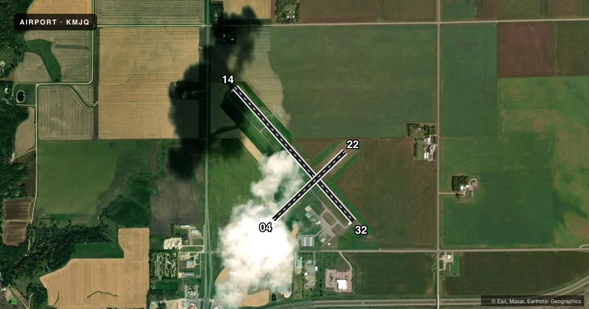
Runways & pattern
Full pagePattern entry · RWY 32
LEFT TRAFFIC| Runway | Heading (°M) | Length | Surface | Traffic |
|---|---|---|---|---|
| 14/32Favored | 134° / 314° | 4,145 ft | ASPH | Standard L |
| 04/22 | 43° / 223° | 2,282 ft | TURF | Standard L |
Runway end performance
| End | TORA | TODA | ASDA | LDA | VGSI | Approach lights | Obstruction |
|---|---|---|---|---|---|---|---|
| 14 | 3,600' | 3,600' | 4,145' | 3,600' | PAPI 4-box left(3°) | — | — |
| 32 | 3,600' | 3,600' | 4,145' | 3,600' | PAPI 4-box left(3°) | — | — |
| 22 | — | — | — | — | — | — | 7', crops, 46' from thr, 129' R of cntrln, slope 6 |
Declared distances in feet. TORA = takeoff run available, TODA = takeoff distance, ASDA = accelerate-stop, LDA = landing distance.
Airport sketch
Runways drawn to scale from FAA survey coordinates, rendered over satellite imagery. Not for navigation.
Approaches & charts
Services on the field
Fuel grades, oxygen, maintenance, ramp storage and lighting — as declared to the FAA by the airport operator.
Fuel & services
- Fuel
- 100LLA
- Oxygen (bottled)
- Not available
- Oxygen (bulk)
- Not available
- Airframe repair
- Major
- Power plant repair
- Major
- Other services
- AGRI,RNTL
Ramp & ground
- Transient storage
- Tie-down
- Hangar
- Landing fee
- No fee published
- Customs
- Not available
- Lighting schedule
- SEE RMK
- Beacon schedule
- SS-SR
- Beacon
- White / Green (civil land)(WG)
- Wind indicator
- Lighted
- Segmented circle
- No
Fuel & FBOs
Cheapest 100LL and Jet A on the field and nearby. Always confirm with the FBO before taxi.
Airport notes
Surface conditions, obstructions, local procedures, lighting outages and other notes published with each FAA cycle.
General notes
- GCO AVBL ON FREQ 121.725 THRU MINNEAPOLIS ARTCC & FLT SVCS
- ACCESS CODE TO A/D BLDG IS CTAF FREQ.
- FOR CD IF UNA VIA GCO CTC MINNEAPOLIS ARTCC AT 651-463-5588.
Lighting notes
- ACTVT OR INCR INTST REIL RWY 14 & 32; PAPI RWY 14 & 32; MIRL RWY 14/32 - CTAF. MIRL RWY 14/32 PRESET LOW INTST.
Fuel notes
- 100LLFUEL AVBL H24 VIA CREDIT CARD.
Runway surface & condition
- 04/22CLSD WINTER MONTHS.
Approach & departure obstructions
- 04YELLOW CONES.
- 22YELLOW CONES.
- 14RWY 14 PAPI UNUSBL BYD 6 DEGS LEFT OF CRS.
Other notes
- 1FOR SVC AFT HRS CALL 507-447-2675.
VFR map & nearby airports
VFR sectional. Tap any ICAO chip to open that airport.
Key facts · KMJQ
Answer card- ICAO
- KMJQ
- Name
- JACKSON MUNI
- Location
- JACKSON, MINNESOTA
- Elevation
- 1,445.7 ft MSL
- Traffic pattern altitude
- 2,445.7 ft MSL (1,000 AGL)
- Control tower
- Non-towered (use CTAF)
- Total runways
- 2
- Longest runway
- 14/32 · 4,145 ft
- Published ILS approaches
- 0
- Published frequencies
- 2
- Magnetic variation
- 4°
- Current flight rules
- VFR
- Current wind
- 340° at 15 kt
- Favored runway now
- RWY 32
Jackson Muni sits in Jackson, Minnesota. Field elevation is 1,445.7 ft MSL. The airport has two runways. The longest is 14/32 at 4,145 ft. Runway 04/22 is turf and closes during winter months. There is no control tower. CTAF and UNICOM are both 122.8.
No ILS approaches are published here. Pattern altitude is not published in the facts, so use standard 1,000 ft AGL for light piston operations unless the current FAA Chart Supplement says otherwise. That puts the pattern at about 2,446 ft MSL based on the field elevation.
PS Aviation is on the field. It carries 100LL and Jet A. Fuel is available 24 hours via credit card. The airport building access code is the CTAF frequency. After hours service is listed by phone in the Chart Supplement remarks.
A few runway notes matter here. Runway 14 has a PAPI, but it is unusable beyond 6 degrees left of course. Runway 14/32 has medium intensity lights controlled by CTAF, with the lights preset to low intensity. Yellow cones mark the ends of 04 and 22. This is a non-towered field in southwest Minnesota, so plan your self-announce work carefully and verify current field status before you go.