METAR & TAF 8Y8
8Y8 does not publish a METAR.
Showing the nearest reporting station: KEST (ESTHERVILLE MUNI) · 11.7 NM away. Conditions at 8Y8 may differ.
METAR · KEST
Observed 16:49Z
KEST 271649Z AUTO 36006KT 10SM CLR 29/22 A2981 RMK AO2 SLP081 T02890222
- Wind
- 360° @ 6 kt
- Visibility
- 10 SM
- Temp / Dew
- 29°C / 22°C
- Altimeter
- 29.81 inHg
- Clouds
- CLR
- Density alt
- 3,404 ft
- Ceiling
- Unlimited
- Rules
- VFR
Airport info & contacts
Manager on record, flight service, ARTCC, attendance schedule and pattern altitude — published by the FAA and refreshed every 28 days.
Location
- From city
- 3 NM SW
- VFR sectional
- OMAHA
- ARTCC
- ZMP · MINNEAPOLIS
- NOTAM facility
- 8Y8 (NOTAM-D)
Airport manager
- Name
- MATT PELTZ
- Phone
- (612) 799-8797
- Address
- 7501 TERRITORY PASS, LAKEVILLE MN 55044
Flight service · Hours
- FSS FOD
- FORT DODGE1-800-WX-BRIEF
Frequencies
Tap any row to copy the frequency to your clipboard.
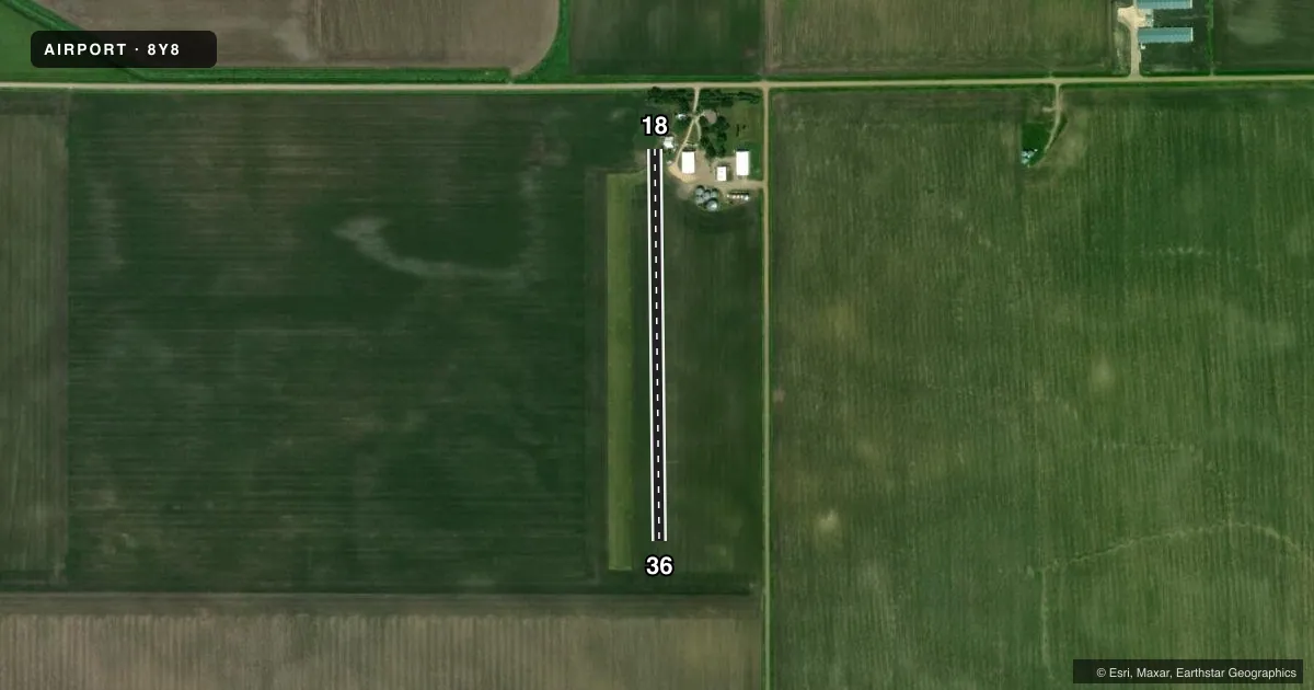
Runways & pattern
Full pagePattern entry · RWY 36
LEFT TRAFFICRunway end performance
| End | TORA | TODA | ASDA | LDA | VGSI | Approach lights | Obstruction |
|---|---|---|---|---|---|---|---|
| 18 | — | — | — | — | — | — | 15', road, 450' from thr, 0' R of cntrln, slope 30 |
Declared distances in feet. TORA = takeoff run available, TODA = takeoff distance, ASDA = accelerate-stop, LDA = landing distance.
Airport sketch
Runways drawn to scale from FAA survey coordinates, rendered over satellite imagery. Not for navigation.
Approaches & charts
Services on the field
Fuel grades, oxygen, maintenance, ramp storage and lighting — as declared to the FAA by the airport operator.
Fuel & services
- Fuel
- Not available
Ramp & ground
- Transient storage
- Not published
Fuel & FBOs
Cheapest 100LL and Jet A on the field and nearby. Always confirm with the FBO before taxi.
Airport notes
Surface conditions, obstructions, local procedures, lighting outages and other notes published with each FAA cycle.
General notes
- NO SNOW REMOVAL. ARPT CLSD WHEN SNOW CONDITIONS EXIST.
- FOR CD CTC MINNEAPOLIS ARTCC AT 651-463-5588.
Other notes
- OWNERMATTPELTZ@GMAIL.COM (ALL LOWER CASE)
VFR map & nearby airports
VFR sectional. Tap any ICAO chip to open that airport.
Key facts · 8Y8
Answer card- ICAO
- 8Y8
- Name
- PELTZ FLD
- Location
- RINGSTED, IOWA
- Elevation
- 1,280 ft MSL
- Traffic pattern altitude
- 2,280 ft MSL (1,000 AGL)
- Control tower
- Non-towered (use CTAF)
- Total runways
- 1
- Longest runway
- 18/36 · 2,040 ft
- Published ILS approaches
- 0
- Published frequencies
- 1
- Magnetic variation
- –
- Current flight rules
- VFR
- Current wind
- 360° at 6 kt
- Favored runway now
- RWY 36
Peltz Fld sits near Ringsted, Iowa. The field elevation is 1,280 ft MSL. It has one runway. Runway 18/36 is 2,040 ft long and turf. There is no control tower. CTAF is 122.9. No ILS approaches are published here.
The published pattern altitude is not listed, so use the standard 1,000 ft AGL unless the current Chart Supplement says otherwise. That puts the traffic pattern at 2,280 ft MSL based on the field elevation. For clearance delivery, Minneapolis ARTCC is listed in the remarks. The airport also notes that no snow removal is provided. It is closed when snow conditions exist. That matters here because this is a turf strip in Iowa. Surface condition can end the day fast.
There are no on-field FBOs listed. If you need current fuel or services, contact the airport operator directly before departure. The remarks also list the owner contact in the Chart Supplement. With no tower and no published ILS, plan conservatively and verify current field conditions before you go.