METAR & TAF KSBU
KSBU does not publish a METAR.
Showing the nearest reporting station: KFRM (FAIRMONT MUNI) · 14.3 NM away. Conditions at KSBU may differ.
METAR · KFRM
Observed 19:56Z
KFRM 271956Z AUTO 34012KT 10SM CLR 31/19 A2979 RMK AO2 SLPNO T03110189
- Wind
- 340° @ 12 kt
- Visibility
- 10 SM
- Temp / Dew
- 31°C / 19°C
- Altimeter
- 29.79 inHg
- Clouds
- CLR
- Density alt
- 3,454 ft
- Ceiling
- Unlimited
- Rules
- VFR
Airport info & contacts
Manager on record, flight service, ARTCC, attendance schedule and pattern altitude — published by the FAA and refreshed every 28 days.
Location
- From city
- 3 NM S
- VFR sectional
- OMAHA
- ARTCC
- ZMP · MINNEAPOLIS
- NOTAM facility
- PNM (NOTAM-D)
Airport manager
- Name
- LUKE STEIER
- Phone
- 507-526-7264
- Address
- 7575 HWY 169, BLUE EARTH MN 56013
Flight service · Hours
- FSS PNM
- PRINCETON1-800-WX-BRIEF
- Attendance
- MON-FRI · 0800-1700
Frequencies
Tap any row to copy the frequency to your clipboard.
Runways & pattern
Full pagePattern entry · RWY 34
LEFT TRAFFIC| Runway | Heading (°M) | Length | Surface | Traffic |
|---|---|---|---|---|
| 16/34Favored | 160° / 340° | 3,400 ft | CONC | Standard L |
| 03/21 | 34° / 214° | 2,245 ft | TURF | Standard L |
Runway end performance
| End | TORA | TODA | ASDA | LDA | VGSI | Approach lights | Obstruction |
|---|---|---|---|---|---|---|---|
| 16 | — | — | — | — | PAPI 4-box left(3°) | — | — |
| 34 | — | — | — | — | PAPI 4-box left(3°) | — | — |
Declared distances in feet. TORA = takeoff run available, TODA = takeoff distance, ASDA = accelerate-stop, LDA = landing distance.
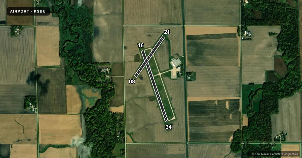
Airport sketch
Runways drawn to scale from FAA survey coordinates, rendered over satellite imagery. Not for navigation.
Approaches & charts
Services on the field
Fuel grades, oxygen, maintenance, ramp storage and lighting — as declared to the FAA by the airport operator.
Fuel & services
- Fuel
- 100LLA
- Oxygen (bottled)
- Not available
- Oxygen (bulk)
- Not available
- Airframe repair
- Minor
- Power plant repair
- Minor
- Other services
- AGRI
Ramp & ground
- Transient storage
- Tie-down
- Landing fee
- No fee published
- Customs
- Not available
- Lighting schedule
- SEE RMK
- Beacon schedule
- SS-SR
- Beacon
- White / Green (civil land)(WG)
- Wind indicator
- Lighted
- Segmented circle
- No
Fuel & FBOs
Cheapest 100LL and Jet A on the field and nearby. Always confirm with the FBO before taxi.
Airport notes
Surface conditions, obstructions, local procedures, lighting outages and other notes published with each FAA cycle.
General notes
- RY 03/21 CLSD WINTER MONTHS
- DEER & WATERFOWL ON & INVOF ARPT.
- GCO AVBL ON FREQ 121.725 THRU MINNEAPOLIS ARTCC & FLT SVCS.
- FOR CD IF UNA VIA GCO CTC MINNEAPOLIS ARTCC AT 651-463-5588.
Lighting notes
- RWY 16-34 MIRL PRESET TO LOW SS-SR, TO INCR INTS AND ACTVT PAPI RY 16 & RY 34, AND REIL RY 16 & RY 34 - CTAF.
Fuel notes
- 100LLSELF SERVICE FUEL AVAILABLE WITH CREDIT CARD
Approach & departure obstructions
- 16RWY 16 HAS 4 FT BRUSH 35 FT FM THE RWY END AND 154 FT LEFT.
- 03MKD WITH YELLOW CONES.
Other notes
- 1FOR SVC AFT HRS CALL 507-525-3064
- MANAGEREMAIL ADDRESS: STEIERL@HOTMAIL.COM (ALL LOWER CASE)
VFR map & nearby airports
VFR sectional. Tap any ICAO chip to open that airport.
Key facts · KSBU
Answer card- ICAO
- KSBU
- Name
- BLUE EARTH MUNI
- Location
- BLUE EARTH, MINNESOTA
- Elevation
- 1,107.4 ft MSL
- Traffic pattern altitude
- 2,107.4 ft MSL (1,000 AGL)
- Control tower
- Non-towered (use CTAF)
- Total runways
- 2
- Longest runway
- 16/34 · 3,400 ft
- Published ILS approaches
- 0
- Published frequencies
- 2
- Magnetic variation
- 1°
- Current flight rules
- VFR
- Current wind
- 340° at 12 kt
- Favored runway now
- RWY 34
Blue Earth Muni Airport (KSBU) sits in Blue Earth, Minnesota. The field elevation is 1,107.4 ft MSL. It has two runways. The longest is Runway 16/34 at 3,400 ft of concrete. Runway 03/21 is 2,245 ft of turf. There is no control tower. CTAF and UNICOM are both 122.8. No ILS approaches are published here.
The published pattern altitude is not listed, so use the standard 1,000 ft AGL for light piston operations unless the current Chart Supplement says otherwise. That puts the traffic pattern around 2,107.4 ft MSL based on the field elevation. The on-field FBO is Blue Earth Municipal Airport. It carries AVGAS 100LL and JET A. Self-serve 100LL is available with a credit card. For service after hours, call the number in the remarks. Runway 03/21 is closed during the winter months. Runway 03 is marked with yellow cones.
The airport also has a few items worth planning for. Deer and waterfowl are reported on and near the field. Runway 16 has brush close to the departure end on the left side. Runway 16/34 lighting is set low from sunset to sunrise. Use CTAF to increase intensity and activate the PAPI and runway end identifier lights. If you need clearance delivery and ground communications are not available, contact Minneapolis ARTCC. Check the current Chart Supplement before departure for any updated procedures.