METAR & TAF 68Y
68Y does not publish a METAR.
Showing the nearest reporting station: KAEL (ALBERT LEA MUNI) · 18.1 NM away. Conditions at 68Y may differ.
METAR · KAEL
Observed 20:35Z
KAEL 272035Z AUTO 32005KT 10SM CLR 32/22 A2975 RMK AO2 T03200220
- Wind
- 320° @ 5 kt
- Visibility
- 10 SM
- Temp / Dew
- 32°C / 22°C
- Altimeter
- 29.75 inHg
- Clouds
- CLR
- Density alt
- 3,638 ft
- Ceiling
- Unlimited
- Rules
- VFR
Airport info & contacts
Manager on record, flight service, ARTCC, attendance schedule and pattern altitude — published by the FAA and refreshed every 28 days.
Location
- From city
- 2 NM W
- VFR sectional
- OMAHA
- ARTCC
- ZMP · MINNEAPOLIS
- NOTAM facility
- PNM (NOTAM-D)
Airport manager
- Name
- CITY ADMINISTRATOR
- Phone
- 507-553-6371
- Address
- 125 S BROADWAY, WELLS MN 56097-1627
Flight service · Hours
- FSS PNM
- PRINCETON1-800-WX-BRIEF
- Attendance
- MAY-OCT · MON-FRI · 0730-2000
- NOV-APR · MON-FRI · 0800-1700
Frequencies
Tap any row to copy the frequency to your clipboard.
Runways & pattern
Full pagePattern entry · RWY 35
LEFT TRAFFICRunway end performance
| End | TORA | TODA | ASDA | LDA | VGSI | Approach lights | Obstruction |
|---|---|---|---|---|---|---|---|
| 17 | — | — | — | — | — | — | 18', road, 498' from thr, 0' R of cntrln, slope 27 |
Declared distances in feet. TORA = takeoff run available, TODA = takeoff distance, ASDA = accelerate-stop, LDA = landing distance.
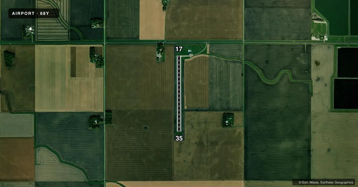
Airport sketch
Runways drawn to scale from FAA survey coordinates, rendered over satellite imagery. Not for navigation.
Approaches & charts
Services on the field
Fuel grades, oxygen, maintenance, ramp storage and lighting — as declared to the FAA by the airport operator.
Fuel & services
- Fuel
- 100LL
- Oxygen (bottled)
- Not available
- Oxygen (bulk)
- Not available
- Airframe repair
- Major
- Power plant repair
- Major
- Other services
- AGRI,SALES
Ramp & ground
- Transient storage
- Tie-down
- Landing fee
- No fee published
- Lighting schedule
- SS-SR
- Beacon schedule
- SS-SR
- Beacon
- White / Green (civil land)(WG)
- Wind indicator
- Lighted
- Segmented circle
- No
Fuel & FBOs
Cheapest 100LL and Jet A on the field and nearby. Always confirm with the FBO before taxi.
Airport notes
Surface conditions, obstructions, local procedures, lighting outages and other notes published with each FAA cycle.
General notes
- FOR CD CTC MINNEAPOLIS ARTCC AT 651-463-5588.
Fuel notes
- 100LL100LL AVBL FM FUEL TRUCK, FOR SVC AFT HRS CALL 507-553-3100.
Runway surface & condition
- 17/35NSTD LIRL DUE TO SPACING.
Approach & departure obstructions
- 17YELLOW CONES.
- 35YELLOW CONES.
VFR map & nearby airports
VFR sectional. Tap any ICAO chip to open that airport.
Key facts · 68Y
Answer card- ICAO
- 68Y
- Name
- WELLS MUNI
- Location
- WELLS, MINNESOTA
- Elevation
- 1,119 ft MSL
- Traffic pattern altitude
- 2,119 ft MSL (1,000 AGL)
- Control tower
- Non-towered (use CTAF)
- Total runways
- 1
- Longest runway
- 17/35 · 2,897 ft
- Published ILS approaches
- 0
- Published frequencies
- 1
- Magnetic variation
- –
- Current flight rules
- VFR
- Current wind
- 320° at 5 kt
- Favored runway now
- RWY 35
Wells Muni sits in Wells, Minnesota. The field elevation is 1,119 ft MSL. It has one runway. Runway 17/35 is a 2,897 ft turf strip. The airport is non-towered, so CTAF 122.9 is the main frequency for traffic calls.
No ILS approaches are published here. The pattern altitude is not published. For light piston traffic, plan on the standard 1,000 ft AGL pattern unless the current FAA Chart Supplement says otherwise. Wells Aviation is on the field. It carries AVGAS 100LL. Fuel is available from the fuel truck. Call the FBO at (507) 553-3100 for after-hours service.
A few published remarks matter here. Yellow cones mark the ends of both runway 17 and runway 35. Nonstandard low intensity runway lights are installed because of spacing. If you need clearance delivery, Minneapolis ARTCC handles that at 651-463-5588. For a first visit, treat this as a small turf field with limited approach support. Check runway condition. Check lighting status. Check wind before you go. The turf surface and 2,897 ft length make technique and performance planning important, especially when the field is soft or the wind is not aligned with the runway.