METAR & TAF 0Y6
0Y6 does not publish a METAR.
Showing the nearest reporting station: KFXY (FOREST CITY MUNI/TRIMBLE FLD) · 11.8 NM away. Conditions at 0Y6 may differ.
METAR · KFXY
Observed 18:55Z
KFXY 271855Z AUTO 30012KT 10SM CLR 32/20 A2977 RMK AO2
- Wind
- 300° @ 12 kt
- Visibility
- 10 SM
- Temp / Dew
- 32°C / 20°C
- Altimeter
- 29.77 inHg
- Clouds
- CLR
- Density alt
- 3,788 ft
- Ceiling
- Unlimited
- Rules
- VFR
Airport info & contacts
Manager on record, flight service, ARTCC, attendance schedule and pattern altitude — published by the FAA and refreshed every 28 days.
Location
- From city
- 1 NM E
- VFR sectional
- OMAHA
- ARTCC
- ZMP · MINNEAPOLIS
- NOTAM facility
- FOD (NOTAM-D)
Airport manager
- Name
- BRAD WEMPEN
- Phone
- 641-592-2441
- Address
- 200 N 1ST AVE. W, LAKE MILLS IA 50450
Flight service · Hours
- FSS FOD
- FORT DODGE1-800-WX-BRIEF
- Attendance
- Unattended
Frequencies
Tap any row to copy the frequency to your clipboard.
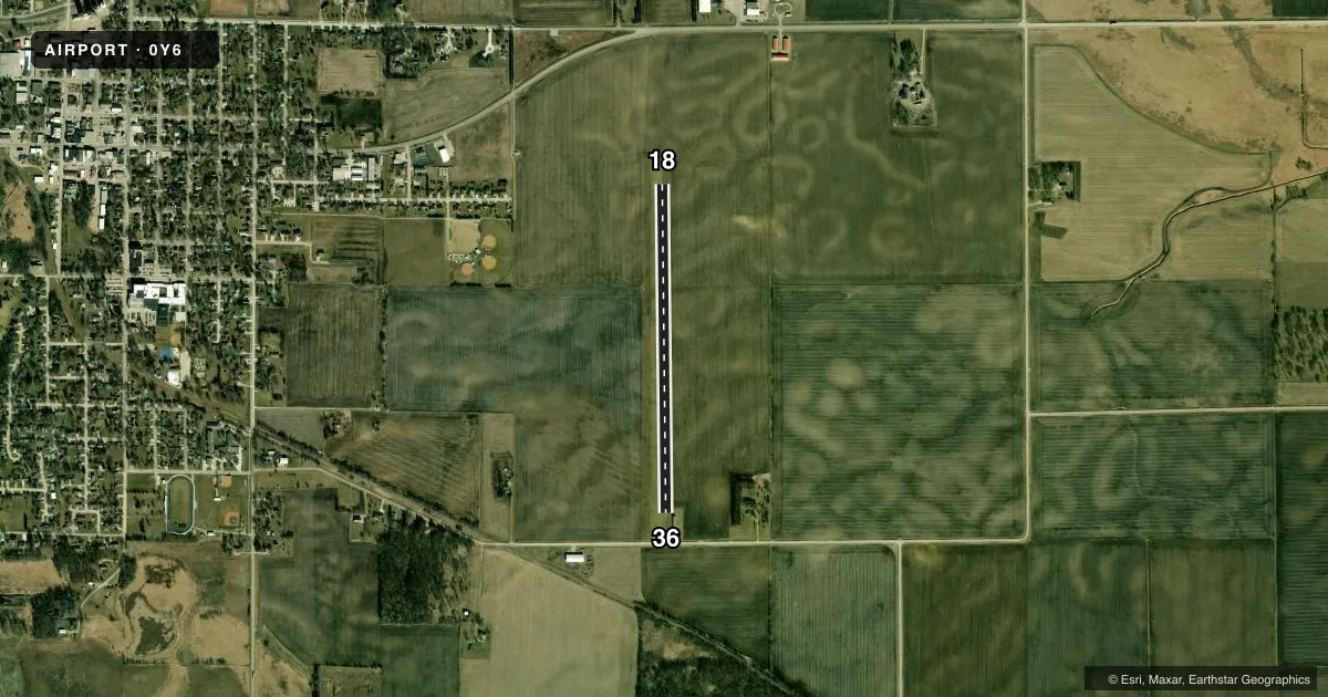
Runways & pattern
Full pagePattern entry · RWY 36
LEFT TRAFFICRunway end performance
| End | TORA | TODA | ASDA | LDA | VGSI | Approach lights | Obstruction |
|---|---|---|---|---|---|---|---|
| 18 | — | — | — | — | — | — | 57', trees, 2157' from thr, 100' R of cntrln, slope 37 |
| 36 | — | — | — | — | — | — | 96', trees, 1734' from thr, 100' R of cntrln, slope 18 |
Declared distances in feet. TORA = takeoff run available, TODA = takeoff distance, ASDA = accelerate-stop, LDA = landing distance.
Airport sketch
Runways drawn to scale from FAA survey coordinates, rendered over satellite imagery. Not for navigation.
Approaches & charts
Services on the field
Fuel grades, oxygen, maintenance, ramp storage and lighting — as declared to the FAA by the airport operator.
Fuel & services
- Fuel
- Not available
- Oxygen (bottled)
- Not available
- Oxygen (bulk)
- Not available
- Airframe repair
- Not available
- Power plant repair
- Not available
Ramp & ground
- Transient storage
- Tie-down
- Landing fee
- No fee published
- Lighting schedule
- SS-SR
- Beacon schedule
- SS-SR
- Beacon
- White / Green (civil land)(WG)
- Wind indicator
- Lighted
- Segmented circle
- No
Fuel & FBOs
Cheapest 100LL and Jet A on the field and nearby. Always confirm with the FBO before taxi.
Airport notes
Surface conditions, obstructions, local procedures, lighting outages and other notes published with each FAA cycle.
General notes
- ARPT CLSD NOV 15 - MAR 31.
- TELEPHONE IN HANGAR - LOCAL CALLS ONLY.
- FOR CD CTC MINNEAPOLIS ARTCC AT 651-463-5588.
Runway surface & condition
- 18/36RWY EDGES MKD WITH SOLAR LGTS ON YELLOW CONES.
Approach & departure obstructions
- 18& 36 THLDS & EDGES MARKED WITH YELLOW CONES.
- 36RWY 18/36 MKD WITH YELLOW CONES.
- 36APCH RATIO 20:1 TO DSPLCD THLD.
Other notes
- PROVIDED APCH TO EACH RWY IS MAINTAINED FOR A MIN 20:1 GLIDE SLOPE AND THE TRANSITIONAL SURFACE BE MAINTAINED FOR A 7:1 SLOPE.
VFR map & nearby airports
VFR sectional. Tap any ICAO chip to open that airport.
Key facts · 0Y6
Answer card- ICAO
- 0Y6
- Name
- LAKE MILLS MUNI
- Location
- LAKE MILLS, IOWA
- Elevation
- 1,260 ft MSL
- Traffic pattern altitude
- 2,260 ft MSL (1,000 AGL)
- Control tower
- Non-towered (use CTAF)
- Total runways
- 1
- Longest runway
- 18/36 · 3,380 ft
- Published ILS approaches
- 0
- Published frequencies
- 1
- Magnetic variation
- 4°
- Current flight rules
- VFR
- Current wind
- 300° at 12 kt
- Favored runway now
- RWY 36
Lake Mills Muni sits in Lake Mills, Iowa. The field elevation is 1,260 ft MSL. It has one runway, 18/36, which is 3,380 ft of turf. There is no control tower. CTAF is 122.9. No ILS approaches are published here, so plan on visual work or other non-ILS options if you are operating in lower weather.
Pattern altitude is not published. Use 1,000 ft AGL for light piston operations unless the current Chart Supplement says otherwise. That puts the standard pattern at 2,260 ft MSL. The airport is closed from November 15 through March 31, so check the current Chart Supplement before planning a trip in that window. The runway is marked with yellow cones. Runway edges also use solar lights on yellow cones. The published remarks also note a 20 to 1 approach surface to the displaced threshold on runway 36.
There are no on-field FBOs listed. Contact the airport operator directly before arrival if you need local services. For clearance delivery, Minneapolis ARTCC handles that work at 651-463-5588. The hangar phone is for local calls only. If you are coming in for the first time, treat this as a small turf field with seasonal closure and limited published approach support. Verify current conditions before you launch.