METAR & TAF KFRM
Current METAR
Observed 14:56Z
KFRM 271456Z AUTO 34009KT 10SM CLR 28/23 A2979 RMK AO2 SLP081 T02830228 53005
- Wind
- 340° @ 9 kt
- Visibility
- 10 SM
- Temp / Dew
- 28°C / 23°C
- Altimeter
- 29.79 inHg
- Clouds
- CLR
- Density alt
- 3,162 ft
- Ceiling
- Unlimited
- Rules
- VFR
Airport info & contacts
Manager on record, flight service, ARTCC, attendance schedule and pattern altitude — published by the FAA and refreshed every 28 days.
Location
- From city
- 2 NM SE
- VFR sectional
- OMAHA
- ARTCC
- ZMP · MINNEAPOLIS
- NOTAM facility
- FRM (NOTAM-D)
Airport manager
- Name
- LEE STEINKAMP
- Phone
- 507-235-6160
- Address
- 2159 EAST BLUE EARTH AVE, FAIRMONT MN 56031
Flight service · Hours
- FSS PNM
- PRINCETON1-800-WX-BRIEF
- Attendance
- MON-FRI · 0800-1700
Frequencies
Tap any row to copy the frequency to your clipboard.
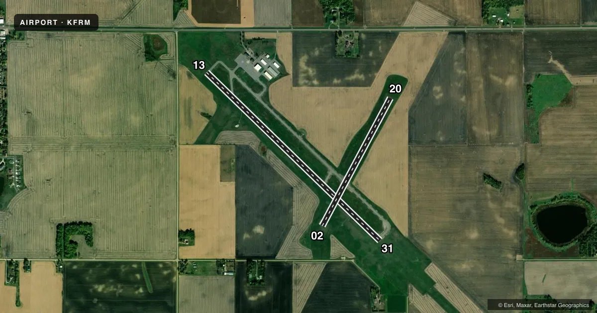
Runways & pattern
Full pagePattern entry · RWY 31
LEFT TRAFFIC| Runway | Heading (°M) | Length | Surface | Traffic |
|---|---|---|---|---|
| 13/31Favored | 130° / 310° | 5,505 ft | ASPH | Standard L |
| 02/20 | 24° / 204° | 3,301 ft | ASPH | Standard L |
Runway end performance
| End | TORA | TODA | ASDA | LDA | VGSI | Approach lights | Obstruction |
|---|---|---|---|---|---|---|---|
| 13 | — | — | — | — | PAPI 4-box left(3°) | — | 9', road, 405' from thr, 520' R of cntrln, slope 22 |
| 31 | — | — | — | — | PAPI 4-box left(3°) | MALSR | — |
| 02 | — | — | — | — | PAPI 4-box left(3°) | — | — |
| 20 | — | — | — | — | PAPI 4-box left(3°) | — | — |
Declared distances in feet. TORA = takeoff run available, TODA = takeoff distance, ASDA = accelerate-stop, LDA = landing distance.
Airport sketch
Runways drawn to scale from FAA survey coordinates, rendered over satellite imagery. Not for navigation.
Approaches & charts
ILS · 1
Services on the field
Fuel grades, oxygen, maintenance, ramp storage and lighting — as declared to the FAA by the airport operator.
Fuel & services
- Fuel
- 100LLA
- Oxygen (bottled)
- Not available
- Oxygen (bulk)
- Not available
- Airframe repair
- Not available
- Power plant repair
- Not available
- Other services
- AGRI,SALES
Ramp & ground
- Transient storage
- Tie-down
- Hangar
- Landing fee
- No fee published
- Customs
- Not available
- Lighting schedule
- SEE RMK
- Beacon schedule
- SS-SR
- Beacon
- White / Green (civil land)(WG)
- Wind indicator
- Lighted
- Segmented circle
- Yes
Fuel & FBOs
Cheapest 100LL and Jet A on the field and nearby. Always confirm with the FBO before taxi.
Airport notes
Surface conditions, obstructions, local procedures, lighting outages and other notes published with each FAA cycle.
General notes
- MIGRATORY BIRD HAZARD SPRING & FALL; GULLS ON & INVOF ARPT.
- FOR TWY LGTS KEY 122.8 3 TIMES FOR 30% AND 7 TIMES FOR 100%.
- FOR TRANSIENT STORAGE CTC AMGR.
Lighting notes
- HIRL RWY 13/31 AND MIRL RWY 02/20 PRESET TO LOW INTS, TO INCR INTS AND ACTVT MALSR RWY 31; REIL RWY 02, 13, & 20; PAPI RWY 02, 13, 20, & 31 - CTAF.
Fuel notes
- 100LLJET A & 100LL AVBL 24 HRS WITH CREDIT CARD.
Other notes
- 02/20WEEDS GROWING THRU LRG CRACKS.
VFR map & nearby airports
VFR sectional. Tap any ICAO chip to open that airport.
Key facts · KFRM
Answer card- ICAO
- KFRM
- Name
- FAIRMONT MUNI
- Location
- FAIRMONT, MINNESOTA
- Elevation
- 1,161.8 ft MSL
- Traffic pattern altitude
- 2,161.8 ft MSL (1,000 AGL)
- Control tower
- Non-towered (use CTAF)
- Total runways
- 2
- Longest runway
- 13/31 · 5,505 ft
- Published ILS approaches
- 1
- Published frequencies
- 2
- Magnetic variation
- 4°
- Current flight rules
- VFR
- Current wind
- 340° at 9 kt
- Favored runway now
- RWY 31
Fairmont Muni sits in Fairmont, Minnesota. The field elevation is 1,161.8 ft MSL. It has two asphalt runways. The longest is 5,505 ft on 13/31. The airport is not towered. CTAF and UNICOM are both 122.8. One ILS approach is published for runway 31.
Pattern altitude is not published. Use 1,000 ft AGL for light piston traffic unless the current Chart Supplement says otherwise. That puts the standard pattern at 2,161.8 ft MSL based on the listed field elevation. The on-field FBO is Fairmont Municipal Airport. It carries 100LL and Jet A. Fuel is available 24 hours with credit card. Call the airport manager for transient storage.
A first-time pilot should pay attention to the runway lighting setup. Runway 13/31 has high intensity lights. Runway 02/20 has medium intensity lights. The approach lighting for runway 31 is activated from CTAF. Taxiway lights also use CTAF keying. Spring and fall bring a migratory bird hazard, with gulls on and near the airport. Runway 02/20 also has weeds growing through large cracks, so expect a rougher surface there. If you need current operational details, check the current FAA Chart Supplement or call the airport operator before departure.