METAR & TAF KJYG
Current METAR
Observed 21:55Z
KJYG 272155Z AUTO 33007KT 10SM CLR 31/24 A2976 RMK AO2
- Wind
- 330° @ 7 kt
- Visibility
- 10 SM
- Temp / Dew
- 31°C / 24°C
- Altimeter
- 29.76 inHg
- Clouds
- CLR
- Density alt
- 3,442 ft
- Ceiling
- Unlimited
- Rules
- VFR
Airport info & contacts
Manager on record, flight service, ARTCC, attendance schedule and pattern altitude — published by the FAA and refreshed every 28 days.
Location
- From city
- 3 NM E
- VFR sectional
- OMAHA
- ARTCC
- ZMP · MINNEAPOLIS
- NOTAM facility
- JYG (NOTAM-D)
Airport manager
- Name
- AMANDA GLASS
- Phone
- 507-375-3241
- Address
- 124 ARMSTRONG BLVD S, PO BOX 70, SAINT JAMES MN 56081
Flight service · Hours
- FSS PNM
- PRINCETON1-800-WX-BRIEF
- Attendance
- Unattended
Frequencies
Tap any row to copy the frequency to your clipboard.
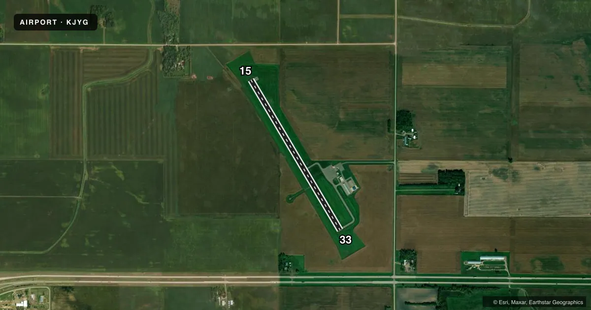
Runways & pattern
Full pagePattern entry · RWY 33
LEFT TRAFFICRunway end performance
| End | TORA | TODA | ASDA | LDA | VGSI | Approach lights | Obstruction |
|---|---|---|---|---|---|---|---|
| 15 | — | — | — | — | PAPI 4-box left(2.83°) | — | — |
| 33 | — | — | — | — | PAPI 4-box left(2.83°) | — | — |
Declared distances in feet. TORA = takeoff run available, TODA = takeoff distance, ASDA = accelerate-stop, LDA = landing distance.
Airport sketch
Runways drawn to scale from FAA survey coordinates, rendered over satellite imagery. Not for navigation.
Approaches & charts
Services on the field
Fuel grades, oxygen, maintenance, ramp storage and lighting — as declared to the FAA by the airport operator.
Fuel & services
- Fuel
- 100LL
- Oxygen (bottled)
- Not available
- Oxygen (bulk)
- Not available
- Airframe repair
- Not available
- Power plant repair
- Not available
Ramp & ground
- Transient storage
- Tie-down
- Lighting schedule
- SEE RMK
- Beacon schedule
- SS-SR
- Beacon
- White / Green (civil land)(WG)
- Wind indicator
- Lighted
- Segmented circle
- No
Fuel & FBOs
Cheapest 100LL and Jet A on the field and nearby. Always confirm with the FBO before taxi.
Airport notes
Surface conditions, obstructions, local procedures, lighting outages and other notes published with each FAA cycle.
General notes
- ULTRALIGHT ACT ON & INVOF ARPT.
- GCO AVBL ON FREQ 121.725 THRU MINNEAPOLIS ARTCC & FLT SVCS.
- RWY 33 RT OF CTR LINE FRM APP END -120 TO -183 FT CATTAILS IN PRIMARY SURFACE
- ARR/DEP BLDG ACES CODE FM RAMP: 1215#; ACES CODE FM PRKG LOT: 1215.
- FOR CD IF UNA VIA GCO CTC MINNEAPOLIS ARTCC AT 651-463-5588.
Lighting notes
- ACTVT REIL RWY 15 & 33; PAPI RWY 15 & 33; MIRL RWY 15/33 - CTAF.
Fuel notes
- 100LLFUEL AVBL H24 VIA CREDIT CARD.
Other notes
- 1FOR SER CALL 507-375-3121.
VFR map & nearby airports
VFR sectional. Tap any ICAO chip to open that airport.
Key facts · KJYG
Answer card- ICAO
- KJYG
- Name
- ST JAMES MUNI
- Location
- ST JAMES, MINNESOTA
- Elevation
- 1,067.7 ft MSL
- Traffic pattern altitude
- 2,067.7 ft MSL (1,000 AGL)
- Control tower
- Non-towered (use CTAF)
- Total runways
- 1
- Longest runway
- 15/33 · 3,999 ft
- Published ILS approaches
- 0
- Published frequencies
- 1
- Magnetic variation
- 1°
- Current flight rules
- VFR
- Current wind
- 330° at 7 kt
- Favored runway now
- RWY 33
ST JAMES MUNI sits in St James, Minnesota. The field elevation is 1,067.7 ft MSL. It has one runway. Runway 15/33 is 3,999 ft long with asphalt pavement. There is no control tower, so traffic works on CTAF 122.9. No ILS approaches are published here.
Published pattern altitude is not listed. Use the standard 1,000 ft AGL unless the current Chart Supplement says otherwise. That puts the light-aircraft pattern at about 2,067.7 ft MSL based on the field elevation, but verify before you fly. The airport has runway end identifier lights on 15 and 33. PAPI is installed on both ends. Medium intensity runway lights are on runway 15/33 and are controlled by CTAF.
St. James Municipal Airport is on the field and carries 100LL. Fuel is available 24 hours a day by credit card. Ultralight activity occurs on and near the airport, so keep a close scan in the pattern. Runway 33 has cattails right of centerline near the approach end, from 120 to 183 ft in the primary surface. The airport uses a ramp access code for the building. Check the current access code before arrival. If you need service, use the airport phone number in the Chart Supplement or call the FBO directly.