METAR & TAF KAXA
Current METAR
Observed 19:55Z
KAXA 271955Z AUTO 32010KT 10SM CLR 33/22 A2977 RMK A01
- Wind
- 320° @ 10 kt
- Visibility
- 10 SM
- Temp / Dew
- 33°C / 22°C
- Altimeter
- 29.77 inHg
- Clouds
- CLR
- Density alt
- 3,854 ft
- Ceiling
- Unlimited
- Rules
- VFR
Airport info & contacts
Manager on record, flight service, ARTCC, attendance schedule and pattern altitude — published by the FAA and refreshed every 28 days.
Location
- From city
- 2 NM W
- VFR sectional
- OMAHA
- ARTCC
- ZMP · MINNEAPOLIS
- NOTAM facility
- AXA (NOTAM-D)
Airport manager
- Name
- JIM KOHLHAAS
- Phone
- 515-295-7492
- Address
- 2907 HWY 18 W, ALGONA IA 50511
Flight service · Hours
- FSS FOD
- FORT DODGE1-800-WX-BRIEF
- Attendance
- MON-FRI · 0800-1700
- SAT · 0800-1200
Frequencies
Tap any row to copy the frequency to your clipboard.
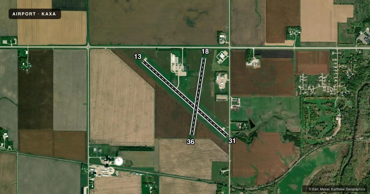
Runways & pattern
Full pagePattern entry · RWY 31
LEFT TRAFFIC| Runway | Heading (°M) | Length | Surface | Traffic |
|---|---|---|---|---|
| 13/31Favored | 129° / 309° | 4,200 ft | CONC | Standard L |
| 18/36 | 186° / 6° | 2,895 ft | TURF | Standard L |
Runway end performance
| End | TORA | TODA | ASDA | LDA | VGSI | Approach lights | Obstruction |
|---|---|---|---|---|---|---|---|
| 13 | — | — | — | — | PAPI 2-box left(3°) | — | 22', road, 500' from thr, 230' R of cntrln, slope 13 |
| 31 | — | — | — | — | PAPI 2-box left(3°) | — | — |
| 18 | — | — | — | — | — | — | 15', road, 340' from thr, 0' R of cntrln, slope 22 |
| 36 | — | — | — | — | — | — | 4', fence, 135' from thr, 0' R of cntrln, slope 33 |
Declared distances in feet. TORA = takeoff run available, TODA = takeoff distance, ASDA = accelerate-stop, LDA = landing distance.
Airport sketch
Runways drawn to scale from FAA survey coordinates, rendered over satellite imagery. Not for navigation.
Approaches & charts
Services on the field
Fuel grades, oxygen, maintenance, ramp storage and lighting — as declared to the FAA by the airport operator.
Fuel & services
- Fuel
- 100LLA
- Oxygen (bottled)
- Not available
- Oxygen (bulk)
- Not available
- Airframe repair
- Major
- Power plant repair
- Major
- Other services
- AGRI,CHTR,INSTR,RNTL
Ramp & ground
- Transient storage
- Tie-down
- Hangar
- Landing fee
- No fee published
- Customs
- Not available
- Lighting schedule
- SEE RMK
- Beacon schedule
- SS-SR
- Beacon
- White / Green (civil land)(WG)
- Wind indicator
- Lighted
- Segmented circle
- No
Fuel & FBOs
Cheapest 100LL and Jet A on the field and nearby. Always confirm with the FBO before taxi.
Airport notes
Surface conditions, obstructions, local procedures, lighting outages and other notes published with each FAA cycle.
General notes
- RWY 13 IS CALM WIND RWY.
- FOR CD CTC MINNEAPOLIS ARTCC AT 651-463-5588.
- RWY 18/36 NO SNOW REMOVAL, RWY CLSD WHEN SNOW CONDITIONS EXIST.
Lighting notes
- ACTVT MIRL RWY 13/31; REIL AND PAPI RWYS 13 & 31 - CTAF.
Approach & departure obstructions
- 364' FENCE 135' FROM RWY END
- 1331:1 CLEARANCE TO DTHR.
- 18RWY 18/36 MKD WITH YELLOW CONES.
VFR map & nearby airports
VFR sectional. Tap any ICAO chip to open that airport.
Key facts · KAXA
Answer card- ICAO
- KAXA
- Name
- ALGONA MUNI
- Location
- ALGONA, IOWA
- Elevation
- 1,216.1 ft MSL
- Traffic pattern altitude
- 2,216.1 ft MSL (1,000 AGL)
- Control tower
- Non-towered (use CTAF)
- Total runways
- 2
- Longest runway
- 13/31 · 4,200 ft
- Published ILS approaches
- 0
- Published frequencies
- 2
- Magnetic variation
- 3°
- Current flight rules
- VFR
- Current wind
- 320° at 10 kt
- Favored runway now
- RWY 31
Algona Muni sits in Algona, Iowa. Field elevation is 1,216.1 ft MSL. The airport has two runways. The longest is 13/31 at 4,200 ft of concrete. Runway 18/36 is 2,895 ft of turf. There is no control tower. CTAF and UNICOM are both 122.8. No ILS approaches are published here.
Pattern altitude is not published. Use the standard 1,000 ft AGL pattern unless local guidance says otherwise. That puts the light piston pattern at about 2,216 ft MSL based on the field elevation. For clearance delivery, Minneapolis ARTCC handles it. The published remarks also say runway 13 is the calm wind runway. Runway 13/31 has medium intensity lighting. REILs and PAPI are on 13 and 31. They are controlled by CTAF.
Algona Aero Service is on the field. It carries 100LL and Jet A Prist. Runway 18/36 has no snow removal. It is closed when snow conditions exist. Runway 18/36 is marked with yellow cones. There is also a 4-foot fence 135 feet from the runway end near runway 36. For a first-time arrival, the main things to plan for are the non-towered pattern. Plan for the turf runway limits in winter. The concrete runway is the better choice for most arrivals and departures.