METAR & TAF KEAG
KEAG does not publish a METAR.
Showing the nearest reporting station: KCAV (CLARION MUNI) · 7.2 NM away. Conditions at KEAG may differ.
METAR · KCAV
Observed 18:35Z
KCAV 271835Z AUTO 31008KT 10SM CLR 33/31 A2977 RMK A01
- Wind
- 310° @ 8 kt
- Visibility
- 10 SM
- Temp / Dew
- 33°C / 31°C
- Altimeter
- 29.77 inHg
- Clouds
- CLR
- Density alt
- 3,750 ft
- Ceiling
- Unlimited
- Rules
- VFR
Airport info & contacts
Manager on record, flight service, ARTCC, attendance schedule and pattern altitude — published by the FAA and refreshed every 28 days.
Location
- From city
- 3 NM N
- VFR sectional
- OMAHA
- ARTCC
- ZMP · MINNEAPOLIS
- NOTAM facility
- FOD (NOTAM-D)
Airport manager
- Name
- BRYCE DAVIS
- Phone
- 515-851-5826
- Address
- 2355 HWY 17, EAGLE GROVE IA 50533
Flight service · Hours
- FSS FOD
- FORT DODGE1-800-WX-BRIEF
- Attendance
- Unattended
Frequencies
Tap any row to copy the frequency to your clipboard.
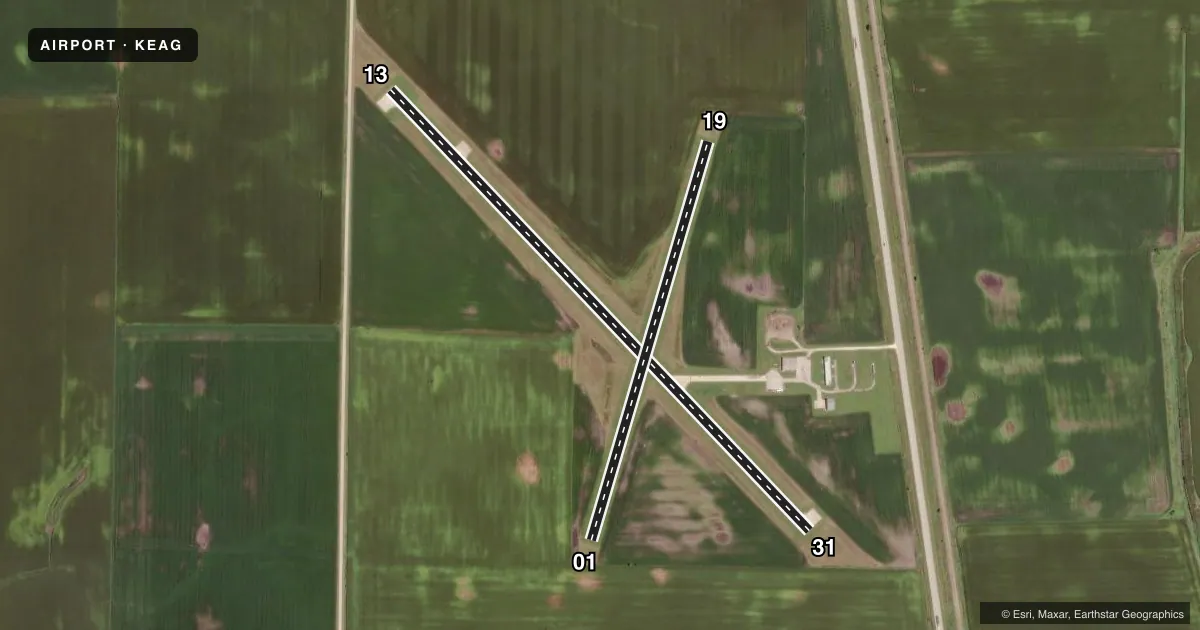
Runways & pattern
Full pagePattern entry · RWY 31
LEFT TRAFFIC| Runway | Heading (°M) | Length | Surface | Traffic |
|---|---|---|---|---|
| 13/31Favored | 133° / 313° | 3,500 ft | CONC | Standard L |
| 01/19 | 13° / 193° | 2,389 ft | TURF | Standard L |
Runway end performance
| End | TORA | TODA | ASDA | LDA | VGSI | Approach lights | Obstruction |
|---|---|---|---|---|---|---|---|
| 13 | — | — | — | — | — | — | 15', road, 200' from thr, 120' R of cntrln, slope 0 |
| 31 | — | — | — | — | — | — | 46', tree, 1429' from thr, 19' R of cntrln, slope 26 |
Declared distances in feet. TORA = takeoff run available, TODA = takeoff distance, ASDA = accelerate-stop, LDA = landing distance.
Airport sketch
Runways drawn to scale from FAA survey coordinates, rendered over satellite imagery. Not for navigation.
Approaches & charts
Services on the field
Fuel grades, oxygen, maintenance, ramp storage and lighting — as declared to the FAA by the airport operator.
Fuel & services
- Fuel
- 100LL
- Oxygen (bottled)
- Not available
- Oxygen (bulk)
- Not available
- Airframe repair
- Not available
- Power plant repair
- Not available
Ramp & ground
- Transient storage
- Tie-down
- Hangar
- Landing fee
- No fee published
- Customs
- Not available
- Lighting schedule
- SEE RMK
- Beacon schedule
- SS-SR
- Beacon
- White / Green (civil land)(WG)
- Wind indicator
- Lighted
- Segmented circle
- No
Fuel & FBOs
Cheapest 100LL and Jet A on the field and nearby. Always confirm with the FBO before taxi.
Airport notes
Surface conditions, obstructions, local procedures, lighting outages and other notes published with each FAA cycle.
General notes
- FOR CD CTC MINNEAPOLIS ARTCC AT 651-463-5588.
Lighting notes
- ACTVT MIRL RY 13/31 & REIL RYS 13 & 31 - CTAF.
Runway surface & condition
- 01/19CLSD NOV-APR.
Approach & departure obstructions
- 13+15 ROAD 184' FM THR 120' R.
- 13REIL OTS INDEFLY.
- 0101/19 MKD WITH YELLOW CONES.
- 13DSPLCD THR ALLOWS A 20:1 CLNC OVER ROAD.
Other notes
- ESTABD PRIOR TO 1959.
- OWNERDON GARRETT ARPT CMSN CHMN; PHONE 515-448-4073.
VFR map & nearby airports
VFR sectional. Tap any ICAO chip to open that airport.
Key facts · KEAG
Answer card- ICAO
- KEAG
- Name
- EAGLE GROVE MUNI
- Location
- EAGLE GROVE, IOWA
- Elevation
- 1,132.3 ft MSL
- Traffic pattern altitude
- 2,132.3 ft MSL (1,000 AGL)
- Control tower
- Non-towered (use CTAF)
- Total runways
- 2
- Longest runway
- 13/31 · 3,500 ft
- Published ILS approaches
- 0
- Published frequencies
- 2
- Magnetic variation
- 3°
- Current flight rules
- VFR
- Current wind
- 310° at 8 kt
- Favored runway now
- RWY 31
Eagle Grove Muni sits in Eagle Grove, Iowa. Field elevation is 1,132.3 ft MSL. The airport has two runways. The longest is runway 13/31 at 3,500 ft on concrete. Runway 01/19 is turf at 2,389 ft. There is no control tower. CTAF and UNICOM are both 122.8. No ILS approaches are published here.
Pattern altitude is not published. Use 2,132 ft MSL for a standard 1,000 ft AGL light piston pattern unless the current Chart Supplement says otherwise. Runway 13/31 has medium intensity lights. Runway end identifier lights are active on 13 and 31 on CTAF. The remarks also note that runway 13 has a displaced threshold for road clearance. There is a 15 ft road obstruction 184 ft from the threshold, 120 ft right. Runway 13 REILs are out of service indefinitely.
Runway 01/19 is closed from November through April. It is marked with yellow cones when open. There are no on-field FBOs listed. Contact the airport operator directly before arrival. For clearance delivery, contact Minneapolis ARTCC at 651-463-5588. First-time pilots should plan for a non-towered field. Verify runway status before departure. Brief the lighting and obstruction notes before a night or low-vis arrival.