METAR & TAF KCAV
Current METAR
Observed 17:15Z
KCAV 271715Z AUTO 33008KT 10SM FEW020 32/32 A2978 RMK A01
- Wind
- 330° @ 8 kt
- Visibility
- 10 SM
- Temp / Dew
- 32°C / 32°C
- Altimeter
- 29.78 inHg
- Clouds
- FEW
- Density alt
- 3,648 ft
- Ceiling
- Unlimited
- Rules
- VFR
Airport info & contacts
Manager on record, flight service, ARTCC, attendance schedule and pattern altitude — published by the FAA and refreshed every 28 days.
Location
- From city
- 1 NM NW
- VFR sectional
- OMAHA
- ARTCC
- ZMP · MINNEAPOLIS
- NOTAM facility
- CAV (NOTAM-D)
Airport manager
- Name
- JON DEVRIES
- Phone
- 515-532-6980
- Address
- 2076 - 210TH STREET, CLARION IA 50525
Flight service · Hours
- FSS FOD
- FORT DODGE1-800-WX-BRIEF
- Attendance
- Unattended
Frequencies
Tap any row to copy the frequency to your clipboard.
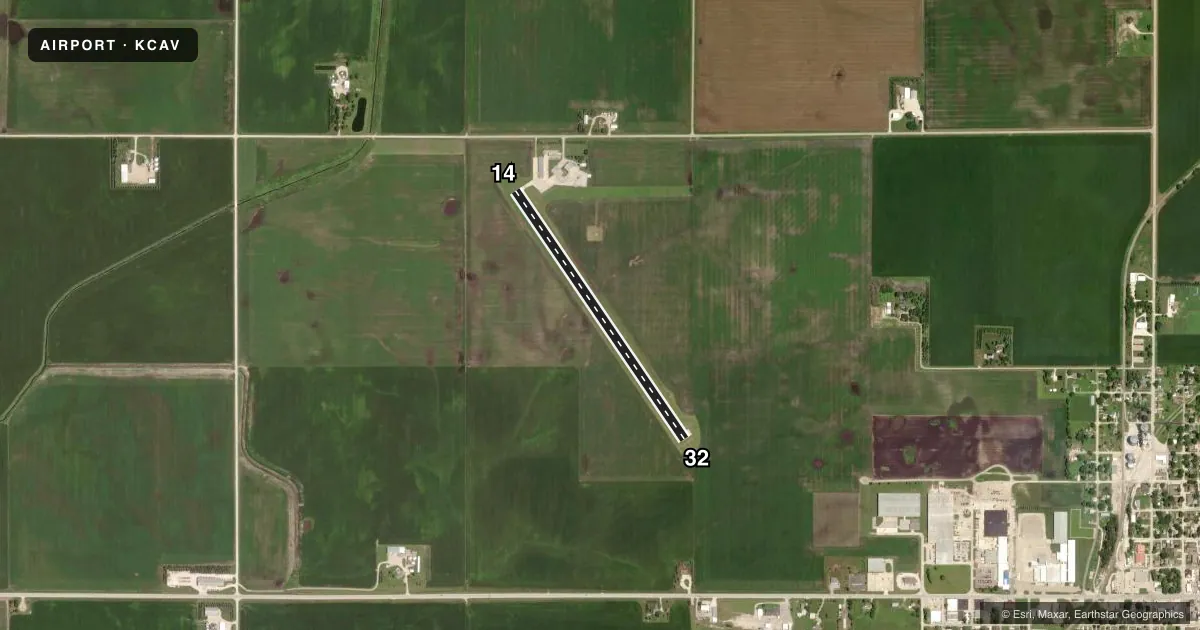
Runways & pattern
Full pagePattern entry · RWY 32
LEFT TRAFFICRunway end performance
| End | TORA | TODA | ASDA | LDA | VGSI | Approach lights | Obstruction |
|---|---|---|---|---|---|---|---|
| 14 | — | — | — | — | PAPI 2-box left(3°) | — | 18', road, 560' from thr, 280' R of cntrln, slope 20 |
| 32 | — | — | — | — | PAPI 2-box left(3°) | — | 59', pole, 2210' from thr, 0' R of cntrln, slope 34 |
Declared distances in feet. TORA = takeoff run available, TODA = takeoff distance, ASDA = accelerate-stop, LDA = landing distance.
Airport sketch
Runways drawn to scale from FAA survey coordinates, rendered over satellite imagery. Not for navigation.
Approaches & charts
Services on the field
Fuel grades, oxygen, maintenance, ramp storage and lighting — as declared to the FAA by the airport operator.
Fuel & services
- Fuel
- 100LLA
- Oxygen (bottled)
- Not available
- Oxygen (bulk)
- Not available
- Airframe repair
- Not available
- Power plant repair
- Not available
Ramp & ground
- Transient storage
- Tie-down
- Hangar
- Landing fee
- No fee published
- Customs
- Not available
- Lighting schedule
- SEE RMK
- Beacon schedule
- SS-SR
- Beacon
- White / Green (civil land)(WG)
- Wind indicator
- Lighted
- Segmented circle
- No
Fuel & FBOs
Cheapest 100LL and Jet A on the field and nearby. Always confirm with the FBO before taxi.
Airport notes
Surface conditions, obstructions, local procedures, lighting outages and other notes published with each FAA cycle.
General notes
- FOR CD CTC MINNEAPOLIS ARTCC AT 651-463-5588.
Lighting notes
- RY 14/32 MIRL PRESET LOW INTST; ACTVT PAPI & REIL RY 14 & 32 & MIRL RY 14/32 HIGHER INTST - CTAF
VFR map & nearby airports
VFR sectional. Tap any ICAO chip to open that airport.
Key facts · KCAV
Answer card- ICAO
- KCAV
- Name
- CLARION MUNI
- Location
- CLARION, IOWA
- Elevation
- 1,156.6 ft MSL
- Traffic pattern altitude
- 2,156.6 ft MSL (1,000 AGL)
- Control tower
- Non-towered (use CTAF)
- Total runways
- 1
- Longest runway
- 14/32 · 3,455 ft
- Published ILS approaches
- 0
- Published frequencies
- 2
- Magnetic variation
- 3°
- Current flight rules
- VFR
- Current wind
- 330° at 8 kt
- Favored runway now
- RWY 32
Clarion Muni sits in Clarion, Iowa. The field elevation is 1,156.6 ft MSL. It has one runway. Runway 14/32 is 3,455 ft long with a concrete surface. This is an uncontrolled airport with no control tower. CTAF and UNICOM are both 122.8.
No ILS approaches are published here. The pattern altitude is not published in the facts, so use the current Chart Supplement before you fly. For clearance delivery, the published remark points pilots to Minneapolis ARTCC at 651-463-5588. That is useful to have ready if you are filing or need a clearance.
The runway lighting note matters here. Runway 14/32 has medium intensity runway lights preset to low intensity. The PAPI and REIL on runways 14 and 32 can be activated by CTAF. The same CTAF activation also increases the runway light intensity. That is worth checking before a night arrival.
There are no on-field FBOs listed in the facts. Contact the airport operator directly before arrival, or call the field on CTAF or UNICOM for current service availability. With one runway and no published ILS, plan for a straightforward VFR or non-precision arrival. Check the current Chart Supplement for any local procedures before you go.