METAR & TAF KFXY
Current METAR
Observed 18:15Z
KFXY 271815Z AUTO 31010KT 260V320 10SM CLR 32/19 A2977 RMK AO2
- Wind
- 310° @ 10 kt
- Visibility
- 10 SM
- Temp / Dew
- 32°C / 19°C
- Altimeter
- 29.77 inHg
- Clouds
- CLR
- Density alt
- 3,750 ft
- Ceiling
- Unlimited
- Rules
- VFR
Airport info & contacts
Manager on record, flight service, ARTCC, attendance schedule and pattern altitude — published by the FAA and refreshed every 28 days.
Location
- From city
- 2 NM S
- VFR sectional
- OMAHA
- ARTCC
- ZMP · MINNEAPOLIS
- NOTAM facility
- FOD (NOTAM-D)
Airport manager
- Name
- R. TRIMBLE
- Phone
- 641-581-2880
- Address
- MUNICIPAL ARPT, 1842 330TH ST, FOREST CITY IA 50436
Flight service · Hours
- FSS FOD
- FORT DODGE1-800-WX-BRIEF
- Attendance
- MON-FRI · 0800-1730
Frequencies
Tap any row to copy the frequency to your clipboard.
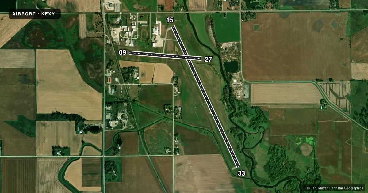
Runways & pattern
Full pagePattern entry · RWY 33
LEFT TRAFFIC| Runway | Heading (°M) | Length | Surface | Traffic |
|---|---|---|---|---|
| 15/33Favored | 152° / 332° | 5,796 ft | ASPH | Standard L |
| 09/27 | 92° / 272° | 2,707 ft | ASPH | Standard L |
Runway end performance
| End | TORA | TODA | ASDA | LDA | VGSI | Approach lights | Obstruction |
|---|---|---|---|---|---|---|---|
| 15 | — | — | — | — | PAPI 2-box left(3°) | — | 39', trees, 750' from thr, 10' R of cntrln, slope 14 |
| 33 | — | — | — | — | PAPI 2-box left(3°) | — | 5', fence, 315' from thr, 0' R of cntrln, slope 28 |
| 09 | — | — | — | — | — | — | 34', tree, 645' from thr, 121' R of cntrln, slope 13 |
| 27 | — | — | — | — | — | — | 11', tree, 231' from thr, 49' R of cntrln, slope 2 |
Declared distances in feet. TORA = takeoff run available, TODA = takeoff distance, ASDA = accelerate-stop, LDA = landing distance.
Airport sketch
Runways drawn to scale from FAA survey coordinates, rendered over satellite imagery. Not for navigation.
Approaches & charts
Services on the field
Fuel grades, oxygen, maintenance, ramp storage and lighting — as declared to the FAA by the airport operator.
Fuel & services
- Fuel
- 100LL
- Oxygen (bottled)
- Not available
- Oxygen (bulk)
- Not available
- Airframe repair
- Major
- Power plant repair
- Major
- Other services
- INSTR,RNTL,SALES
Ramp & ground
- Transient storage
- Tie-down
- Landing fee
- No fee published
- Customs
- Not available
- Lighting schedule
- SEE RMK
- Beacon schedule
- SS-SR
- Beacon
- White / Green (civil land)(WG)
- Wind indicator
- Lighted
- Segmented circle
- No
Fuel & FBOs
Cheapest 100LL and Jet A on the field and nearby. Always confirm with the FBO before taxi.
Airport notes
Surface conditions, obstructions, local procedures, lighting outages and other notes published with each FAA cycle.
General notes
- FOR CD CTC MINNEAPOLIS ARTCC AT 651-463-5588.
Lighting notes
- ACTVT REIL RWY 15 & 33; PAPI RWY 15 & 33; MIRL RWY 09/27 & 15/33 - CTAF.
Approach & departure obstructions
- 1534:1 TO DTHR.
Other notes
- 1AFT HR - 641-590-2127 OR AMGR.
- MANAGER641-585-2166.
VFR map & nearby airports
VFR sectional. Tap any ICAO chip to open that airport.
Key facts · KFXY
Answer card- ICAO
- KFXY
- Name
- FOREST CITY MUNI/TRIMBLE FLD
- Location
- FOREST CITY, IOWA
- Elevation
- 1,229.2 ft MSL
- Traffic pattern altitude
- 2,229.2 ft MSL (1,000 AGL)
- Control tower
- Non-towered (use CTAF)
- Total runways
- 2
- Longest runway
- 15/33 · 5,796 ft
- Published ILS approaches
- 0
- Published frequencies
- 2
- Magnetic variation
- 3°
- Current flight rules
- VFR
- Current wind
- 310° at 10 kt
- Favored runway now
- RWY 33
Forest City Muni/Trimble Fld is in Forest City, Iowa. Field elevation is 1,229.2 ft MSL. The airport has two asphalt runways. The longest is runway 15/33 at 5,796 ft. Runway 09/27 is 2,707 ft.
This is a non-towered field. Use CTAF 122.8 for traffic calls. No ILS approaches are published. The published pattern altitude is not listed, so a light piston pilot should plan on the standard 1,000 ft AGL pattern unless the current Chart Supplement says otherwise. Runway 15 and 33 have REIL and PAPI. Both runways 09/27 and 15/33 have medium intensity runway lighting.
Forest City Aviation is on the field. It carries 100LL and Jet A Prist. The airport manager can be reached at 641-585-2166. After hours, the published contact is 641-590-2127 or the airport manager. One operational item to keep in mind is the displaced threshold on runway 15. The published remarks note a 34 to 1 slope to that threshold. For IFR clearances, contact Minneapolis ARTCC at 651-463-5588. Check the current Chart Supplement before departure for any updated remarks or local procedures.