METAR & TAF KEST
Current METAR
Observed 16:49Z
KEST 271649Z AUTO 36006KT 10SM CLR 29/22 A2981 RMK AO2 SLP081 T02890222
- Wind
- 360° @ 6 kt
- Visibility
- 10 SM
- Temp / Dew
- 29°C / 22°C
- Altimeter
- 29.81 inHg
- Clouds
- CLR
- Density alt
- 3,452 ft
- Ceiling
- Unlimited
- Rules
- VFR
Airport info & contacts
Manager on record, flight service, ARTCC, attendance schedule and pattern altitude — published by the FAA and refreshed every 28 days.
Location
- From city
- 4 NM E
- VFR sectional
- OMAHA
- ARTCC
- ZMP · MINNEAPOLIS
- NOTAM facility
- EST (NOTAM-D)
Airport manager
- Name
- MATT MCNAE
- Phone
- 712-362-2761
- Address
- 1672 425TH AVENUE, ESTHERVILLE IA 51334
Flight service · Hours
- FSS FOD
- FORT DODGE1-800-WX-BRIEF
- Attendance
- DAWN-DUSK
Frequencies
Tap any row to copy the frequency to your clipboard.
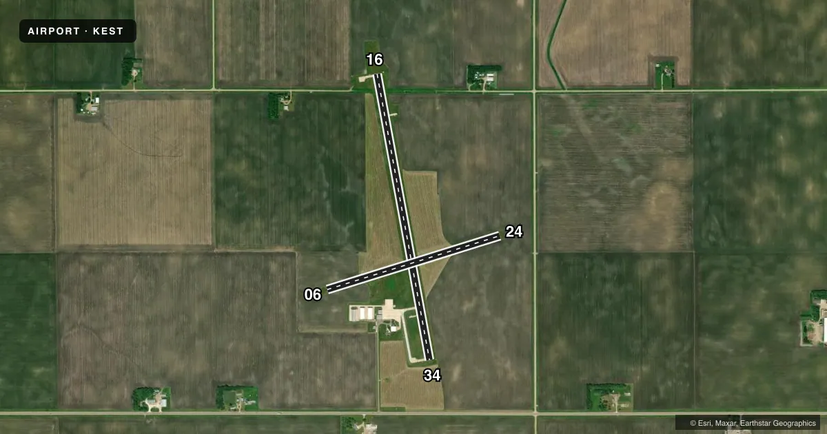
Runways & pattern
Full pagePattern entry · RWY 34
LEFT TRAFFIC| Runway | Heading (°M) | Length | Surface | Traffic |
|---|---|---|---|---|
| 16/34Favored | 169° / 349° | 4,797 ft | CONC | Standard L |
| 06/24 | 72° / 252° | 2,989 ft | TURF | Standard L |
Runway end performance
| End | TORA | TODA | ASDA | LDA | VGSI | Approach lights | Obstruction |
|---|---|---|---|---|---|---|---|
| 16 | — | — | — | — | PAPI 4-box left(3°) | — | — |
| 34 | — | — | — | — | PAPI 4-box left(3°) | — | 19', road, 850' from thr, 0' R of cntrln, slope 34 |
| 24 | — | — | — | — | — | — | 15', road, 575' from thr, 0' R of cntrln, slope 38 |
Declared distances in feet. TORA = takeoff run available, TODA = takeoff distance, ASDA = accelerate-stop, LDA = landing distance.
Airport sketch
Runways drawn to scale from FAA survey coordinates, rendered over satellite imagery. Not for navigation.
Approaches & charts
Services on the field
Fuel grades, oxygen, maintenance, ramp storage and lighting — as declared to the FAA by the airport operator.
Fuel & services
- Fuel
- 100LLA+
- Oxygen (bottled)
- Not available
- Oxygen (bulk)
- Not available
- Airframe repair
- Major
- Power plant repair
- Major
- Other services
- CHTR,INSTR,RNTL,SALES
Ramp & ground
- Transient storage
- Not published
- Landing fee
- No fee published
- Customs
- Not available
- Lighting schedule
- SEE RMK
- Beacon schedule
- SS-SR
- Beacon
- White / Green (civil land)(WG)
- Wind indicator
- Lighted
- Segmented circle
- No
Fuel & FBOs
Cheapest 100LL and Jet A on the field and nearby. Always confirm with the FBO before taxi.
Airport notes
Surface conditions, obstructions, local procedures, lighting outages and other notes published with each FAA cycle.
General notes
- RY 34 IS CALM WIND RY.
- FOR CD CTC MINNEAPOLIS ARTCC AT 651-463-5588.
Lighting notes
- ACTVT MIRL RY 16/34; REIL RYS 16 & 34; PAPI RYS 16 & 34 - CTAF.
Approach & departure obstructions
- 16REIL ARE OMNIDIRECTIONAL.
- 0606/24 MARKED WITH YELLOW CONES.
Other notes
- 1FOR SERVICE AFTER HRS CALL 712-362-2761.
- MANAGERIOWA LAKES AVIATION
VFR map & nearby airports
VFR sectional. Tap any ICAO chip to open that airport.
Key facts · KEST
Answer card- ICAO
- KEST
- Name
- ESTHERVILLE MUNI
- Location
- ESTHERVILLE, IOWA
- Elevation
- 1,318.8 ft MSL
- Traffic pattern altitude
- 2,318.8 ft MSL (1,000 AGL)
- Control tower
- Non-towered (use CTAF)
- Total runways
- 2
- Longest runway
- 16/34 · 4,797 ft
- Published ILS approaches
- 0
- Published frequencies
- 2
- Magnetic variation
- 1°
- Current flight rules
- VFR
- Current wind
- 360° at 6 kt
- Favored runway now
- RWY 34
Estherville Muni is in Estherville, Iowa. Field elevation is 1,318.8 ft MSL. The airport has two runways. The longest is runway 16/34 at 4,797 ft. Runway 06/24 is 2,989 ft and turf. There is no control tower. CTAF and UNICOM are both 122.975.
No ILS approaches are published here. Pattern altitude is not published, so plan on the standard 1,000 ft AGL for light piston traffic unless the current Chart Supplement says otherwise. Runway 34 is the calm wind runway. Runway 06/24 is marked with yellow cones. Runway 16/34 has medium intensity lights. REILs are installed on 16 and 34. PAPI is also installed on 16 and 34 and is controlled on CTAF.
Estherville Aviation is on the field. It carries 100LL and Jet A Prist. For service after hours, call the number in the Chart Supplement or the FBO directly. If you need clearance delivery, Minneapolis ARTCC is listed in the remarks. This is a non-towered field with a paved primary runway and a turf secondary runway, so brief the surface choice before arrival. Check the current Chart Supplement for any noise or curfew restrictions before flying in.