METAR & TAF 0F3
0F3 does not publish a METAR.
Showing the nearest reporting station: KSPW (SPENCER MUNI) · 13.6 NM away. Conditions at 0F3 may differ.
METAR · KSPW
Observed 18:53Z
KSPW 271853Z AUTO 35008KT 10SM CLR 33/18 A2981 RMK AO2 SLP082 T03330183
- Wind
- 350° @ 8 kt
- Visibility
- 10 SM
- Temp / Dew
- 33°C / 18°C
- Altimeter
- 29.81 inHg
- Clouds
- CLR
- Density alt
- 4,075 ft
- Ceiling
- Unlimited
- Rules
- VFR
Airport info & contacts
Manager on record, flight service, ARTCC, attendance schedule and pattern altitude — published by the FAA and refreshed every 28 days.
Location
- From city
- 3 NM SW
- VFR sectional
- OMAHA
- ARTCC
- ZMP · MINNEAPOLIS
- NOTAM facility
- FOD (NOTAM-D)
Airport manager
- Name
- DICKINSON COUNTY ARPT AUTH
- Phone
- 712-332-9412
- Address
- BOX 702, OKOBOJI IA 51355
Flight service · Hours
- FSS FOD
- FORT DODGE1-800-WX-BRIEF
- Attendance
- MAY-SEP · IRREG
Frequencies
Tap any row to copy the frequency to your clipboard.
Runways & pattern
Full pagePattern entry · RWY 34
LEFT TRAFFICRunway end performance
| End | TORA | TODA | ASDA | LDA | VGSI | Approach lights | Obstruction |
|---|---|---|---|---|---|---|---|
| 16 | — | — | — | — | — | — | 10', gnd, 520' from thr, slope 32 |
| 34 | — | — | — | — | — | — | 58', tree, 243' from thr, 128' R of cntrln, slope 0 |
Declared distances in feet. TORA = takeoff run available, TODA = takeoff distance, ASDA = accelerate-stop, LDA = landing distance.
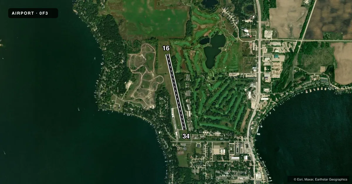
Airport sketch
Runways drawn to scale from FAA survey coordinates, rendered over satellite imagery. Not for navigation.
Approaches & charts
Services on the field
Fuel grades, oxygen, maintenance, ramp storage and lighting — as declared to the FAA by the airport operator.
Fuel & services
- Fuel
- Not available
- Oxygen (bottled)
- Not available
- Oxygen (bulk)
- Not available
Ramp & ground
- Transient storage
- Tie-down
- Hangar
- Landing fee
- No fee published
- Lighting schedule
- SEE RMK
- Wind indicator
- Lighted
- Segmented circle
- No
Fuel & FBOs
Cheapest 100LL and Jet A on the field and nearby. Always confirm with the FBO before taxi.
Airport notes
Surface conditions, obstructions, local procedures, lighting outages and other notes published with each FAA cycle.
General notes
- TALL WTR TANK AT 1635 FT MSL LCTD APRX 1830 FT ABM AND WEST OF RWY 16/34. EXER CTN WHILE IN ARPT TFC PAT.
- FOR CD CTC MINNEAPOLIS ARTCC AT 651-463-5588.
- CAUTION FOR WILDLIFE IN THE AREA
Lighting notes
- DUSK-DAWN. ACTVT REIL RWY 16 - CTAF.
Approach & departure obstructions
- 1610 FT TREES AND BRUSH 0 FT FM RWY END 110 FT L ON APCH 0:0 APCH SLP.
- 3425 FT TREES AND BRUSH 0 FT FM RWY END 105 FT R ON APCH 0:0 APCH SLP.
- 16+30' TREES 100' RIGHT OF RWY CNTRLN EXTNDD 520' FROM AER.
- 16CONTROLLING OBST EXCEEDS A 45 DEG SLP.
Other notes
- BASED ACFT 40 SEASONALLY MAY-SEP.
- MANAGERBRUCE SMITH
- OWNERARPT AUTHORITY CHAIRMAN - BRUCE SMITH - 712-332-7323.
VFR map & nearby airports
VFR sectional. Tap any ICAO chip to open that airport.
Key facts · 0F3
Answer card- ICAO
- 0F3
- Name
- SPIRIT LAKE MUNI
- Location
- SPIRIT LAKE, IOWA
- Elevation
- 1,434 ft MSL
- Traffic pattern altitude
- 2,434 ft MSL (1,000 AGL)
- Control tower
- Non-towered (use CTAF)
- Total runways
- 1
- Longest runway
- 16/34 · 3,015 ft
- Published ILS approaches
- 0
- Published frequencies
- 2
- Magnetic variation
- 5°
- Current flight rules
- VFR
- Current wind
- 350° at 8 kt
- Favored runway now
- RWY 34
Spirit Lake Muni sits in Spirit Lake, Iowa. Field elevation is 1,434 ft MSL. The airport has one runway. Runway 16/34 is 3,015 ft long with an asphalt surface. There is no control tower. CTAF and UNICOM are both 122.7. No ILS approaches are published here.
Pattern altitude is not published. For light piston traffic, use the standard 1,000 ft AGL pattern unless the current Chart Supplement or local procedures say otherwise. That puts the pattern at about 2,434 ft MSL based on field elevation. Check the current Chart Supplement before flight for any published noise or curfew restrictions.
Published remarks call out a few items that matter on arrival. There is a tall water tank west of runway 16/34. Trees and brush are close to both runway ends. The runway 34 end also has trees and brush near the approach path. Wildlife caution is published too. Runway end identifier lights on runway 16 activate from dusk to dawn through the CTAF. No on-field FBOs are listed, so verify fuel and services with the airport operator or the field directly before you go. Clearance delivery is handled through Minneapolis ARTCC at 651-463-5588.