METAR & TAF KDVP
Current METAR
Observed 20:33Z
KDVP 272033Z AUTO 32007KT 10SM CLR 32/21 A2984 RMK AO2 T03230214
- Wind
- 320° @ 7 kt
- Visibility
- 10 SM
- Temp / Dew
- 32°C / 21°C
- Altimeter
- 29.84 inHg
- Clouds
- CLR
- Density alt
- 4,152 ft
- Ceiling
- Unlimited
- Rules
- VFR
Airport info & contacts
Manager on record, flight service, ARTCC, attendance schedule and pattern altitude — published by the FAA and refreshed every 28 days.
Location
- From city
- 1 NM W
- VFR sectional
- OMAHA
- ARTCC
- ZMP · MINNEAPOLIS
- NOTAM facility
- DVP (NOTAM-D)
Airport manager
- Name
- JOSH MALCHOW
- Phone
- 507-836-8534
- Address
- 2424 26TH ST, SLAYTON MN 56172-1244
Flight service · Hours
- FSS PNM
- PRINCETON1-800-WX-BRIEF
- Attendance
- Unattended
Frequencies
Tap any row to copy the frequency to your clipboard.
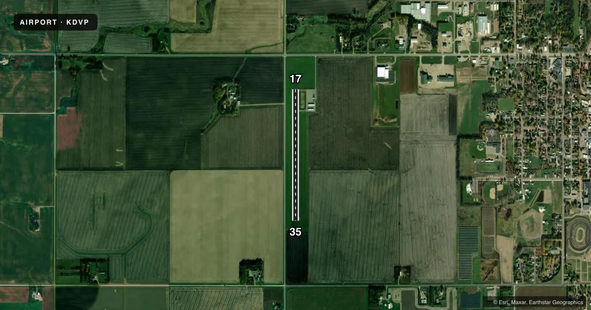
Runways & pattern
Full pagePattern entry · RWY 35
LEFT TRAFFICRunway end performance
| End | TORA | TODA | ASDA | LDA | VGSI | Approach lights | Obstruction |
|---|---|---|---|---|---|---|---|
| 17 | — | — | — | — | PAPI 2-box left(3°) | — | 15', road, 201' from thr, 235' R of cntrln, slope 0 |
| 35 | — | — | — | — | PAPI 2-box left(3°) | — | 15', road, 201' from thr, 235' R of cntrln, slope 0 |
Declared distances in feet. TORA = takeoff run available, TODA = takeoff distance, ASDA = accelerate-stop, LDA = landing distance.
Airport sketch
Runways drawn to scale from FAA survey coordinates, rendered over satellite imagery. Not for navigation.
Approaches & charts
Services on the field
Fuel grades, oxygen, maintenance, ramp storage and lighting — as declared to the FAA by the airport operator.
Fuel & services
- Fuel
- 100LL
- Oxygen (bottled)
- Not available
- Oxygen (bulk)
- Not available
- Airframe repair
- Not available
- Power plant repair
- Not available
- Other services
- AGRI,SALES
Ramp & ground
- Transient storage
- Tie-down
- Landing fee
- No fee published
- Lighting schedule
- SEE RMK
- Beacon schedule
- SS-SR
- Beacon
- White / Green (civil land)(WG)
- Wind indicator
- Lighted
- Segmented circle
- No
Fuel & FBOs
Cheapest 100LL and Jet A on the field and nearby. Always confirm with the FBO before taxi.
Airport notes
Surface conditions, obstructions, local procedures, lighting outages and other notes published with each FAA cycle.
General notes
- FOR CD CTC MINNEAPOLIS ARTCC AT 651-463-5588.
Lighting notes
- ACTVT REIL RWY 17 & 35; PAPI RWY 17 & 35; MIRL RWY 17/35 - CTAF.
Approach & departure obstructions
- 17+15 FT ROAD, 0-200 FT DIST, 235 FT R.
- 35+15 FT ROAD, 0-200 FT DIST, 235 FT L.
- 17+44 FT TREES, 1356 FT DIST, 0 FT B, 26:1.
- 35+30 FT PLINE, 1400 FT DIST, 0 FT B, 34:1.
Other notes
- 1FOR SVC CALL 507-836-6460.
VFR map & nearby airports
VFR sectional. Tap any ICAO chip to open that airport.
Key facts · KDVP
Answer card- ICAO
- KDVP
- Name
- SLAYTON MUNI
- Location
- SLAYTON, MINNESOTA
- Elevation
- 1,623 ft MSL
- Traffic pattern altitude
- 2,623 ft MSL (1,000 AGL)
- Control tower
- Non-towered (use CTAF)
- Total runways
- 1
- Longest runway
- 17/35 · 3,005 ft
- Published ILS approaches
- 0
- Published frequencies
- 1
- Magnetic variation
- 4°
- Current flight rules
- VFR
- Current wind
- 320° at 7 kt
- Favored runway now
- RWY 35
Slayton Muni is in Slayton, Minnesota. The field elevation is 1,623 ft MSL. It has one runway, 17/35, which is 3,005 ft long with an asphalt surface. There is no control tower. Use CTAF 122.9 for local traffic calls.
No ILS approaches are published here. The pattern altitude is not published, so use the current FAA Chart Supplement before you fly in. The airport has runway end identifier lights, PAPI on both ends and medium intensity runway lights on 17/35. Those lights are useful if you are planning a night arrival.
The on-field FBO is Slayton Municipal Airport. It carries AVGAS 100LL. For service, call the airport at (507) 836-8534. A separate remark lists (507) 836-6460 for service contact as well. Verify the current number before departure. Published remarks also call out obstacles near both ends of the runway. That means you should pay close attention on short final and during departure, especially on runway 17 and runway 35. Clearance delivery is handled through Minneapolis ARTCC at 651-463-5588. For any current noise, access, or operational guidance, check the current FAA Chart Supplement or call the airport operator directly.