METAR & TAF 3A9
3A9 does not publish a METAR.
Showing the nearest reporting station: KBKX (BROOKINGS RGNL) · 14.1 NM away. Conditions at 3A9 may differ.
METAR · KBKX
Observed 11:56Z
KBKX 271156Z AUTO 01006KT 10SM FEW002 22/22 A2983 RMK AO2 SLP096 T02220217 10261 20222 53007
- Wind
- 010° @ 6 kt
- Visibility
- 10 SM
- Temp / Dew
- 22°C / 22°C
- Altimeter
- 29.83 inHg
- Clouds
- FEW
- Density alt
- 3,206 ft
- Ceiling
- Unlimited
- Rules
- VFR
Airport info & contacts
Manager on record, flight service, ARTCC, attendance schedule and pattern altitude — published by the FAA and refreshed every 28 days.
Location
- From city
- 2 NM N
- VFR sectional
- OMAHA
- ARTCC
- ZMP · MINNEAPOLIS
- NOTAM facility
- HON (NOTAM-D)
Airport manager
- Name
- MARSHAL MIX
- Phone
- (605) 983-5251
- Address
- CITY OF ARLINGTON, PO BOX 379, ARLINGTON SD 57212
Flight service · Hours
- FSS HON
- HURON1-800-WX-BRIEF
- Attendance
- Unattended
Frequencies
Tap any row to copy the frequency to your clipboard.
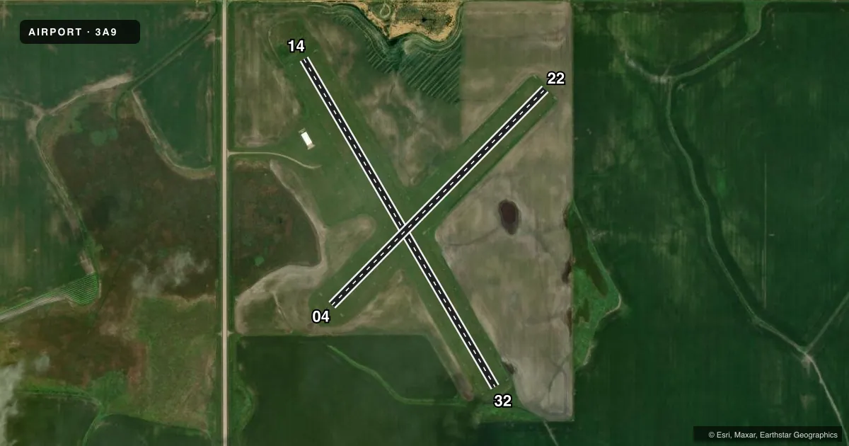
Runways & pattern
Full pagePattern entry · RWY 04
LEFT TRAFFICAirport sketch
Runways drawn to scale from FAA survey coordinates, rendered over satellite imagery. Not for navigation.
Approaches & charts
Services on the field
Fuel grades, oxygen, maintenance, ramp storage and lighting — as declared to the FAA by the airport operator.
Fuel & services
- Fuel
- Not available
- Oxygen (bottled)
- Not available
- Oxygen (bulk)
- Not available
- Airframe repair
- Not available
- Power plant repair
- Not available
- Other services
- GLD,TOW
Ramp & ground
- Transient storage
- Tie-down
- Landing fee
- No fee published
- Customs
- Not available
- Lighting schedule
- SS-SR
- Beacon schedule
- SS-SR
- Beacon
- White / Green (civil land)(WG)
- Wind indicator
- Lighted
- Segmented circle
- No
Fuel & FBOs
Cheapest 100LL and Jet A on the field and nearby. Always confirm with the FBO before taxi.
Airport notes
Surface conditions, obstructions, local procedures, lighting outages and other notes published with each FAA cycle.
General notes
- CULTIVATED FIELDS ALL QUADRANTS AT VARIOUS DSTCS FM RYS.
- ARPT CLSD 1 NOV TO 1 APR.
- WATERFOWL ON AND INVOF ARPT.
- FOR CD CTC MINNEAPOLIS ARTCC AT 651-463-5588.
Approach & departure obstructions
- 04RWY 04/22 MKD WITH WHITE/BLACK TIPPED MKR CONES.
- 14RWY 14/32 MKD WITH WHITE/BLACK TIPPED MKR CONES.
VFR map & nearby airports
VFR sectional. Tap any ICAO chip to open that airport.
Key facts · 3A9
Answer card- ICAO
- 3A9
- Name
- ARLINGTON MUNI
- Location
- ARLINGTON, SOUTH DAKOTA
- Elevation
- 1,818 ft MSL
- Traffic pattern altitude
- 2,818 ft MSL (1,000 AGL)
- Control tower
- Non-towered (use CTAF)
- Total runways
- 2
- Longest runway
- 14/32 · 3,000 ft
- Published ILS approaches
- 0
- Published frequencies
- 1
- Magnetic variation
- 6°
- Current flight rules
- VFR
- Current wind
- 010° at 6 kt
- Favored runway now
- RWY 04
Arlington Muni is in Arlington, South Dakota. The field elevation is 1,818 ft MSL. It has two turf runways. The longest is Runway 14/32 at 3,000 ft. The airport is not towered. CTAF is 122.9. No ILS approaches are published.
Pattern altitude is not published. Use 1,000 ft AGL for light piston operations unless the current Chart Supplement says otherwise. The airport is closed from November 1 to April 1, so plan around that seasonal closure before you launch. Cultivated fields sit in all quadrants. Waterfowl are reported on and near the airport, so expect bird activity in the pattern and on rollout. Both runways are marked with white and black tipped marker cones. There are no on-field FBOs listed. Verify services with the airport operator before arrival. For clearance delivery, contact Minneapolis ARTCC at 651-463-5588. This is a turf field with a short runway environment. Check surface condition. Check winds. Check braking before you commit.