METAR & TAF 8D9
8D9 does not publish a METAR.
Showing the nearest reporting station: KMDS (MADISON MUNI) · 19.4 NM away. Conditions at 8D9 may differ.
METAR · KMDS
Observed 07:35Z
KMDS 270735Z AUTO 36004KT 3SM BR CLR 24/24 A2979 RMK AO2 TSNO
- Wind
- 360° @ 4 kt
- Visibility
- 3 SM
- Temp / Dew
- 24°C / 24°C
- Altimeter
- 29.79 inHg
- Clouds
- CLR
- Density alt
- 3,208 ft
- Ceiling
- Unlimited
- Rules
- MVFR
Airport info & contacts
Manager on record, flight service, ARTCC, attendance schedule and pattern altitude — published by the FAA and refreshed every 28 days.
Location
- From city
- 1 NM N
- VFR sectional
- OMAHA
- ARTCC
- ZMP · MINNEAPOLIS
- NOTAM facility
- HON (NOTAM-D)
Airport manager
- Name
- CITY OF HOWARD
- Phone
- 605-772-4391
- Address
- PO BOX 145, HOWARD SD 57349
Flight service · Hours
- FSS HON
- HURON1-800-WX-BRIEF
- Attendance
- Unattended
Frequencies
Tap any row to copy the frequency to your clipboard.
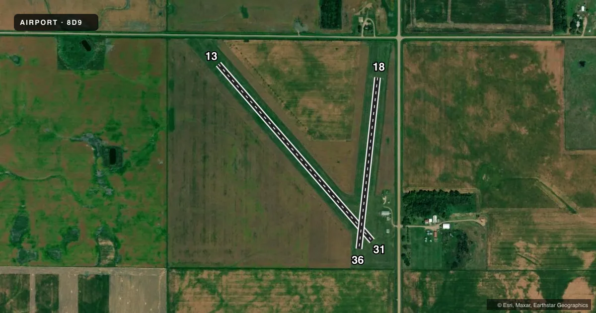
Runways & pattern
Full pagePattern entry · RWY 36
LEFT TRAFFIC| Runway | Heading (°M) | Length | Surface | Traffic |
|---|---|---|---|---|
| 13/31 | 132° / 312° | 2,656 ft | TURF | Standard L |
| 18/36Favored | 179° / 359° | 1,952 ft | TURF | Standard L |
Runway end performance
| End | TORA | TODA | ASDA | LDA | VGSI | Approach lights | Obstruction |
|---|---|---|---|---|---|---|---|
| 13 | — | — | — | — | — | — | 14', road, 300' from thr, 0' R of cntrln, slope 21 |
| 18 | — | — | — | — | — | — | 40', trees, 528' from thr, 153' R of cntrln, slope 13 |
| 36 | — | — | — | — | — | — | 4', fence, 80' from thr, 0' R of cntrln, slope 20 |
Declared distances in feet. TORA = takeoff run available, TODA = takeoff distance, ASDA = accelerate-stop, LDA = landing distance.
Airport sketch
Runways drawn to scale from FAA survey coordinates, rendered over satellite imagery. Not for navigation.
Approaches & charts
Services on the field
Fuel grades, oxygen, maintenance, ramp storage and lighting — as declared to the FAA by the airport operator.
Fuel & services
- Fuel
- Not available
- Oxygen (bottled)
- Not available
- Oxygen (bulk)
- Not available
- Airframe repair
- Not available
- Power plant repair
- Not available
- Other services
- AGRI
Ramp & ground
- Transient storage
- Tie-down
- Landing fee
- No fee published
- Customs
- Not available
- Wind indicator
- Yes
- Segmented circle
- No
Fuel & FBOs
Cheapest 100LL and Jet A on the field and nearby. Always confirm with the FBO before taxi.
Airport notes
Surface conditions, obstructions, local procedures, lighting outages and other notes published with each FAA cycle.
General notes
- RWY 13 4+ FT FENCE 45 FT R 300 FT FM THR & 125 FT R 240 FT FM THR.
- WILDLIFE ON AND INVOF ARPT.
- RWYS CLSD DURNG WINTER MONTHS.
- FOR CD CTC MINNEAPOLIS ARTCC AT 651-463-5588.
- ARPT CLSD FOR NIGHT OPNS.
Approach & departure obstructions
- 18RWY 18/36 MKD WITH WHITE BLACK TIPPED MKR CONES.
VFR map & nearby airports
VFR sectional. Tap any ICAO chip to open that airport.
Key facts · 8D9
Answer card- ICAO
- 8D9
- Name
- HOWARD MUNI
- Location
- HOWARD, SOUTH DAKOTA
- Elevation
- 1,586 ft MSL
- Traffic pattern altitude
- 2,586 ft MSL (1,000 AGL)
- Control tower
- Non-towered (use CTAF)
- Total runways
- 2
- Longest runway
- 13/31 · 2,656 ft
- Published ILS approaches
- 0
- Published frequencies
- 1
- Magnetic variation
- 7°
- Current flight rules
- MVFR
- Current wind
- 360° at 4 kt
- Favored runway now
- RWY 36
Howard Muni is in Howard, South Dakota. The field elevation is 1,586 ft MSL. It has two turf runways. The longest is runway 13/31 at 2,656 ft. There is no control tower. CTAF is 122.9.
No ILS approaches are published here. Pattern altitude is not published, so use the standard 1,000 ft AGL for light piston operations unless the current FAA Chart Supplement says otherwise. That puts the pattern at 2,586 ft MSL based on the listed field elevation. For clearance delivery, contact Minneapolis ARTCC at 651-463-5588.
This is a small non-towered field with a few things to watch. Runway 13 has a fence over 4 ft high near the threshold area on the right side. Wildlife is reported on and near the airport. Runway 18/36 is marked with white black-tipped marker cones. The airport is closed for night operations. Runways are also closed during winter months, so check current status before you launch.
No on-field FBOs are listed. Verify fuel and services with the airport operator or call the field directly before arrival. The turf surfaces and the 1,586 ft elevation make current field conditions worth checking before you go.