METAR & TAF 8D7
8D7 does not publish a METAR.
Showing the nearest reporting station: KATY (WATERTOWN RGNL) · 23.7 NM away. Conditions at 8D7 may differ.
METAR · KATY
Observed 18:53Z
KATY 261853Z AUTO VRB04KT 10SM CLR 33/22 A2981 RMK AO2 SLP078 T03280217
- Wind
- VAR @ 4 kt
- Visibility
- 10 SM
- Temp / Dew
- 33°C / 22°C
- Altimeter
- 29.81 inHg
- Clouds
- CLR
- Density alt
- 4,520 ft
- Ceiling
- Unlimited
- Rules
- VFR
Airport info & contacts
Manager on record, flight service, ARTCC, attendance schedule and pattern altitude — published by the FAA and refreshed every 28 days.
Location
- From city
- 2 NM NE
- VFR sectional
- TWIN CITIES
- ARTCC
- ZMP · MINNEAPOLIS
- NOTAM facility
- HON (NOTAM-D)
Airport manager
- Name
- JED HANSEN
- Phone
- 605-233-1411
- Address
- 1531 425TH AVE. N., CLARK SD 57225
Flight service · Hours
- FSS HON
- HURON1-800-WX-BRIEF
- Attendance
- Unattended
Frequencies
Tap any row to copy the frequency to your clipboard.
Runways & pattern
Full pagePattern entry · RWY 31
LEFT TRAFFIC| Runway | Heading (°M) | Length | Surface | Traffic |
|---|---|---|---|---|
| 13/31Favored | 131° / 311° | 3,697 ft | ASPH | Standard L |
| 03/21 | 41° / 221° | 1,258 ft | TURF | Standard L |
Runway end performance
| End | TORA | TODA | ASDA | LDA | VGSI | Approach lights | Obstruction |
|---|---|---|---|---|---|---|---|
| 13 | — | — | — | — | PAPI 2-box left(3°) | — | 19', road, 893' from thr, 0' R of cntrln, slope 36 |
| 31 | — | — | — | — | PAPI 2-box left(3°) | — | — |
| 03 | — | — | — | — | — | — | 17', road, 400' from thr, 165' R of cntrln, slope 23 |
| 21 | — | — | — | — | — | — | 50', trees, 1500' from thr, 305' R of cntrln, slope 30 |
Declared distances in feet. TORA = takeoff run available, TODA = takeoff distance, ASDA = accelerate-stop, LDA = landing distance.
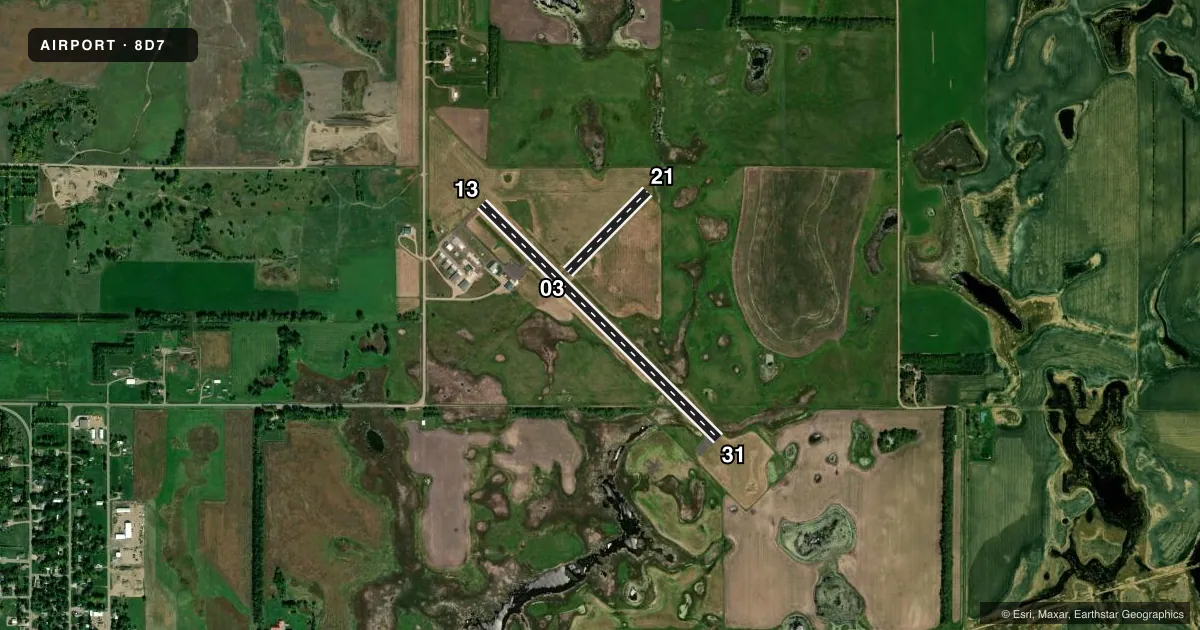
Airport sketch
Runways drawn to scale from FAA survey coordinates, rendered over satellite imagery. Not for navigation.
Approaches & charts
Services on the field
Fuel grades, oxygen, maintenance, ramp storage and lighting — as declared to the FAA by the airport operator.
Fuel & services
- Fuel
- 100LLA
- Oxygen (bottled)
- Not available
- Oxygen (bulk)
- Not available
- Airframe repair
- Major
- Power plant repair
- Major
- Other services
- AGRI,RNTL
Ramp & ground
- Transient storage
- Tie-down
- Hangar
- Landing fee
- No fee published
- Customs
- Not available
- Lighting schedule
- SEE RMK
- Beacon schedule
- SS-SR
- Beacon
- White / Green (civil land)(WG)
- Wind indicator
- Lighted
- Segmented circle
- No
Fuel & FBOs
Cheapest 100LL and Jet A on the field and nearby. Always confirm with the FBO before taxi.
Airport notes
Surface conditions, obstructions, local procedures, lighting outages and other notes published with each FAA cycle.
General notes
- RY 21 HAS 3 FT FENCE 215 FT FM THLD.
- WILDLIFE AROUND AND INVOF ARPT.
- CAUTION: UNLIT TOWER 300 FEET HIGH, 10 NM W OF AIRPORT.
- FOR CD CTC MINNEAPOLIS ARTCC AT 651-463-5588.
Lighting notes
- ACTVT PAPI RWY 13 & 31; MIRL RWY 13/31 - CTAF.
Fuel notes
- 100LLFUEL AVBL 24 HRS WITH CREDIT CARD.
Approach & departure obstructions
- 03RWY 03/21 MKD WITH WHITE MKR CONES.
Other notes
- UNICOM UNMON.
VFR map & nearby airports
VFR sectional. Tap any ICAO chip to open that airport.
Key facts · 8D7
Answer card- ICAO
- 8D7
- Name
- CLARK COUNTY
- Location
- CLARK, SOUTH DAKOTA
- Elevation
- 1,793.2 ft MSL
- Traffic pattern altitude
- 2,793.2 ft MSL (1,000 AGL)
- Control tower
- Non-towered (use CTAF)
- Total runways
- 2
- Longest runway
- 13/31 · 3,697 ft
- Published ILS approaches
- 0
- Published frequencies
- 2
- Magnetic variation
- 4°
- Current flight rules
- VFR
- Current wind
- 000° at 4 kt
- Favored runway now
- RWY 31
Clark County Airport sits in Clark, South Dakota. Field elevation is 1,793.2 ft MSL. The airport has two runways. The longest is runway 13/31 at 3,697 ft asphalt. Runway 03/21 is 1,258 ft turf. There is no control tower. CTAF and UNICOM are both 122.8. UNICOM is unmonitored.
No ILS approaches are published here. Pattern altitude is not published. For a light piston, plan on the standard 1,000 ft AGL unless the current Chart Supplement says otherwise. Runway 13 and runway 31 have PAPI. Medium intensity runway lights on 13 and 31 are controlled by CTAF. Runway 03/21 is marked with yellow and black split barrels. Runway 21 has a 3-foot fence 215 feet from the threshold. Wildlife is present around the airport, so keep a sharp scan on taxi, takeoff and landing.
Fuel is available 24 hours with credit card. No on-field FBOs are listed. For clearance delivery, contact Minneapolis ARTCC at 651-463-5588. There is also an unlit 300-foot tower about 10 NM west of the airport, so keep that in mind on arrival and departure.